Dormettingen
Located in Zollernalbkreis, Tübingen Region Coordinates: 48°14′13″ N 8°46′24″ E
- Population
- 1,076
- 1.1K
- Elevation
- 651 m
- above sea level
- Local time
- UTC+01:00
- Europe/Berlin · UTC+01:00
- Places inside
- 2
- listed under Dormettingen
- Airports
- STR Stuttgart Airport60 km
- FKB Karlsruhe Baden-Baden Airport79 km
About Dormettingen
Dormettingen is a village. Location: Zollernalbkreis, Tübingen Region. Population: 1,076. Elevation: 651 m. The best months to visit are June–August. The nearest airport is Stuttgart Airport (60 km). Nearby sights include Dotternhausen Pfarrhaus St. Martin and Palmbühl.
Photos of Dormettingen
-
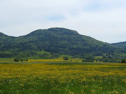
Schafberg V i c R a · CC BY-SA 3.0

Climate of Dormettingen
Best months for sightseeingBest months for sightseeing: June–August.
This month · November
A cold month
Day 6° · Night -1° · Rain 74 mm
- Hottest month
- July (day 22°)
- Coldest month
- January (night -4°)
- Wettest month
- June (99 mm)
- Driest month
- March (59 mm)
Bars: average monthly low and high temperature. Below: precipitation. Monthly averages for 1970–2000 at about 18 km resolution, adjusted for elevation. Highlighted months are mild and relatively dry. Source: WorldClim 2.1 (CC BY 4.0).
Show values as a table
| Month | Jan | Feb | Mar | Apr | May | Jun | Jul | Aug | Sep | Oct | Nov | Dec |
|---|---|---|---|---|---|---|---|---|---|---|---|---|
| Average high (°C) | 2° | 3° | 8° | 11° | 17° | 19° | 22° | 22° | 18° | 12° | 6° | 3° |
| Average low (°C) | -4° | -4° | -1° | 1° | 6° | 9° | 11° | 11° | 7° | 3° | -1° | -3° |
| Precipitation (mm) | 65 | 66 | 59 | 67 | 88 | 99 | 87 | 77 | 60 | 69 | 74 | 78 |
How to get to Dormettingen
The nearest airport is Stuttgart Airport (STR), 60 km to the northeast as the crow flies. The nearest large city is Reutlingen, 43 km to the northeast.
Airports
- Stuttgart Airport (STR) Stuttgart 60 kmnortheast
- Karlsruhe Baden-Baden Airport (FKB) Rheinmünster 79 kmnorthwest
- Bodensee Airport Friedrichshafen (FDH) Friedrichshafen 84 kmsoutheast
Nearby large cities
- Reutlingen Population: 112.6K 43 kmnortheast
- Stuttgart Population: 612.7K 68 kmnortheast
- Pforzheim Population: 119.3K 72 kmnorth
- Freiburg im Breisgau Population: 237.5K 74 kmwest
- Winterthur Population: 111.8K 81 kmsouth
Straight-line distances; road distances are longer. Airport data: OurAirports.
Day trips from Dormettingen
Within 100 km: 833 historic and cultural sites, 3,149 natural sites, 890 lakes, rivers and coasts.
0–25 km360 places
- Zundelberg Mountain 20 kmS
- Zitterboch Mountain 19 kmSE
- Winkel Mountain 10 kmE
- Wenzelstein Mountain 6 kmSE
25–60 km1,729 places
- Randen Mountain 54 kmS
- Hoher Randen (Südliche Höhe) Mountain 53 kmS
- Lange Rande Mountain 58 kmS
- Seebuck Mountain 58 kmS
60–100 km2,783 places
- Mainau Island 67 kmSE
- Fahr Abbey Attraction 96 kmS
- Dominikanerinsel Konstanz Island 70 kmSE
- Strandbad Steckborn Beach 66 kmS
Straight-line distances.
Places in Dormettingen
2 placesBar: population relative to the most populous place in this list.
Heritage & sights1
- Dormettingen Concentration Camp · Historic site
Nearby attractions & nature
Everything nearby-
Dotternhausen Pfarrhaus St. Martin Attraction, Dotternhausen1.7 km SE
-
Palmbühl Mountain, Schömberg2.6 km S
-
Dautmergen Concentration Camp Historic site, Dautmergen2.4 km W
-
Aspen Mountain, Schömberg3.1 km SW
-
Erzingen Concentration Camp Historic site, Balingen3.5 km NE
-
Hörnle Mountain, Rosenfeld3.4 km W
Sources & licences
Data last updated: