Kleinbirkach
Located in Ebrach, Markt, Landkreis Bamberg Coordinates: 49°47′29″ N 10°28′54″ E
- Elevation
- 353 m
- above sea level
- Local time
- UTC+01:00
- Europe/Berlin · UTC+01:00
- Airports
- NUE Nuremberg Airport54 km
- ERF Erfurt-Weimar Airport136 km
About Kleinbirkach
Kleinbirkach is a village. Location: Ebrach, Markt, Landkreis Bamberg. Elevation: 353 m. The best months to visit are June–August. The nearest airport is Nuremberg Airport (54 km). Nearby sights include Steigerwald and Alter Dreifrankenstein.
Photos of Kleinbirkach
-
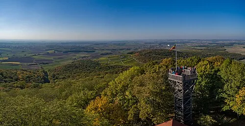
Steigerwald BeneFoto · CC BY-SA 4.0

Climate of Kleinbirkach
Best months for sightseeingBest months for sightseeing: June–August.
This month · November
A cold month
Day 6° · Night 1° · Rain 57 mm
- Hottest month
- July (day 23°)
- Coldest month
- January (night -3°)
- Wettest month
- June (80 mm)
- Driest month
- February (48 mm)
Bars: average monthly low and high temperature. Below: precipitation. Monthly averages for 1970–2000 at about 18 km resolution, adjusted for elevation. Highlighted months are mild and relatively dry. Source: WorldClim 2.1 (CC BY 4.0).
Show values as a table
| Month | Jan | Feb | Mar | Apr | May | Jun | Jul | Aug | Sep | Oct | Nov | Dec |
|---|---|---|---|---|---|---|---|---|---|---|---|---|
| Average high (°C) | 2° | 4° | 8° | 13° | 19° | 21° | 23° | 23° | 19° | 13° | 6° | 4° |
| Average low (°C) | -3° | -3° | 0° | 3° | 7° | 10° | 12° | 12° | 8° | 4° | 1° | -2° |
| Precipitation (mm) | 54 | 48 | 53 | 51 | 64 | 80 | 76 | 58 | 55 | 60 | 57 | 65 |
How to get to Kleinbirkach
The nearest airport is Nuremberg Airport (NUE), 54 km to the southeast as the crow flies. The nearest large city is Würzburg, 38 km to the west.
Airports
- Nuremberg Airport (NUE) Nuremberg 54 kmsoutheast
- Erfurt-Weimar Airport (ERF) Erfurt 136 kmnorth
- Frankfurt Main Airport (FRA) Frankfurt am Main 141 kmwest
Nearby large cities
- Würzburg Population: 133.7K 38 kmwest
- Erlangen Population: 102.7K 44 kmsoutheast
- Fürth Population: 132K 51 kmsoutheast
- Nuremberg Population: 515.5K 57 kmsoutheast
- Heilbronn Population: 120.7K 117 kmsouthwest
Straight-line distances; road distances are longer. Airport data: OurAirports.
Day trips from Kleinbirkach
Within 100 km: 1,307 historic and cultural sites, 4,097 natural sites, 802 lakes, rivers and coasts.
0–25 km663 places
- Badsee Lake 15 kmN
- Wolfsee Lake 18 kmS
- Tränksee Lake 10 kmSW
- Sperbersee Lake 18 kmSW
25–60 km2,074 places
- Uzbach River 36 kmSW
- Welles Weiher Lake 39 kmSE
- Unterer Herrnsee Lake 32 kmE
- Stephansweiher Lake 43 kmSE
60–100 km3,469 places
- Waldstadion Weismain Landmark 64 kmNE
- Hessental Concentration Camp Historic site 92 kmSW
- Spitzelberg Mountain 75 kmE
- Stollenberg Mountain 73 kmE
Straight-line distances.
Nearby attractions & nature
Everything nearby-
Steigerwald Mountain, Bavaria2.8 km S
-
Alter Dreifrankenstein Landmark, Geiselwind, Markt1.1 km W
-
Traubenberg Mountain, Geiselwind, Markt3 km S
-
Schafknock Natural site, Bavaria2.8 km N
-
Wildenberg Natural site, Bavaria3 km N
-
Schießhügel Mountain, Geiselwind, Markt4 km W
Sources & licences
Data last updated: