Annahütte
Located in Schipkau, Landkreis Oberspreewald-Lausitz Coordinates: 51°33′42″ N 13°53′36″ E

- Elevation
- 129 m
- above sea level
- Local time
- UTC+01:00
- Europe/Berlin · UTC+01:00
- Airports
- DRS Dresden Airport48 km
- BER Berlin Brandenburg Airport93 km
About Annahütte
Annahütte is a village. Location: Schipkau, Landkreis Oberspreewald-Lausitz. Elevation: 129 m. The best months to visit are May–September. The nearest airport is Dresden Airport (48 km). Nearby sights include Sallgaster Wald and Annahütte, Henriettenkirche.
At a glance
- Area
- 6.5 km²
Source: Wikidata
Photos of Annahütte
-

Global Fish · CC BY-SA 4.0 -

Z thomas · CC BY 3.0 -

Z thomas · CC BY 3.0 -

Hans G. Oberlack · CC BY 4.0


Climate of Annahütte
Best months for sightseeingBest months for sightseeing: May–September.
This month · November
A cold month
Day 7° · Night 2° · Rain 51 mm
- Hottest month
- July (day 24°)
- Coldest month
- January (night -3°)
- Wettest month
- July (83 mm)
- Driest month
- April (33 mm)
Bars: average monthly low and high temperature. Below: precipitation. Monthly averages for 1970–2000 at about 18 km resolution, adjusted for elevation. Highlighted months are mild and relatively dry. Source: WorldClim 2.1 (CC BY 4.0).
Show values as a table
| Month | Jan | Feb | Mar | Apr | May | Jun | Jul | Aug | Sep | Oct | Nov | Dec |
|---|---|---|---|---|---|---|---|---|---|---|---|---|
| Average high (°C) | 3° | 4° | 8° | 13° | 19° | 22° | 24° | 23° | 19° | 14° | 7° | 4° |
| Average low (°C) | -3° | -2° | 1° | 3° | 8° | 11° | 13° | 12° | 9° | 5° | 2° | -1° |
| Precipitation (mm) | 44 | 39 | 48 | 33 | 54 | 56 | 83 | 70 | 54 | 41 | 51 | 46 |
Other places to visit in this season: May June July August September
How to get to Annahütte
The nearest airport is Dresden Airport (DRS), 48 km to the south as the crow flies. The nearest large city is Dresden, 58 km to the south.
Airports
- Dresden Airport (DRS) Dresden 48 kmsouth
- Berlin Brandenburg Airport (BER) Berlin 93 kmnorth
- Leipzig/Halle Airport (LEJ) Schkeuditz 116 kmwest
Nearby large cities
- Dresden Population: 564.9K 58 kmsouth
- Chemnitz Population: 247.2K 105 kmsouthwest
- Leipzig Population: 505K 109 kmwest
- Potsdam Population: 184.8K 109 kmnorthwest
- Berlin Population: 3.4M 112 kmnorth
Straight-line distances; road distances are longer. Airport data: OurAirports.
Day trips from Annahütte
Within 100 km: 282 historic and cultural sites, 1,743 natural sites, 737 lakes, rivers and coasts.
0–25 km131 places
- Wiesenteich Lake 21 kmE
- Wergteich Lake 21 kmNE
- Seeser Teich Lake 25 kmN
- Schneidemühlenteich Lake 14 kmW
25–60 km804 places
- Buschteich Lake 42 kmE
- Obersee Lake 41 kmE
- Meierei-See Lake 50 kmN
- Winkelteich Lake 44 kmSE
60–100 km1,827 places
- Erzgebirge Mountain 74 kmS
- Pirna-Sonnenstein Mountain 68 kmS
- Vosí vrch Mountain 83 kmSE
- Lutzke River 69 kmNE
Straight-line distances.
Nearby attractions & nature
Everything nearby-
Sallgaster Wald Natural site, Brandenburg3.6 km W
-
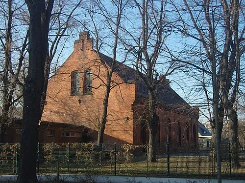
Annahütte, Henriettenkirche Attraction, Schipkau4.3 km S
-
Friedrichsthal Natural site, Brandenburg6.5 km SW
-
 Early Camp Senftenberg Historic site, Senftenberg8.6 km SE
-
Großer Wolfsberg Mountain, Finsterwalde8.8 km W
-
Kleiner Wolfsberg Mountain, Lichterfeld-Schacksdorf7.7 km W
Other cities and towns in Schipkau
-
 Hörlitz Village, Schipkau5.4 km SE
-
Treuhand-Siedlung Village, Schipkau3.2 km S
-
Gewoba-Siedlung Village, Schipkau3.2 km S
-
Hörlitzer Flur Village, Schipkau4.2 km SE
-
Paradies Village, Schipkau5 km SE
-
Vogelberg Village, Schipkau5.1 km S
Sources & licences
Data last updated: · 2 independent sources