Nuthe-Urstromtal
Located in Landkreis Teltow-Fläming, Brandenburg Coordinates: 52°06′01″ N 13°12′15″ E
- Population
- 6,325
- 6.3K
- Elevation
- 48 m
- above sea level
- Local time
- UTC+01:00
- Europe/Berlin · UTC+01:00
- Places inside
- 35
- listed under Nuthe-Urstromtal
- Airports
- BER Berlin Brandenburg Airport36 km
- LEJ Leipzig/Halle Airport101 km
About Nuthe-Urstromtal
Nuthe-Urstromtal is a village. Location: Landkreis Teltow-Fläming, Brandenburg. Population: 6,325. Elevation: 48 m.
Nuthe-Urstromtal is a municipality in the Teltow-Fläming district of Brandenburg, Germany. By area, it is the largest rural municipality ("Gemeinde") in Germany.
Source: Wikipedia · CC BY-SA 4.0
Photos of Nuthe-Urstromtal
-
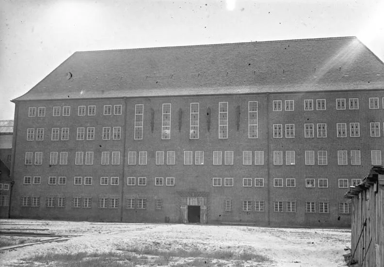
Early Camp Brandenburg Georg Pahl · CC BY-SA 3.0 de

Population of Nuthe-Urstromtal over time
| 1990 | 7,047 | |
|---|---|---|
| 2000 | 7,371 | |
| 2010 | 6,790 | |
| 2020 | 6,565 | |
| 2025 | 6,249 |
Censuses and official estimates; source: Wikidata.
Climate of Nuthe-Urstromtal
Best months for sightseeingBest months for sightseeing: May–August.
This month · November
A cold month
Day 7° · Night 2° · Rain 43 mm
- Hottest month
- July (day 25°)
- Coldest month
- January (night -3°)
- Wettest month
- July (65 mm)
- Driest month
- April (33 mm)
Bars: average monthly low and high temperature. Below: precipitation. Monthly averages for 1970–2000 at about 18 km resolution, adjusted for elevation. Highlighted months are mild and relatively dry. Source: WorldClim 2.1 (CC BY 4.0).
Show values as a table
| Month | Jan | Feb | Mar | Apr | May | Jun | Jul | Aug | Sep | Oct | Nov | Dec |
|---|---|---|---|---|---|---|---|---|---|---|---|---|
| Average high (°C) | 3° | 5° | 9° | 14° | 20° | 23° | 25° | 24° | 19° | 14° | 7° | 4° |
| Average low (°C) | -3° | -2° | 0° | 3° | 8° | 11° | 13° | 12° | 9° | 5° | 2° | -1° |
| Precipitation (mm) | 39 | 34 | 37 | 33 | 53 | 55 | 65 | 59 | 48 | 35 | 43 | 45 |
How to get to Nuthe-Urstromtal
The nearest airport is Berlin Brandenburg Airport (BER), 36 km to the northeast as the crow flies. The nearest large city is Potsdam, 35 km to the north.
Airports
- Berlin Brandenburg Airport (BER) Berlin 36 kmnortheast
- Leipzig/Halle Airport (LEJ) Schkeuditz 101 kmsouthwest
- Dresden Airport (DRS) Dresden 114 kmsouth
Nearby large cities
- Potsdam Population: 184.8K 35 kmnorth
- Berlin Population: 3.4M 49 kmnorth
- Leipzig Population: 505K 102 kmsouthwest
- Magdeburg Population: 244.3K 108 kmwest
- Halle Population: 237.9K 109 kmsouthwest
Straight-line distances; road distances are longer. Airport data: OurAirports.
Day trips from Nuthe-Urstromtal
Within 100 km: 518 historic and cultural sites, 1,756 natural sites, 1,180 lakes, rivers and coasts.
0–25 km162 places
- Wolziger See Lake 20 kmE
- Vordersee Lake 13 kmNW
- Teufels-See Lake 25 kmNW
- Siethener See Lake 21 kmN
25–60 km1,173 places
- Schlachtensee Lake 38 kmN
- Valentinswerder Island 52 kmN
- Scharfenberg Island 52 kmN
- Dahme River River 46 kmNE
60–100 km2,119 places
- Lutzke River 99 kmE
- Werder Island 99 kmN
- Insel im Bützsee Island 84 kmN
- Wulfswerder Island 100 kmNW
Straight-line distances.
Places in Nuthe-Urstromtal
35 placesCities & villages23
- Ahrensdorf · Village
- Berkenbrück · Village
- Dobbrikow · Village
- Dümde · Village
- Felgentreu · Village
- Frankenförde · Village
- Gottow · Village
- Gottsdorf · Village
- Hennickendorf · Village
- Holbeck · Village
- Jänickendorf · Village
- Kemnitz · Village
- Liebätz · Village
- Lynow · Village
- Märtensmühle · Village
- Nettgendorf · Village
- Ruhlsdorf · Village
- Scharfenbrück · Village
- Schönefeld · Village
- Schöneweide · Village
- Stülpe · Village
- Woltersdorf · Village
- Zülichendorf · Village
Mountains & nature11
- Burgberg · Mountain
- Dämmchenberg · Mountain
- Eichberg · Mountain
- Fuchsberg · Mountain
- Golmberg · Mountain
- Hohendorf · Mountain
- Krugberg · Mountain
- Pekenberg · Mountain
- Schulische Berg · Mountain
- Schützenberg · Mountain
- Spitzberg · Mountain
Heritage & sights1
- Early Camp Brandenburg · Historic site
Nearby attractions & nature
Everything nearby-
Eiserbach River, Brandenburg0.8 km SE
-
Steinerfließ River, Brandenburg1.4 km N
-
Königsgraben River, Brandenburg1.4 km NW
-
Forst Woltersdorf Natural site, Brandenburg3.7 km SE
-
Mürtelberg Mountain, Luckenwalde5.1 km W
-
Staatsforst Kummersdorf Natural site, Brandenburg5.6 km NE
Other cities and towns in Landkreis Teltow-Fläming
-
 Neuhof Village, Jüterbog8 km SW
-
 Wiesenhagen Village, Trebbin8.6 km N
-
Weinberge Village, Luckenwalde4.2 km SW
-
Neu Frankenfelde Village, Luckenwalde4.4 km W
Sources & licences
Data last updated: · 2 independent sources