Mattendorf
Located in Wiesengrund, Wokrejs Sprjewja-Nysa Coordinates: 51°40′02″ N 14°33′06″ E
- Elevation
- 96 m
- above sea level
- Local time
- UTC+01:00
- Europe/Berlin · UTC+01:00
- Airports
- DRS Dresden Airport81 km
- IEG Zielona Góra-Babimost Airport101 km
About Mattendorf
Mattendorf is a village. Location: Wiesengrund, Wokrejs Sprjewja-Nysa. Elevation: 96 m. The best months to visit are May–September. The nearest airport is Dresden Airport (81 km). Nearby sights include Wolschinagraben and Narinaberg.
Photos of Mattendorf
-
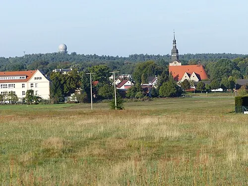
Hoher Berg Lhbhl · CC BY-SA 4.0

Climate of Mattendorf
Best months for sightseeingBest months for sightseeing: May–September.
This month · November
A cold month
Day 7° · Night 1° · Rain 47 mm
- Hottest month
- July (day 24°)
- Coldest month
- January (night -3°)
- Wettest month
- July (89 mm)
- Driest month
- April (34 mm)
Bars: average monthly low and high temperature. Below: precipitation. Monthly averages for 1970–2000 at about 18 km resolution, adjusted for elevation. Highlighted months are mild and relatively dry. Source: WorldClim 2.1 (CC BY 4.0).
Show values as a table
| Month | Jan | Feb | Mar | Apr | May | Jun | Jul | Aug | Sep | Oct | Nov | Dec |
|---|---|---|---|---|---|---|---|---|---|---|---|---|
| Average high (°C) | 2° | 4° | 8° | 13° | 19° | 22° | 24° | 24° | 19° | 14° | 7° | 4° |
| Average low (°C) | -3° | -2° | 1° | 3° | 8° | 11° | 13° | 13° | 9° | 5° | 1° | -1° |
| Precipitation (mm) | 43 | 38 | 42 | 34 | 59 | 54 | 89 | 69 | 51 | 39 | 47 | 46 |
Other places to visit in this season: May June July August September
How to get to Mattendorf
The nearest airport is Dresden Airport (DRS), 81 km to the southwest as the crow flies. The nearest large city is Dresden, 89 km to the southwest.
Airports
- Dresden Airport (DRS) Dresden 81 kmsouthwest
- Zielona Góra-Babimost Airport (IEG) Nowe Kramsko 101 kmnortheast
- Berlin Brandenburg Airport (BER) Berlin 106 kmnorthwest
Nearby large cities
- Dresden Population: 564.9K 89 kmsouthwest
- Berlin Population: 3.4M 123 kmnorthwest
- Potsdam Population: 184.8K 130 kmnorthwest
- Chemnitz Population: 247.2K 146 kmsouthwest
- Leipzig Population: 505K 156 kmwest
Straight-line distances; road distances are longer. Airport data: OurAirports.
Day trips from Mattendorf
Within 100 km: 205 historic and cultural sites, 1,167 natural sites, 602 lakes, rivers and coasts.
0–25 km101 places
- Unterteich Lake 17 kmN
- Teufelsteich Lake 23 kmNW
- Speicherbecken Spremberg Lake 12 kmW
- Schloß-Teich Lake 5 kmNW
25–60 km472 places
- Lutzke River 36 kmN
- Buschteich Lake 29 kmS
- Obersee Lake 27 kmS
- Zeuster See Lake 55 kmN
60–100 km1,401 places
- Pirna-Sonnenstein Mountain 90 kmSW
- Vosí vrch Mountain 87 kmS
- Kalisch See Lake 92 kmN
- Meierei-See Lake 63 kmNW
Straight-line distances.
Nearby attractions & nature
Everything nearby-
Wolschinagraben River, Brandenburg3 km W
-
Narinaberg Mountain, Brandenburg4.4 km SE
-
Hoher Berg Mountain, Döbern6.3 km S
-
Marienberg Mountain, Neiße-Malxetal5.7 km S
-
Weinberg Mountain, Felixsee5.8 km S
-
Hornower Wald Natural site, Brandenburg5.4 km SW
Other cities and towns in Wiesengrund


Sources & licences
Data last updated: · 2 independent sources