- Population
- 45,555
- 45.6K
- Elevation
- 66 m
- above sea level
- Local time
- UTC+01:00
- Europe/Berlin · UTC+01:00
- Places inside
- 15
- listed under Brühl
- Airports
- CGN Cologne Bonn Airport17 km
- DUS Düsseldorf Airport52 km
About Brühl
Brühl is a village. Location: Rhein-Erft-Kreis, Cologne District. Population: 45,555. Elevation: 66 m.
Brühl (pronounced [bʁyːl] ) is a town in the Rhineland, Germany. It is located in the district of Rhine-Erft, 20 km south of the Cologne city center and at the edge of the Rhineland Nature Park, a famous nature reserve. With the palaces of Augustusburg and Falkenlust, both UNESCO World Heritage Sites, the moated castle of Schallenburg, the lake district within the Kottenforest, and the Phantasialand amusement park, it ranks among the most important tourist destinations in the Rhineland.
Source: Wikipedia · CC BY-SA 4.0
Photos of Brühl
-
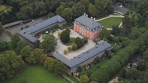
Burg Wolkenkratzer · CC BY-SA 3.0 -
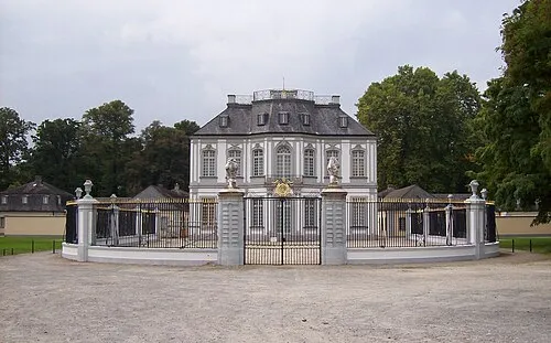
Jagdschloß Falkenlust Stefan Didam - Schmallenberg · CC BY-SA 3.0


Population of Brühl over time
| 1975 | 44,305 | |
|---|---|---|
| 2015 | 44,768 | |
| 2017 | 44,144 | |
| 2019 | 44,397 | |
| 2021 | 43,998 | |
| 2022 | 44,804 | |
| 2023 | 45,515 | |
| 2024 | 45,555 | |
| 2025 | 45,653 |
Censuses and official estimates; source: Wikidata.
Climate of Brühl
Best months for sightseeingBest months for sightseeing: May–September.
This month · November
A cold month
Day 9° · Night 3° · Rain 55 mm
- Hottest month
- August (day 24°)
- Coldest month
- February (night 0°)
- Wettest month
- July (73 mm)
- Driest month
- February (42 mm)
Bars: average monthly low and high temperature. Below: precipitation. Monthly averages for 1970–2000 at about 18 km resolution, adjusted for elevation. Highlighted months are mild and relatively dry. Source: WorldClim 2.1 (CC BY 4.0).
Show values as a table
| Month | Jan | Feb | Mar | Apr | May | Jun | Jul | Aug | Sep | Oct | Nov | Dec |
|---|---|---|---|---|---|---|---|---|---|---|---|---|
| Average high (°C) | 5° | 7° | 10° | 14° | 19° | 21° | 24° | 24° | 20° | 15° | 9° | 7° |
| Average low (°C) | 0° | 0° | 3° | 5° | 9° | 12° | 14° | 13° | 10° | 7° | 3° | 2° |
| Precipitation (mm) | 47 | 42 | 52 | 50 | 64 | 71 | 73 | 63 | 57 | 50 | 55 | 54 |
Other places to visit in this season: May June July August September
How to get to Brühl
The nearest airport is Cologne Bonn Airport (CGN), 17 km to the east as the crow flies. The nearest large city is Cologne, 12 km to the north.
Airports
- Cologne Bonn Airport (CGN) Köln (Cologne) 17 kmeast
- Düsseldorf Airport (DUS) Düsseldorf 52 kmnorth
- Maastricht Aachen Airport (MST) Maastricht 81 kmwest
Nearby large cities
- Cologne Population: 1M 12 kmnorth
- Bonn Population: 330.6K 17 kmsoutheast
- Leverkusen Population: 162.7K 23 kmnorth
- Bergisch Gladbach Population: 106.2K 23 kmnortheast
- Solingen Population: 164.4K 40 kmnorth
Straight-line distances; road distances are longer. Airport data: OurAirports.
Day trips from Brühl
Within 100 km: 573 historic and cultural sites, 2,897 natural sites, 880 lakes, rivers and coasts.
0–25 km203 places
- Kemper Werth Island 15 kmSE
- Liblarer See Lake 5 kmW
- Rotter See Lake 15 kmE
- Decksteiner Weiher Lake 8 kmN
25–60 km1,324 places
- Hohe Mark Mountain 60 kmSW
- Rocherather Wald Natural site 59 kmSW
- Raerener Wald Natural site 58 kmW
- Murringer Wald Natural site 58 kmSW
60–100 km2,823 places
- Île du Moulin Island 97 kmW
- Île Monsin Island 92 kmW
- Île de Franche Garenne Island 88 kmW
- Lac de la Gileppe Lake 70 kmSW
Straight-line distances.
Places in Brühl
15 placesBar: population relative to the most populous place in this list.
Cities & villages11
Heritage & sights3
- Jagdschloß Falkenlust · Historic site
- Max-Ernst-Museum · Museum
- Schloß Augustusburg · Historic site
Nearby attractions & nature
Everything nearby-
Anlage 4101, Mast 93 Landmark, Hürth3.8 km NW
-
Burg Historic site, Bornheim7 km S
-
Auf der Sandkaul Natural site, North Rhine-Westphalia5.3 km S
-
Liblarer See Lake, North Rhine-Westphalia5.5 km W
-
Duffesbach River, North Rhine-Westphalia6.4 km N
-
FlowFact Tower Landmark, Cologne8.1 km NE
Sources & licences
Data last updated: · 2 independent sources