Eifelkreis Bitburg-Prüm
Located in Rhineland-Palatinate, Germany Coordinates: 50°04′33″ N 6°22′48″ E
- Population
- 99,788
- 99.8K
- Elevation
- 340 m
- above sea level
- Local time
- UTC+01:00
- Europe/Berlin · UTC+01:00
- Places inside
- 234
- listed under Eifelkreis Bitburg-Prüm
- Airports
- LUX Luxembourg-Findel International Airport51 km
- HHN Frankfurt-Hahn Airport65 km
About Eifelkreis Bitburg-Prüm
Eifelkreis Bitburg-Prüm is a municipality. Location: Rhineland-Palatinate, Germany. Population: 99,788. Elevation: 340 m. The best months to visit are June–August. The nearest airport is Luxembourg-Findel International Airport (51 km). Nearby sights include Dierbach and Bohnenbach.
Photos of Eifelkreis Bitburg-Prüm
-
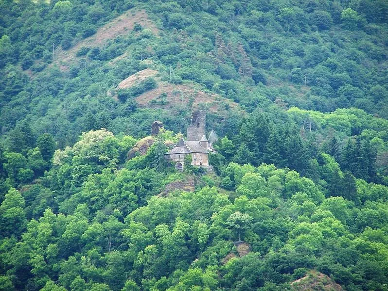
Schloß Falkenstein Brbbl · CC BY-SA 3.0

Climate of Eifelkreis Bitburg-Prüm
Best months for sightseeingBest months for sightseeing: June–August.
This month · November
A cold month
Day 7° · Night 2° · Rain 89 mm
- Hottest month
- August (day 22°)
- Coldest month
- February (night -1°)
- Wettest month
- December (97 mm)
- Driest month
- April (63 mm)
Bars: average monthly low and high temperature. Below: precipitation. Monthly averages for 1970–2000 at about 18 km resolution, adjusted for elevation. Highlighted months are mild and relatively dry. Source: WorldClim 2.1 (CC BY 4.0).
Show values as a table
| Month | Jan | Feb | Mar | Apr | May | Jun | Jul | Aug | Sep | Oct | Nov | Dec |
|---|---|---|---|---|---|---|---|---|---|---|---|---|
| Average high (°C) | 4° | 5° | 9° | 12° | 17° | 20° | 22° | 22° | 18° | 13° | 7° | 4° |
| Average low (°C) | -1° | -1° | 1° | 3° | 8° | 10° | 12° | 12° | 9° | 6° | 2° | 0° |
| Precipitation (mm) | 88 | 69 | 80 | 63 | 73 | 77 | 78 | 64 | 79 | 81 | 89 | 97 |
How to get to Eifelkreis Bitburg-Prüm
The nearest airport is Luxembourg-Findel International Airport (LUX), 51 km to the south as the crow flies. The nearest large city is Trier, 40 km to the southeast.
Airports
- Luxembourg-Findel International Airport (LUX) Luxembourg 51 kmsouth
- Frankfurt-Hahn Airport (HHN) Frankfurt am Main (Lautzenhausen) 65 kmeast
- Liège Airport (LGG) Grâce-Hollogne 91 kmnorthwest
Nearby large cities
- Trier Population: 100.1K 40 kmsoutheast
- Aachen Population: 265.2K 81 kmnorth
- Liège Population: 195.3K 85 kmnorthwest
- Bonn Population: 330.6K 89 kmnortheast
- Koblenz Population: 107.3K 91 kmeast
Straight-line distances; road distances are longer. Airport data: OurAirports.
Day trips from Eifelkreis Bitburg-Prüm
Within 100 km: 419 historic and cultural sites, 2,857 natural sites, 783 lakes, rivers and coasts.
0–25 km344 places
- Steinkopf Mountain 20 kmNW
- Reinersberg Mountain 24 kmNW
- Preis Berg Mountain 21 kmNW
- Schwirzbierg Mountain 23 kmW
25–60 km1,142 places
- Lac de Nisramont Lake 52 kmW
- Lac de Robertville Lake 45 kmNW
- Mont de la Tour de Coo Mountain 51 kmNW
- Steiner Berg Mountain 31 kmNW
60–100 km2,573 places
- Île du Moulin Island 78 kmNW
- Île Monsin Island 84 kmNW
- Île de Franche Garenne Island 85 kmNW
- Lac de la Gileppe Lake 63 kmNW
Straight-line distances.
Eifelkreis Bitburg-Prüm and similar cities
Side by side with cities of similar size in the same country: population, elevation and climate.
| Measure | Eifelkreis Bitburg-Prüm | Trier | Erlangen | Schwerin |
|---|---|---|---|---|
| Population | 99.8K | 100.1K | 102.7K | 96.6K |
| Elevation | 340 m | 141 m | 290 m | 48 m |
| Summer day (hottest month) | 22° | 24° | 24° | 23° |
| Winter night (coldest month) | -1° | 0° | -3° | -2° |
| Annual rainfall | 938 mm | 817 mm | 745 mm | 628 mm |
| Best months | Jun–Aug | Jun–Sep | May–Sep | Jun–Aug |
| Distance | — | 40 km | 337 km | 526 km |
Climate values are 1970–2000 monthly averages; straight-line distance.
Places in Eifelkreis Bitburg-Prüm
234 places
Bitburg
Population: 15.6K
Prüm
Population: 5.3K
Speicher
Population: 3.7K

Irrel
Population: 1.7K

Bollendorf
Population: 1.6K
Arzfeld
Population: 1.5K
- 7 Schönecken 1.4K
- 8 Orenhofen 1.4K
- 9 Bleialf 1.4K
- 10 Neuerburg 1.3K
- 11 Rittersdorf 1.3K
- 12 Badem 1.3K
- 13 Dudeldorf 1.2K
- 14 Herforst 1.2K
- 15 Körperich 1.1K
- 16 Echternacherbrück 1.1K
- 17 Mettendorf 1.1K
- 18 Wolsfeld 1.1K
- 19 Bettingen 1.1K
- 20 Waxweiler 1.1K
- 21 Weinsheim 1K
- 22 Ferschweiler 1K
- 23 Pronsfeld 987
- 24 Kyllburg 939
- 25 Spangdahlem 913
- 26 Daleiden 906
- 27 Neidenbach 846
- 28 Winterspelt 842
- 29 Wißmannsdorf 796
- 30 Preist 734
- 31 Wallersheim 718
- 32 Burbach 708
- 33 Rommersheim 671
- 34 Habscheid 656
- 35 Fließem 648
- 36 Holsthum 625
- 37 Lünebach 615
- 38 Auw bei Prüm 601
- 39 Olzheim 581
- 40 Nattenheim 576
- 41 Büdesheim 571
- 42 Oberkail 570
- 43 Oberweis 562
- 44 Bickendorf 559
- 45 Biersdorf am See 553
- 46 Messerich 546
- 47 Malberg 545
- 48 Prümzurlay 539
- 49 Metterich 534
- 50 Gondenbrett 479
- 51 Alsdorf 477
- 52 Schwirzheim 458
- 53 Gilzem 443
- 54 Utscheid 442
- 55 Roth bei Prüm 440
- 56 Ehlenz 438
- 57 Röhl 435
- 58 Geichlingen 434
- 59 Nusbaum 433
- 60 Baustert 425
Bar: population relative to the most populous place in this list.
Nearby attractions & nature
Everything nearby-
Dierbach River, Rhineland-Palatinate0.6 km E
-
Bohnenbach River, Rhineland-Palatinate0.9 km NW
-
Weiherbach River, Rhineland-Palatinate2.2 km NW
-
Geweber Wald Natural site, Rhineland-Palatinate2.9 km E
-
Wald Scheid Natural site, Rhineland-Palatinate5.4 km SE
-
Kleiner Ehlenzbach River, Rhineland-Palatinate5 km E
-
Hardt Wald Natural site, Rhineland-Palatinate5.8 km E
-
Die Hecke Natural site, Rhineland-Palatinate6.1 km NE
Sources & licences
Data last updated: