- Population
- 1,546
- 1.5K
- Elevation
- 293 m
- above sea level
- Local time
- UTC+01:00
- Europe/Berlin · UTC+01:00
- Airports
- LUX Luxembourg-Findel International Airport37 km
- HHN Frankfurt-Hahn Airport47 km
About Tarforst
Tarforst is a village. Location: Trier, Kreisfreie Stadt Trier. Population: 1,546. Elevation: 293 m.
Tarforst is a suburban part of the city Trier in Germany with about 7,000 inhabitants. The University of Trier is situated in the suburb. The Romans settled in Tarforst 2,000 years ago. The village became a part of Trier in 1969.
Source: Wikipedia · CC BY-SA 4.0
At a glance
- Area
- 4.2 km²
Source: Wikidata
Photos of Tarforst
-
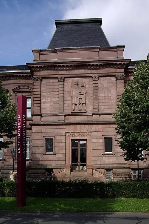
Rheinisches Landesmuseum Trier Berthold Werner · Public domain

Climate of Tarforst
Best months for sightseeingBest months for sightseeing: June–August.
This month · November
A cold month
Day 7° · Night 2° · Rain 81 mm
- Hottest month
- July (day 23°)
- Coldest month
- January (night -1°)
- Wettest month
- December (92 mm)
- Driest month
- April (58 mm)
Bars: average monthly low and high temperature. Below: precipitation. Monthly averages for 1970–2000 at about 18 km resolution, adjusted for elevation. Highlighted months are mild and relatively dry. Source: WorldClim 2.1 (CC BY 4.0).
Show values as a table
| Month | Jan | Feb | Mar | Apr | May | Jun | Jul | Aug | Sep | Oct | Nov | Dec |
|---|---|---|---|---|---|---|---|---|---|---|---|---|
| Average high (°C) | 3° | 5° | 9° | 12° | 17° | 20° | 23° | 23° | 18° | 13° | 7° | 4° |
| Average low (°C) | -1° | -1° | 1° | 4° | 8° | 11° | 13° | 12° | 9° | 6° | 2° | 0° |
| Precipitation (mm) | 78 | 65 | 71 | 58 | 72 | 74 | 74 | 61 | 68 | 79 | 81 | 92 |
How to get to Tarforst
The nearest airport is Luxembourg-Findel International Airport (LUX), 37 km to the west as the crow flies. The nearest large city is Trier, 4 km to the northwest.
Airports
- Luxembourg-Findel International Airport (LUX) Luxembourg 37 kmwest
- Frankfurt-Hahn Airport (HHN) Frankfurt am Main (Lautzenhausen) 47 kmnortheast
- Saarbrücken Airport (SCN) Saarbrücken 66 kmsoutheast
Nearby large cities
- Trier Population: 100.1K 4 kmnorthwest
- Saarbrücken Population: 183K 61 kmsouth
- Metz Population: 123.9K 79 kmsouthwest
- Koblenz Population: 107.3K 93 kmnortheast
- Bonn Population: 330.6K 114 kmnorth
Straight-line distances; road distances are longer. Airport data: OurAirports.
Day trips from Tarforst
Within 100 km: 398 historic and cultural sites, 2,995 natural sites, 741 lakes, rivers and coasts.
0–25 km194 places
- Sauer River 13 kmW
- Syre River 16 kmW
- Zoonenberg Mountain 11 kmN
- Steinkopf Mountain 23 kmE
25–60 km1,170 places
- Château de Berg Historic site 44 kmW
- Wiltz River 54 kmNW
- Schiebach River 60 kmNW
- Millebaach River 58 kmW
60–100 km2,770 places
- Lac de Nisramont Lake 86 kmNW
- Lac de Robertville Lake 88 kmNW
- Mont de la Tour de Coo Mountain 94 kmNW
- Montagne de Stockem Mountain 68 kmW
Straight-line distances.
Nearby attractions & nature
Everything nearby-
Petrisberg Mountain, Trier2 km NW
-
Sankt Georg Attraction, Trier2 km S
-
Rheinisches Landesmuseum Trier Museum, Trier3.6 km W
-
Fernmeldeturm Trier - Petrisberg Landmark, Trier2.4 km NW
-
Grüneberg Mountain, Trier3.7 km N
-
Amphitheater Trier Attraction, Trier3.1 km W
Other cities and towns in Trier
-
 Kürenz Neighbourhood, Trier3 km NW
-
Filsch Village, Trier1.3 km SE
-
Domäne Avelsbach Village, Trier1.5 km N
-
Neu-Kürenz Neighbourhood, Trier1.6 km N
-
Kernscheid Village, Trier2 km S
-
Mariahof Village, Trier2.7 km SW
Sources & licences
Data last updated: · 2 independent sources