Haschbach an der Glan
Located in Henschtal, Landkreis Kusel Coordinates: 49°27′59″ N 7°24′45″ E
- Elevation
- 240 m
- above sea level
- Local time
- UTC+01:00
- Europe/Berlin · UTC+01:00
- Airports
- SCN Saarbrücken Airport36 km
- HHN Frankfurt-Hahn Airport54 km
About Haschbach an der Glan
Haschbach an der Glan is a village. Location: Henschtal, Landkreis Kusel. Elevation: 240 m. The best months to visit are June–September. The nearest airport is Saarbrücken Airport (36 km). Nearby sights include Kirchberg and Rottersberg.
Photos of Haschbach an der Glan
-
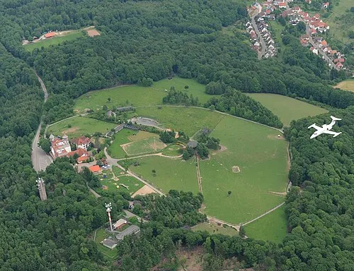
Potzberg U.S. Air Force photo by Airman 1st Class Caleb Pierce · Public domain -
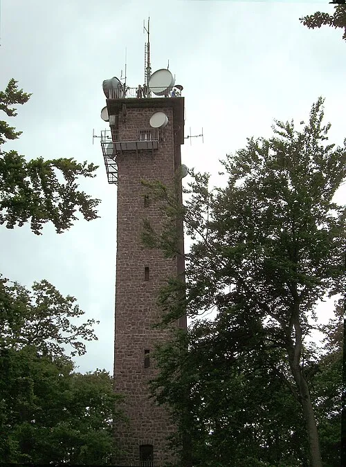
Potzbergturm EPei , reworked by Ralf Roletschek at de.wikipedia · CC BY-SA 3.0


Climate of Haschbach an der Glan
Best months for sightseeingBest months for sightseeing: June–September.
This month · November
A cold month
Day 8° · Night 2° · Rain 82 mm
- Hottest month
- July (day 24°)
- Coldest month
- February (night -2°)
- Wettest month
- December (93 mm)
- Driest month
- April (55 mm)
Bars: average monthly low and high temperature. Below: precipitation. Monthly averages for 1970–2000 at about 18 km resolution, adjusted for elevation. Highlighted months are mild and relatively dry. Source: WorldClim 2.1 (CC BY 4.0).
Show values as a table
| Month | Jan | Feb | Mar | Apr | May | Jun | Jul | Aug | Sep | Oct | Nov | Dec |
|---|---|---|---|---|---|---|---|---|---|---|---|---|
| Average high (°C) | 4° | 5° | 9° | 13° | 18° | 21° | 24° | 24° | 19° | 13° | 8° | 5° |
| Average low (°C) | -1° | -2° | 1° | 3° | 7° | 11° | 12° | 11° | 8° | 5° | 2° | 0° |
| Precipitation (mm) | 73 | 67 | 66 | 55 | 73 | 72 | 71 | 59 | 64 | 78 | 82 | 93 |
Other places to visit in this season: June July August September
How to get to Haschbach an der Glan
The nearest airport is Saarbrücken Airport (SCN), 36 km to the southwest as the crow flies. For international flights: Frankfurt-Hahn Airport (HHN) (54 km). The nearest large city is Saarbrücken, 39 km to the southwest.
Airports
- Saarbrücken Airport (SCN) Saarbrücken 36 kmsouthwest
- Frankfurt-Hahn Airport (HHN) Frankfurt am Main (Lautzenhausen) 54 kmnorth
- Mannheim-City Airport (MHG) Mannheim 80 kmeast
Nearby large cities
- Saarbrücken Population: 183K 39 kmsouthwest
- Trier Population: 100.1K 64 kmnorthwest
- Ludwigshafen am Rhein Population: 163.2K 75 kmeast
- Mannheim Population: 308K 76 kmeast
- Mainz Population: 222.9K 85 kmnortheast
Straight-line distances; road distances are longer. Airport data: OurAirports.
Day trips from Haschbach an der Glan
Within 100 km: 723 historic and cultural sites, 2,878 natural sites, 721 lakes, rivers and coasts.
0–25 km377 places
- Gelterswoog Lake 22 kmE
- Ottweiler Wingertsweier Lake 18 kmW
- Bomberg Mountain 21 kmW
- Ziegelberg Mountain 6 kmSW
25–60 km1,720 places
- Talsperre Nonnweiler Lake 35 kmNW
- Steinbachtalsperre Lake 37 kmN
- Bostalsee Lake 27 kmNW
- Zwieselkopf Mountain 43 kmSE
60–100 km2,225 places
- Sauer River 71 kmNW
- Our River 93 kmNW
- Eisch River 99 kmW
- Larochette Castle Historic site 93 kmNW
Straight-line distances.
Nearby attractions & nature
Everything nearby-
Kirchberg Mountain, Quirnbach/Pfalz1.1 km NW
-
Rottersberg Mountain, Glan-Münchweiler1.2 km E
-
Klopfberg Mountain, Börsborn1.2 km S
-
Steinern Mann Mountain, Quirnbach/Pfalz1.6 km NE
-
Stein Bach River, Rhineland-Palatinate1.3 km NE
-
Steinberg Mountain, Steinbach am Glan2.5 km SW
Sources & licences
Data last updated: