Liebertwolkwitz
Located in Leipzig, Kreisfreie Stadt Leipzig Coordinates: 51°16′56″ N 12°27′55″ E

- Elevation
- 148 m
- above sea level
- Local time
- UTC+01:00
- Europe/Berlin · UTC+01:00
- Airports
- LEJ Leipzig/Halle Airport22 km
- DRS Dresden Airport93 km
About Liebertwolkwitz
Liebertwolkwitz is a village. Location: Leipzig, Kreisfreie Stadt Leipzig. Elevation: 148 m.
Liebertwolkwitz (German pronunciation: [ˈliːbɛʁtˌvɔlkvɪts]) is an outlying settlement and locality of Leipzig on the city's south side. It contains the Galgenberg, the highest elevation in the Leipzig area. It was established in or before 1040. Before the local government boundary reform in 1999, it was an administratively independent municipality.
Source: Wikipedia · CC BY-SA 4.0
Photos of Liebertwolkwitz
-

Romzig · CC0 -

Gliwi · CC BY-SA 4.0 -

Kekslauch · CC BY-SA 4.0 -

Giorno2 · CC BY-SA 4.0 -
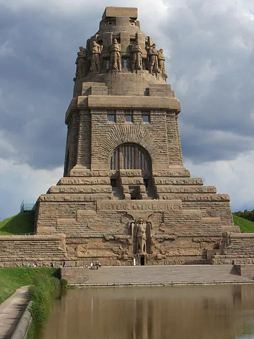
Monument to the Battle of the Nations Paolchen · CC BY-SA 3.0 de


Places bordering Liebertwolkwitz
- Meusdorf
Climate of Liebertwolkwitz
Best months for sightseeingBest months for sightseeing: May–September.
This month · November
A cold month
Day 8° · Night 2° · Rain 47 mm
- Hottest month
- July (day 24°)
- Coldest month
- January (night -2°)
- Wettest month
- July (75 mm)
- Driest month
- February (33 mm)
Bars: average monthly low and high temperature. Below: precipitation. Monthly averages for 1970–2000 at about 18 km resolution, adjusted for elevation. Highlighted months are mild and relatively dry. Source: WorldClim 2.1 (CC BY 4.0).
Show values as a table
| Month | Jan | Feb | Mar | Apr | May | Jun | Jul | Aug | Sep | Oct | Nov | Dec |
|---|---|---|---|---|---|---|---|---|---|---|---|---|
| Average high (°C) | 3° | 4° | 8° | 13° | 19° | 22° | 24° | 24° | 19° | 14° | 8° | 4° |
| Average low (°C) | -2° | -2° | 1° | 4° | 8° | 12° | 13° | 13° | 10° | 6° | 2° | -1° |
| Precipitation (mm) | 34 | 33 | 41 | 35 | 52 | 54 | 75 | 66 | 51 | 38 | 47 | 41 |
Other places to visit in this season: May June July August September
How to get to Liebertwolkwitz
The nearest airport is Leipzig/Halle Airport (LEJ), 22 km to the northwest as the crow flies. The nearest large city is Leipzig, 9 km to the northwest.
Airports
- Leipzig/Halle Airport (LEJ) Schkeuditz 22 kmnorthwest
- Dresden Airport (DRS) Dresden 93 kmeast
- Erfurt-Weimar Airport (ERF) Erfurt 111 kmwest
Nearby large cities
- Leipzig Population: 505K 9 kmnorthwest
- Halle Population: 237.9K 40 kmnorthwest
- Gera Population: 104.7K 52 kmsouthwest
- Chemnitz Population: 247.2K 59 kmsoutheast
- Jena Population: 104.7K 73 kmsouthwest
Straight-line distances; road distances are longer. Airport data: OurAirports.
Day trips from Liebertwolkwitz
Within 100 km: 518 historic and cultural sites, 2,182 natural sites, 641 lakes, rivers and coasts.
0–25 km223 places
- Speicherbecken Witznitz Lake 16 kmS
- Vogtlandsee Lake 21 kmN
- Herthasee Lake 20 kmE
- Großsteinberger See Lake 12 kmE
25–60 km651 places
- Sprotte River 38 kmS
- Rabeninsel Island 41 kmNW
- Langer Rodaer See Lake 29 kmE
- Talsperre Koberbach Lake 57 kmS
60–100 km2,467 places
- Buchenwald concentration camp Historic site 90 kmW
- Roda River 75 kmSW
- Roda River 76 kmSW
- Ehle River 95 kmNW
Straight-line distances.
Nearby attractions & nature
Everything nearby-
Galgenberg Mountain, Leipzig1.2 km W
-
Monarchenhügel Mountain, Leipzig2.3 km NW
-
Kolmberg Mountain, Leipzig2 km NE
-
Monument to the Battle of the Nations Landmark, Leipzig4.9 km NW
-
Leipzig, Pfarrkirche Holzhausen Attraction, Leipzig3 km N
-
Steinberg Mountain, Leipzig4 km N
Other cities and towns in Leipzig
-
Reudnitz-Thonberg Village, Leipzig7 km NW
-
 Connewitz Neighbourhood, Leipzig6.8 km NW
-
Dösen Village, Leipzig3.9 km W
-
 Baalsdorf Village, Leipzig4.7 km N
-
Stötteritz Neighbourhood, Leipzig4.9 km NW
-
 Lößnig Neighbourhood, Leipzig5.2 km W
Sources & licences
Data last updated: · 2 independent sources