Großer Gleichberg
Located in Römhild, Landkreis Hildburghausen Coordinates: 50°23′18″ N 10°35′28″ E
- Elevation
- 679 m
- above sea level
- Local time
- UTC+01:00
- Europe/Berlin · UTC+01:00
- Airports
- ERF Erfurt-Weimar Airport71 km
- NUE Nuremberg Airport105 km
About Großer Gleichberg
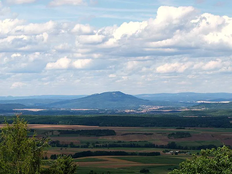
Großer Gleichberg is a mountain. Location: Römhild, Landkreis Hildburghausen. Elevation: 679 m.
At 679 m above sea level (NHN), the Großer Gleichberg is the higher of the two adjacent mountaintops known as the Gleichberge east of Römhild in the landscape of Grabfeld and the county of Hildburghausen in the German state of Thuringia. It was formed in the Tertiary volcanic field of the Heldburger Gangschar and is the highest point today of that formation.
Source: Wikipedia · CC BY-SA 4.0
At a glance
- Topographic prominence
- 276 m
Source: Wikidata
Climate of Großer Gleichberg
Best months for sightseeingBest months for sightseeing: June–August.
This month · November
A cold month
Day 4° · Night -2° · Rain 64 mm
- Hottest month
- July (day 21°)
- Coldest month
- February (night -6°)
- Wettest month
- July (81 mm)
- Driest month
- February (50 mm)
Bars: average monthly low and high temperature. Below: precipitation. Monthly averages for 1970–2000 at about 18 km resolution, adjusted for elevation. Highlighted months are mild and relatively dry. Source: WorldClim 2.1 (CC BY 4.0).
Show values as a table
| Month | Jan | Feb | Mar | Apr | May | Jun | Jul | Aug | Sep | Oct | Nov | Dec |
|---|---|---|---|---|---|---|---|---|---|---|---|---|
| Average high (°C) | 0° | 1° | 6° | 10° | 16° | 18° | 21° | 21° | 16° | 10° | 4° | 1° |
| Average low (°C) | -5° | -6° | -2° | 0° | 5° | 8° | 10° | 9° | 6° | 2° | -2° | -4° |
| Precipitation (mm) | 61 | 50 | 57 | 50 | 61 | 68 | 81 | 62 | 60 | 59 | 64 | 75 |
How to get to Großer Gleichberg
The nearest airport is Erfurt-Weimar Airport (ERF), 71 km to the north as the crow flies. The nearest large city is Erfurt, 73 km to the northeast.
Airports
- Erfurt-Weimar Airport (ERF) Erfurt 71 kmnorth
- Nuremberg Airport (NUE) Nuremberg 105 kmsouth
- Kassel Airport (KSF) Calden 142 kmnorthwest
Nearby large cities
- Erfurt Population: 218.8K 73 kmnortheast
- Würzburg Population: 133.7K 80 kmsouthwest
- Jena Population: 104.7K 93 kmnortheast
- Erlangen Population: 102.7K 94 kmsouth
- Fürth Population: 132K 105 kmsouth
Straight-line distances; road distances are longer. Airport data: OurAirports.
Nearest towns and villages
-
Gleichamberg Village, Römhild2 km S
-
Römhild Village, Römhild3.8 km W
-
Milz Village, Römhild4 km W
-
Roth Village, Römhild2.6 km E
-
Hindfeld Village, Römhild3 km SW
-
Dingsleben Village, Landkreis Hildburghausen5 km N
Nearby attractions & nature
Everything nearby-
Röther Kopf Mountain, Römhild1.3 km NE
-
 Kleiner Gleichberg Mountain, Römhild2.5 km N
-
Altenburg Mountain, Römhild1.6 km W
-
Hartenburg Mountain, Römhild2.2 km NW
-
Linhartzberg Mountain, Römhild2.4 km SE
-
Kleeberg Mountain, Römhild2.5 km NE
-
Schäferberg Mountain, Römhild2.9 km NW
-
Gleichberg Mountain, Dingsleben3.2 km N
Sources & licences
Data last updated: · 2 independent sources