- Population
- 110
- 110
- Elevation
- 243 m
- above sea level
- Local time
- UTC+02:00
- Europe/Athens · UTC+02:00
- Airports
- KLX Kalamata Airport52 km
- ZTH Zakynthos International Airport "Dionysios Solomos"178 km
About Myrsíni
Myrsíni is a village. Location: East Mani, Laconia. Population: 110. Elevation: 243 m. The best months to visit are May, September–October. The nearest airport is Kalamata Airport (52 km). Nearby sights include Agia Varvara and Stoupa beach.
Climate of Myrsíni
Best months for sightseeingBest months for sightseeing: May, September–October.
This month · November
A wet month
Day 17° · Night 10° · Rain 115 mm
- Hottest month
- July (day 30°)
- Coldest month
- January (night 6°)
- Wettest month
- December (124 mm)
- Driest month
- June (8 mm)
Bars: average monthly low and high temperature. Below: precipitation. Monthly averages for 1970–2000 at about 18 km resolution, adjusted for elevation. Highlighted months are mild and relatively dry. Source: WorldClim 2.1 (CC BY 4.0).
Show values as a table
| Month | Jan | Feb | Mar | Apr | May | Jun | Jul | Aug | Sep | Oct | Nov | Dec |
|---|---|---|---|---|---|---|---|---|---|---|---|---|
| Average high (°C) | 12° | 13° | 15° | 18° | 23° | 28° | 30° | 30° | 27° | 22° | 17° | 14° |
| Average low (°C) | 6° | 6° | 7° | 10° | 14° | 18° | 20° | 20° | 17° | 14° | 10° | 8° |
| Precipitation (mm) | 107 | 93 | 71 | 51 | 22 | 8 | 8 | 11 | 21 | 74 | 115 | 124 |
How to get to Myrsíni
The nearest airport is Kalamata Airport (KLX), 52 km to the northwest as the crow flies. For international flights: Zakynthos International Airport "Dionysios Solomos" (ZTH) (178 km). The nearest large city is Piraeus, 170 km to the northeast.
Airports
- Kalamata Airport (KLX) Kalamata 52 kmnorthwest
- Zakynthos International Airport "Dionysios Solomos" (ZTH) Zakynthos 178 kmnorthwest
- Patras Araxos Agamemnon Airport (GPA) Patras 180 kmnorthwest
Nearby large cities
- Piraeus Population: 163.7K 170 kmnortheast
- Athens Population: 664K 178 kmnortheast
Straight-line distances; road distances are longer. Airport data: OurAirports.
Day trips from Myrsíni
Within 100 km: 18 historic and cultural sites, 1 natural site, 20 lakes, rivers and coasts.
0–25 km7 places
- Kalogria beach Beach 20 kmNW
- Foneas beach Beach 22 kmNW
- Delphinia beach Beach 22 kmNW
- Agia Varvara Attraction 11 kmSE
25–60 km19 places
- Moni Gardikiou Attraction 52 kmNW
- Moní Velanidiás Attraction 46 kmNW
- Moni Dimiovis Attraction 39 kmNW
- Moni Profiti Ioil Attraction 43 kmNW
60–100 km13 places
- Moni Voulkanou Attraction 65 kmNW
- Moní Agíon Pánton Attraction 84 kmNE
- Ierá Moní Agíou Nikoláou Kaltezón Attraction 64 kmN
- Moni Ambelaki Attraction 61 kmN
Straight-line distances.
Nearby attractions & nature
Everything nearby-
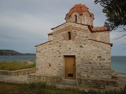 Agia Varvara Attraction, East Mani11 km SE
-
Stoupa beach Beach, Peloponnese20 km NW
-
Kalogria beach Beach, Peloponnese20 km NW
-
Delphinia beach Beach, Peloponnese22 km NW
-
Foneas beach Beach, West Mani22 km NW
-
Moni Golas Attraction, Sparti20 km N
Sources & licences
Data last updated: