- Population
- 12,717
- 12.7K
- Elevation
- 16 m
- above sea level
- Local time
- UTC+02:00
- Europe/Athens · UTC+02:00
- Airports
- RHO Rhodes International Airport "Diagoras"6 km
- DLM Dalaman International Airport66 km
About Ialysos
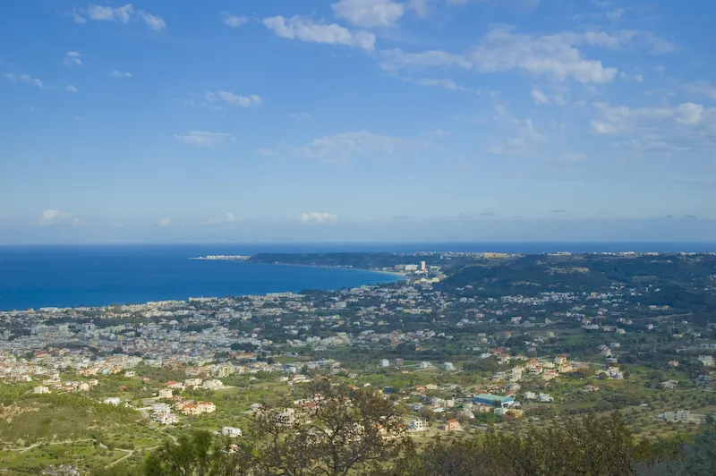
Ialysos is a town. Location: Rhodes, Dodecanese. Population: 12,717. Elevation: 16 m.
Ialysos (Greek: Ιαλυσός, before 1976: Τριάντα Trianta) is a town and a former municipality on the island of Rhodes, in the Dodecanese, Greece. Since the 2011 local government reform it is part of the municipality Rhodes, of which it is a municipal unit. The municipal unit has an area of 16.7 km2. It is the second-largest town on the island of Rhodes, having a population of approximately 13,000.
Source: Wikipedia · CC BY-SA 4.0
Photos of Ialysos
-

Mitroshk · CC BY 3.0 -

Mitroshk · CC BY 3.0 -

Mitroshk · CC BY 3.0 -

Mitroshk · CC BY 3.0 -

Mitroshk · CC BY 3.0


Travel notes for Ialysos
From Wikivoyage
Ialysos is a city in Rhodes. It includes Ixia, a seaside resort village.
Understand+
Ialysos is the second-largest town on the island of Rhodes. It has a population of approximately 12,000, and is located 8 km west of the town of Rhodes, the island's capital, on the island's northwestern coast. Blue waters, a seemingly endless organized beach, the pleasant cool summer climate and mild winters, big hotel complexes and smaller friendly ones, shops of all kinds, and many night-clubs all contribute to make lalysos bay one of the most popular resorts on the island. Thanks to the ideal conditions of the region, important international windsurfing competitions often take place here.
The beaches have a mixture of sand and pebbles. It is a favourite spot for windsurfers with two water sports centres renting boards and jet-skis.
Ixia has a long narrow beach which is situated near the main road with many small shops, commercial centres, restaurants, cafes and hotels lining the beach strip. The area is popular with tourists.
Get in+
The Rhodes International Airport (RHO IATA) or Diagoras International Airport. "Diagoras" (Greek: Κρατικός Αερολιμένας Ρόδου, "Διαγόρας") is 14 km to the south west of Ixia. Paradisi and Theologos (Tholos) lies a few kilometres further down the coast and past the airport.
Source: Wikivoyage · CC BY-SA 4.0 · abridged
Population of Ialysos over time
| 1951 | 2,822 | |
|---|---|---|
| 1991 | 6,967 | |
| 2001 | 10,111 | |
| 2011 | 11,331 | |
| 2021 | 12,717 |
Censuses and official estimates; source: Wikidata.
Climate of Ialysos
Best months for sightseeingBest months for sightseeing: April–May, October.
This month · November
A wet month
Day 20° · Night 14° · Rain 101 mm
- Hottest month
- July (day 31°)
- Coldest month
- February (night 9°)
- Wettest month
- January (154 mm)
- Driest month
- July (1 mm)
Bars: average monthly low and high temperature. Below: precipitation. Monthly averages for 1970–2000 at about 18 km resolution, adjusted for elevation. Highlighted months are mild and relatively dry. Source: WorldClim 2.1 (CC BY 4.0).
Show values as a table
| Month | Jan | Feb | Mar | Apr | May | Jun | Jul | Aug | Sep | Oct | Nov | Dec |
|---|---|---|---|---|---|---|---|---|---|---|---|---|
| Average high (°C) | 15° | 15° | 17° | 20° | 25° | 29° | 31° | 31° | 29° | 25° | 20° | 17° |
| Average low (°C) | 9° | 9° | 10° | 13° | 16° | 20° | 23° | 23° | 21° | 17° | 14° | 11° |
| Precipitation (mm) | 154 | 126 | 81 | 35 | 20 | 6 | 1 | 2 | 7 | 69 | 101 | 146 |
How to get to Ialysos
The nearest airport is Rhodes International Airport "Diagoras" (RHO), 6 km to the west as the crow flies. The nearest large city is Aydin, 161 km to the north.
Airports
- Rhodes International Airport "Diagoras" (RHO) Rhodes 6 kmwest
- Dalaman International Airport (DLM) Dalaman 66 kmnortheast
- Milas Bodrum International Airport (BJV) Bodrum 103 kmnorthwest
Nearby large cities
- Aydin Population: 163K 161 kmnorth
- Nazilli Population: 119.4K 167 kmnorth
- Denizli Population: 313.2K 172 kmnortheast
- Merkezefendi Population: 280.3K 173 kmnortheast
- Salihli Population: 119.3K 230 kmnorth
Straight-line distances; road distances are longer. Airport data: OurAirports.
Day trips from Ialysos
Within 100 km: 45 historic and cultural sites, 219 natural sites, 162 lakes, rivers and coasts.
0–25 km14 places
- Kızılada Island 21 kmN
- Çatal Adaları Island 20 kmNW
- Suluca Adası Island 25 kmN
- Taşlıca Adası Island 24 kmN
25–60 km172 places
- Uzunyalı Plajı Beach 49 kmN
- Taşlık Plajı Beach 54 kmNW
- Kumluk Plajı Beach 54 kmNW
- Hastanealtı Plajı Beach 54 kmNW
60–100 km240 places
- Çalış Beach Beach 90 kmE
- Gümbet Plajı Beach 96 kmNW
- Bardakçı Plajı Beach 95 kmNW
- Paşatarlası Plajı Beach 93 kmNW
Straight-line distances.
Nearby attractions & nature
Everything nearby-
Çatal Dağı Mountain, Marmaris21 km NW
-
Karayüksekdağ Mountain, Marmaris22 km N
-
Karayüksekdağ Mountain, Marmaris22 km N
-
Karabağ Tepesi Mountain, Marmaris22 km NW
-
Asar Dağı Mountain, Marmaris23 km NW
-
Karayüksekdağ Mountain, Marmaris25 km NW
-
Loryma Historic site, Marmaris23 km NW
-
Bozburun Yarımadası Natural site, Muğla Province24 km NW
Other cities and towns in Rhodes
-
 Faliraki Town, Rhodes9.1 km SE
-
Afántou Town, Rhodes13 km S
-
 Archangelos Town, Rhodes22 km S
Sources & licences
Data last updated: · 2 independent sources