- Population
- 19,793
- 19.8K
- Elevation
- 104 m
- above sea level
- Local time
- UTC+02:00
- Europe/Athens · UTC+02:00
- Places inside
- 19
- listed under Syros
- Airports
- JMK Mykonos Island National Airport38 km
- ATH Athens Eleftherios Venizelos International Airport103 km
About Syros
Syros is a municipality. Location: Nomós Kykládon, South Aegean. Population: 19,793. Elevation: 104 m. The best months to visit are May, September–October. The nearest airport is Mykonos Island National Airport (38 km). Nearby sights include Kini beach and Delphini Beach.
Climate of Syros
Best months for sightseeingBest months for sightseeing: May, September–October.
This month · November
Outside the best season
Day 18° · Night 14° · Rain 60 mm
- Hottest month
- July (day 29°)
- Coldest month
- February (night 10°)
- Wettest month
- December (71 mm)
- Driest month
- July (2 mm)
Bars: average monthly low and high temperature. Below: precipitation. Monthly averages for 1970–2000 at about 18 km resolution, adjusted for elevation. Highlighted months are mild and relatively dry. Source: WorldClim 2.1 (CC BY 4.0).
Show values as a table
| Month | Jan | Feb | Mar | Apr | May | Jun | Jul | Aug | Sep | Oct | Nov | Dec |
|---|---|---|---|---|---|---|---|---|---|---|---|---|
| Average high (°C) | 13° | 13° | 15° | 18° | 23° | 27° | 29° | 29° | 26° | 22° | 18° | 15° |
| Average low (°C) | 10° | 10° | 11° | 14° | 18° | 22° | 25° | 25° | 21° | 18° | 14° | 11° |
| Precipitation (mm) | 68 | 61 | 51 | 23 | 12 | 4 | 2 | 3 | 6 | 40 | 60 | 71 |
How to get to Syros
The nearest airport is Mykonos Island National Airport (JMK), 38 km to the east as the crow flies. For international flights: Athens Eleftherios Venizelos International Airport (ATH) (103 km). The nearest large city is Athens, 122 km to the northwest.
Airports
- Mykonos Island National Airport (JMK) Mykonos 38 kmeast
- Athens Eleftherios Venizelos International Airport (ATH) Spata-Artemida 103 kmnorthwest
- Santorini International Airport (JTR) Santorini Island 124 kmsoutheast
Nearby large cities
- Athens Population: 664K 122 kmnorthwest
- Piraeus Population: 163.7K 126 kmnorthwest
- Konak Population: 332.3K 220 kmnortheast
- Karabağlar Population: 479.3K 222 kmnortheast
- Çiğli Population: 214.1K 223 kmnortheast
Straight-line distances; road distances are longer. Airport data: OurAirports.
Day trips from Syros
Within 100 km: 14 historic and cultural sites, 2 natural sites, 51 lakes, rivers and coasts.
0–25 km23 places
- Ampela beach Beach 6 kmS
- Fetouri beach Beach 5 kmSW
- Foinikas beach Beach 5 kmSW
- Kokkina beach Beach 5 kmSW
25–60 km28 places
- Cyclades Island 31 kmS
- Moni Agiou Arseniou Attraction 46 kmSE
- Aghios Prokopios beach Beach 55 kmSE
- Grotta beach Beach 54 kmSE
60–100 km16 places
- Agiassos beach Beach 68 kmSE
- Lionas beach Beach 68 kmSE
- Nisída Kopriá Island 81 kmSE
- Nisída Megali Plaka Island 88 kmSE
Straight-line distances.
Places in Syros
19 placesBar: population relative to the most populous place in this list.
Lakes, rivers & coasts9
- Ampela beach · Beach
- Armeos Beach · Beach
- Asteria beach · Beach
- Axladi beach · Beach
- Azolimnos beach · Beach
- Galissas Beach · Beach
- Kimata beach · Beach
- Lotos beach · Beach
- Vari beach · Beach
Heritage & sights6
- Agia Paraskevi · Attraction
- Agios Georgios · Attraction
- Agios Sevastianos · Attraction
- Church of Transfiguration · Attraction
- Naos Kimiseos Theotokou · Attraction
- Panagia Faneromeni · Attraction
Nearby attractions & nature
Everything nearby-
Kini beach Beach, South Aegean2.5 km NW
-
Delphini Beach Beach, South Aegean3.8 km NW
-
Foinikas beach Beach, South Aegean4.5 km SW
-
Fetouri beach Beach, South Aegean5 km SW
-
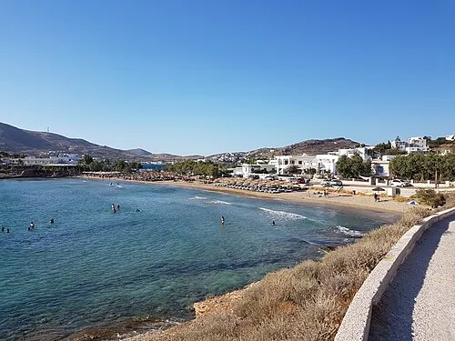 Agathopes Beach Beach, South Aegean5.6 km SW
-
Megas Gialos beach Beach, South Aegean5.4 km S
-
Kokkina beach Beach, South Aegean5.4 km SW
-
Komito beach Beach, South Aegean6.3 km SW
Sources & licences
Data last updated: