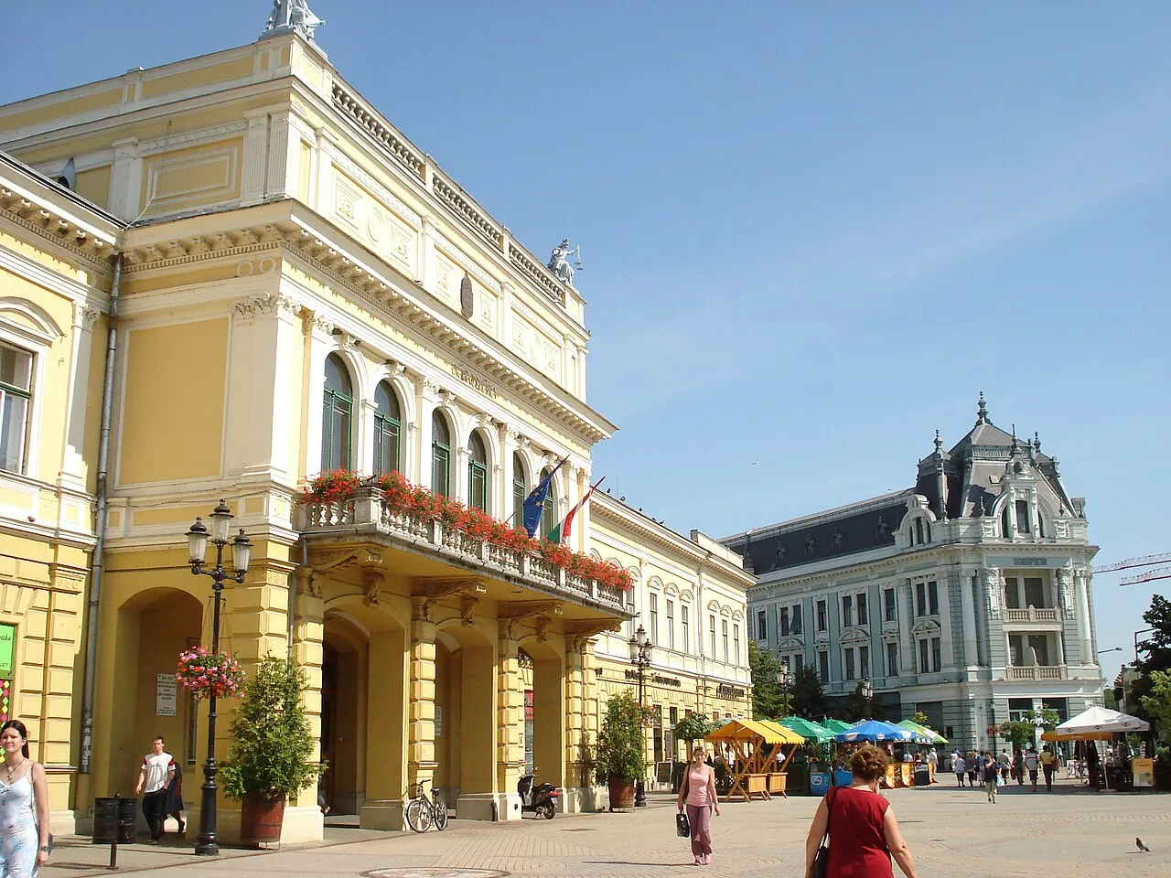
- Population
- 117,689
- 117.7K
- Elevation
- 111 m
- above sea level
- Local time
- UTC+01:00
- Europe/Budapest · UTC+01:00
- Airports
- DEB Debrecen International Airport52 km
- KSC Košice International Airport86 km
About Nyíregyháza
Nyíregyháza is a city. Location: Szabolcs-Szatmár-Bereg, Hungary. Population: 117,689. Elevation: 111 m.
Nyíregyháza (Hungarian: [ˈɲiːrɛchaːzɒ] , Slovak: Níreďháza [ˈɲiːrɛɟɦaːza]) is a city with county rights in northeastern Hungary and the county capital of Szabolcs-Szatmár-Bereg. With a population of 118,001, it is the seventh-largest city in Hungary and the second largest in the Northern Great Plain region. Its development has been ongoing since the 18th century, making it the economic and cultural center of the region. Nyíregyháza Zoo, with over 500 species, is recognized throughout Europe.
Source: Wikipedia · CC BY-SA 4.0
Photos of Nyíregyháza
-

Fortepan — ID 92463 : Adományozó/Donor: Unknown. archive copy at the Wayback Machine · Public domain -

Fortepan — ID 1306 : Adományozó/Donor: Kádas Tibor · CC BY-SA 3.0 -

Fortepan — ID 1291 : Adományozó/Donor: Kádas Tibor · CC BY-SA 3.0 -

Fortepan — ID 57805 : Adományozó/Donor: Pálinkás Zsolt. archive copy at the Wayback Machine · CC BY-SA 3.0 -

Fortepan — ID 6038 : Adományozó/Donor: Gyöngyi · CC BY-SA 3.0


Travel notes for Nyíregyháza
From Wikivoyage
Nyíregyháza is the county seat and largest city in Szabolcs-Szatmár-Bereg county in Eastern Hungary.
Understand+
Some of the most popular attractions can be found north of the city in the suburb of Sóstó. The city is mostly looked over by American and British tourists, though often visited by Polish, Ukrainian, Romanian, and certainly Hungarian visitors.
1 Tourist Information Centre (Turisztikai Információs Központ TDM Iroda), Kossuth tér 1. (Center), ☏ +36 42 310-735, fax: +36 42 310-735, tdm@nyiregyhaza.info.hu. Mon-Fri 09:00-17:00.
2 Tourinform Sóstó Thermal Bath (Tourinform - Sóstógyógyfürdő), Nyíregyháza-Sóstó Thermal Bath, Water Tower,Sóstói road ~75 (North), ☏ +36 42 411-193, sostofurdo@tourinform.hu. Jun 15-Sep 15: Mon-Fri 09:00-17:00, Sat Sun 09:00-13:00.
Get in+
By bus:
1 Bus Station (Autóbuszállomás), Petőfi tér (200 m north of train station), ☏ +36 42 598177. More direct lines:Eger (2-3 per day), Fehérgyarmat (four per day), Kisvárda (four per day, 1 hr 25 min), Mátészalka (every half hour until ~19:00, 1½ hr), Miskolc (2-3 per day), Nyírbátor (16 or more per day), Sárospatak (one morning, one afternoon), Tokaj (one morning, one afternoon), Vásárosnamény (16+ per day, 1hr 18min). Tiszafüred (Tisza Lake) via Debrecen (four per day).
By train:
2 Train Station (Nyíregyháza Vasútállomás). Direct international service to Kyiv, Lviv, and Moscow. - Trains leave from both the Budapest Nyugati and Keleti stations (hourly, Ft 5200, 2nd cl., three hours ). With InterCity You will have to pay an additional fee for your seat reservation (automatically issued at the ticket counter), but the limited seats may disappear quickly, especially on weekends when many students are travelling to and from the capital. InterCity trains run either through Debrecen (hourly, Ft 1100, ~30 min) or Miskolc (hourly until 23:00, ~Ft 1900, 1 hour). Szolnok (hourly until 23:00, ~Ft 3700, 2 hours). Mátészalka: there are a couple of direct trains, but buses better (prices 2nd cl., IC, 2014). Timetable
If you choose not to take an InterCity to Budapest, the journey will last closer to 4 hours as the train makes more stops. The train also will likely be less clean and less comfortable.
By car:
M3 motorway connects Nyíregyháza directly to Budapest. Otherwise from Polgár take route #36. From Miskolc take #37 to #38. From Debrecen take route #4.
By taxi
There are three main two companies in the city: Bolt taxi , Szabolcs Taxi , they both have applications as well.
Source: Wikivoyage · CC BY-SA 4.0 · abridged
Twin towns and sister cities of Nyíregyháza
- Satu Mare· Romania
- Kajaani· Finland
- Prešov· Slovakia
- St Albans· United Kingdom
Source: Wikidata. Only places with a page on this site are shown.
Population of Nyíregyháza over time
| 2013 | 118,185 | |
|---|---|---|
| 2014 | 118,164 | |
| 2021 | 116,554 | |
| 2022 | 116,282 | |
| 2023 | 115,711 | |
| 2024 | 115,359 | |
| 2025 | 114,873 | |
| 2026 | 114,096 |
Censuses and official estimates; source: Wikidata.
Climate of Nyíregyháza
Best months for sightseeingBest months for sightseeing: May–September.
This month · November
A cold month
Day 8° · Night 0° · Rain 41 mm
- Hottest month
- July (day 26°)
- Coldest month
- January (night -5°)
- Wettest month
- July (67 mm)
- Driest month
- January (26 mm)
Bars: average monthly low and high temperature. Below: precipitation. Monthly averages for 1970–2000 at about 18 km resolution, adjusted for elevation. Highlighted months are mild and relatively dry. Source: WorldClim 2.1 (CC BY 4.0).
Show values as a table
| Month | Jan | Feb | Mar | Apr | May | Jun | Jul | Aug | Sep | Oct | Nov | Dec |
|---|---|---|---|---|---|---|---|---|---|---|---|---|
| Average high (°C) | 1° | 4° | 10° | 17° | 22° | 25° | 26° | 26° | 21° | 15° | 8° | 3° |
| Average low (°C) | -5° | -4° | 0° | 5° | 10° | 13° | 14° | 14° | 10° | 5° | 0° | -3° |
| Precipitation (mm) | 26 | 26 | 29 | 43 | 56 | 64 | 67 | 53 | 45 | 33 | 41 | 38 |
Other places to visit in this season: May June July August September
How to get to Nyíregyháza
The nearest airport is Debrecen International Airport (DEB), 52 km to the south as the crow flies. The nearest large city is Debrecen, 48 km to the south.
Airports
- Debrecen International Airport (DEB) Debrecen 52 kmsouth
- Košice International Airport (KSC) Košice 86 kmnorthwest
- Satu Mare International Airport (SUJ) Satu Mare 92 kmeast
Nearby large cities
- Debrecen Population: 202.4K 48 kmsouth
- Miskolc Population: 154.5K 72 kmwest
- Satu Mare Population: 112.5K 87 kmeast
- Košice Population: 225K 91 kmnorth
- Oradea Population: 183.1K 102 kmsouth
Straight-line distances; road distances are longer. Airport data: OurAirports.
Day trips from Nyíregyháza
Within 100 km: 25 historic and cultural sites, 23 natural sites, 6 lakes, rivers and coasts.
0–25 km4 places
- Tetemhegy Mountain 13 kmNE
- Szincsehalom Mountain 21 kmN
- Hajdúdorog Ghetto Historic site 22 kmSW
- Nyíregyháza Ghetto Historic site 1 kmS
25–60 km15 places
- Ondava River 56 kmN
- Zabarla Mountain 52 kmNW
- Szeles Mountain 59 kmW
- Magoska Mountain 54 kmNW
60–100 km35 places
- Zemplínska šírava Lake 95 kmN
- Slanské Pohorie Mountain 97 kmN
- Torysa River 81 kmN
- Topľa River 88 kmN
Straight-line distances.
Nyíregyháza and similar cities
Side by side with cities of similar size in the same country: population, elevation and climate.
| Measure | Nyíregyháza | Kecskemét | Győr | Székesfehérvár |
|---|---|---|---|---|
| Population | 117.7K | 109.8K | 129.3K | 101.6K |
| Elevation | 111 m | 120 m | 122 m | 117 m |
| Summer day (hottest month) | 26° | 27° | 26° | 27° |
| Winter night (coldest month) | -5° | -4° | -3° | -3° |
| Annual rainfall | 521 mm | 522 mm | 538 mm | 538 mm |
| Best months | May–Sep | May–Sep | May–Sep | May–Sep |
| Distance | — | 192 km | 307 km | 263 km |
Climate values are 1970–2000 monthly averages; straight-line distance.
Nearby attractions & nature
Everything nearby-
Nyíregyháza Ghetto Historic site, Szabolcs-Szatmár-Bereg0.6 km S
-
Tetemhegy Mountain, Szabolcs-Szatmár-Bereg13 km NE
-
Szincsehalom Mountain, Szabolcs-Szatmár-Bereg21 km N
-
Hajdúdorog Ghetto Historic site, Hajdú-Bihar22 km SW
Other cities and towns in Szabolcs-Szatmár-Bereg
Sources & licences
Data last updated: · 2 independent sources