Crinstown Cross Roads
Located in County Kildare, Leinster Coordinates: 53°22′04″ N 6°37′16″ W
- Elevation
- 67 m
- above sea level
- Local time
- UTC+00:00
- Europe/Dublin · UTC+00:00
- Airports
- DUB Dublin Airport25 km
- BFS Belfast International Airport146 km
About Crinstown Cross Roads
Crinstown Cross Roads is a village. Location: County Kildare, Leinster. Elevation: 67 m. The best months to visit are June–September. The nearest airport is Dublin Airport (25 km). Nearby sights include Lyreen River and Baltracey River.
Photos of Crinstown Cross Roads
-
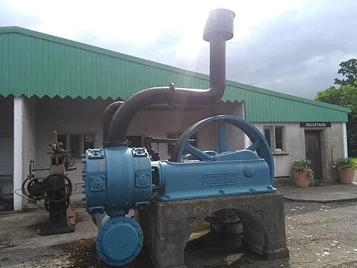
The Steam Museum Sheila1988 · CC0

Climate of Crinstown Cross Roads
Best months for sightseeingBest months for sightseeing: June–September.
This month · November
A cold month
Day 10° · Night 4° · Rain 82 mm
- Hottest month
- July (day 19°)
- Coldest month
- January (night 2°)
- Wettest month
- October (89 mm)
- Driest month
- April (56 mm)
Bars: average monthly low and high temperature. Below: precipitation. Monthly averages for 1970–2000 at about 18 km resolution, adjusted for elevation. Highlighted months are mild and relatively dry. Source: WorldClim 2.1 (CC BY 4.0).
Show values as a table
| Month | Jan | Feb | Mar | Apr | May | Jun | Jul | Aug | Sep | Oct | Nov | Dec |
|---|---|---|---|---|---|---|---|---|---|---|---|---|
| Average high (°C) | 8° | 8° | 10° | 12° | 15° | 17° | 19° | 19° | 17° | 14° | 10° | 8° |
| Average low (°C) | 2° | 2° | 3° | 4° | 6° | 9° | 11° | 11° | 9° | 7° | 4° | 3° |
| Precipitation (mm) | 86 | 67 | 65 | 56 | 59 | 61 | 61 | 76 | 77 | 89 | 82 | 86 |
Other places to visit in this season: June July August September
How to get to Crinstown Cross Roads
The nearest airport is Dublin Airport (DUB), 25 km to the east as the crow flies. The nearest large city is Dublin, 25 km to the east.
Airports
- Dublin Airport (DUB) Dublin 25 kmeast
- Belfast International Airport (BFS) Belfast 146 kmnorth
- George Best Belfast City Airport (BHD) Belfast 148 kmnorth
Nearby large cities
- Dublin Population: 1M 25 kmeast
- Belfast Population: 348K 144 kmnorth
- Limerick Population: 102.3K 155 kmsouthwest
- Cork Population: 224K 206 kmsouthwest
- Birkenhead Population: 325.3K 240 kmeast
Straight-line distances; road distances are longer. Airport data: OurAirports.
Day trips from Crinstown Cross Roads
Within 100 km: 319 historic and cultural sites, 535 natural sites, 544 lakes, rivers and coasts.
0–25 km117 places
- Rathmines and Rathgar Waterworks Lake 23 kmSE
- Hill of Tara Mountain 24 kmN
- Hill of Allen Mountain 22 kmSW
- Crockberry Hill Mountain 14 kmW
25–60 km553 places
- Wicklow Mountains Mountain 37 kmSE
- Rockabill Island 48 kmNE
- Pollboy Bridge Landmark 32 kmN
- Sandymount Strand Beach 28 kmE
60–100 km728 places
- Long Island Island 86 kmW
- Inchmore Island 80 kmNW
- Inchmore Island 88 kmW
- Inchcleraun Island 95 kmW
Straight-line distances.
Nearby attractions & nature
Everything nearby-
Lyreen River River, County Kildare1.7 km N
-
Baltracey River River, County Kildare2.9 km W
-
Pickering Forest Natural site, County Kildare3.8 km SE
-
Conolly's Folly Landmark, County Kildare4.1 km E
-
The Steam Museum Museum, County Kildare6.4 km S
-
Saint Patrick’s Hill Mountain, County Kildare5.2 km SE
Sources & licences
Data last updated: