- Elevation
- 79 m
- above sea level
- Local time
- UTC+00:00
- Europe/Dublin · UTC+00:00
- Airports
- ORK Cork International Airport28 km
- KIR Kerry Airport107 km
About Churchtown
Churchtown is a village. Location: County Cork, Munster. Elevation: 79 m. The best months to visit are June–September. The nearest airport is Cork International Airport (28 km). Nearby sights include Ballyandreen Bay and Ballycroneen Bay.
Climate of Churchtown
Best months for sightseeingBest months for sightseeing: June–September.
This month · November
A wet month
Day 10° · Night 5° · Rain 111 mm
- Hottest month
- July (day 19°)
- Coldest month
- January (night 3°)
- Wettest month
- January (126 mm)
- Driest month
- April (56 mm)
Bars: average monthly low and high temperature. Below: precipitation. Monthly averages for 1970–2000 at about 18 km resolution, adjusted for elevation. Highlighted months are mild and relatively dry. Source: WorldClim 2.1 (CC BY 4.0).
Show values as a table
| Month | Jan | Feb | Mar | Apr | May | Jun | Jul | Aug | Sep | Oct | Nov | Dec |
|---|---|---|---|---|---|---|---|---|---|---|---|---|
| Average high (°C) | 8° | 8° | 10° | 12° | 15° | 17° | 19° | 19° | 17° | 14° | 10° | 8° |
| Average low (°C) | 3° | 3° | 4° | 5° | 7° | 10° | 11° | 11° | 10° | 7° | 5° | 4° |
| Precipitation (mm) | 126 | 105 | 98 | 56 | 61 | 56 | 62 | 73 | 85 | 122 | 111 | 126 |
Other places to visit in this season: June July August September
How to get to Churchtown
The nearest airport is Cork International Airport (ORK), 28 km to the west as the crow flies. The nearest large city is Cork, 28 km to the west.
Airports
- Cork International Airport (ORK) Cork 28 kmwest
- Kerry Airport (KIR) Farranfore 107 kmwest
- Shannon Airport (SNN) Shannon 113 kmnorthwest
Nearby large cities
- Cork Population: 224K 28 kmwest
- Limerick Population: 102.3K 100 kmnorth
- Dublin Population: 1M 208 kmnortheast
- Swansea Population: 300.4K 287 kmeast
- Plymouth Population: 260.2K 320 kmsoutheast
Straight-line distances; road distances are longer. Airport data: OurAirports.
Day trips from Churchtown
Within 100 km: 128 historic and cultural sites, 630 natural sites, 376 lakes, rivers and coasts.
0–25 km93 places
- Rocky Island Island 15 kmW
- Ringaskiddy Island Island 16 kmW
- Little Island Island 22 kmW
- Haulbowline Island Island 15 kmW
25–60 km313 places
- Sovereign Islands Island 31 kmSW
- Roaninish Island 33 kmW
- Gull Island Island 54 kmNE
- Big Sovereign Island 31 kmSW
60–100 km728 places
- Whiddy Island Island 99 kmW
- Ringarogy Island Island 96 kmW
- Rabbit Islands Island 79 kmSW
- Low Island Island 80 kmSW
Straight-line distances.
Nearby attractions & nature
Everything nearby-
Ballyandreen Bay Natural site, County Cork2.6 km SE
-
Ballycroneen Bay Natural site, County Cork4 km SW
-
Power Head Natural site, County Cork8.1 km SW
-
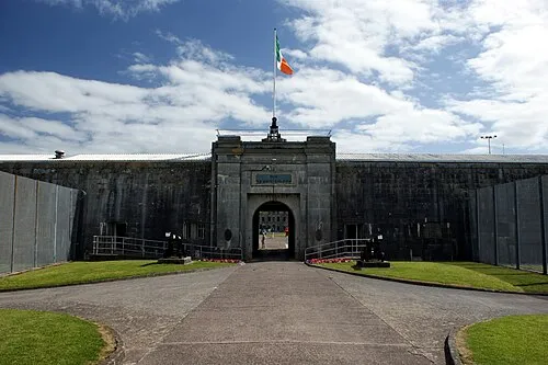 Spike Island Island, County Cork14 km W
-
Ballycotton Lighthouse Landmark, County Cork6.7 km E
-
Stump Hill Mountain, County Cork11 km N
Sources & licences
Data last updated: