- Population
- 90
- 90
- Elevation
- 375 m
- above sea level
- Local time
- UTC+01:00
- Europe/Rome · UTC+01:00
- Airports
- TRS Trieste Airport65 km
- KLU Klagenfurt Airport88 km
About Roveredo
Roveredo is a village. Location: Chiusaforte, Province of Udine. Population: 90. Elevation: 375 m. The best months to visit are May–September. The nearest airport is Trieste Airport (65 km). Nearby sights include Monte Pisimoni and Monte Spiz.
Photos of Roveredo
-
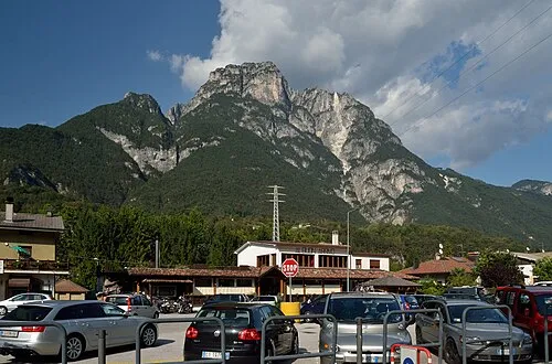
Monte Pisimoni Herzi Pinki · CC BY-SA 4.0

Climate of Roveredo
Best months for sightseeingBest months for sightseeing: May–September.
This month · November
A wet month
Day 10° · Night 3° · Rain 169 mm
- Hottest month
- July (day 26°)
- Coldest month
- January (night -2°)
- Wettest month
- October (187 mm)
- Driest month
- February (74 mm)
Bars: average monthly low and high temperature. Below: precipitation. Monthly averages for 1970–2000 at about 18 km resolution, adjusted for elevation. Highlighted months are mild and relatively dry. Source: WorldClim 2.1 (CC BY 4.0).
Show values as a table
| Month | Jan | Feb | Mar | Apr | May | Jun | Jul | Aug | Sep | Oct | Nov | Dec |
|---|---|---|---|---|---|---|---|---|---|---|---|---|
| Average high (°C) | 6° | 8° | 11° | 15° | 20° | 23° | 26° | 26° | 22° | 16° | 10° | 6° |
| Average low (°C) | -2° | -1° | 2° | 5° | 10° | 13° | 15° | 15° | 12° | 8° | 3° | -1° |
| Precipitation (mm) | 97 | 74 | 110 | 150 | 163 | 174 | 160 | 145 | 165 | 187 | 169 | 121 |
Other places to visit in this season: May June July August September
How to get to Roveredo
The nearest airport is Trieste Airport (TRS), 65 km to the south as the crow flies. The nearest large city is Klagenfurt, 85 km to the east.
Airports
- Trieste Airport (TRS) Ronchi dei Legionari/Trieste 65 kmsouth
- Klagenfurt Airport (KLU) Klagenfurt am Wörthersee 88 kmeast
- Ljubljana Jože Pučnik Airport (LJU) Zgornji Brnik 95 kmeast
Nearby large cities
- Klagenfurt Population: 100.3K 85 kmeast
- Ljubljana Population: 272.2K 104 kmeast
- Rijeka Population: 108K 151 kmsoutheast
- Salzburg Population: 157.2K 157 kmnorth
- Innsbruck Population: 132.5K 171 kmnorthwest
Straight-line distances; road distances are longer. Airport data: OurAirports.
Day trips from Roveredo
Within 100 km: 127 historic and cultural sites, 2,059 natural sites, 452 lakes, rivers and coasts.
0–25 km99 places
- Prestreljenik Mountain 17 kmE
- Egger Alpen See Lake 24 kmNE
- Bodensee Lake 22 kmN
- Creta di Aip Mountain 20 kmN
25–60 km542 places
- Lake Bohinj Lake 49 kmE
- Triglav Mountain 45 kmE
- Rjavina Mountain 49 kmE
- Krn Mountain 35 kmSE
60–100 km1,997 places
- Raša River 81 kmSE
- Lake Bled Lake 65 kmE
- Šmarna gora Mountain 98 kmE
- Porezen Mountain 61 kmSE
Straight-line distances.
Nearby attractions & nature
Everything nearby-
Monte Pisimoni Mountain, Moggio Udinese2.6 km N
-
Monte Spiz Mountain, Resiutta2.9 km SW
-
Monte Posar Mountain, Resia3.9 km E
-
Monte Làvara Mountain, Resiutta5.2 km SW
-
Monte Ciucis Mountain, Moggio Udinese5.5 km W
-
Zuc dal Bor Mountain, Dogna5.9 km N
Other cities and towns in Chiusaforte
-
 Raccolana Village, Chiusaforte5 km E
-
Chiusaforte Village, Chiusaforte4.3 km E
-
Pezzeit Village, Chiusaforte8.1 km E
-
Saletto Village, Chiusaforte9.7 km E
-
Chiout Cali Village, Chiusaforte9.1 km E
-
Frazione Patocco Village, Chiusaforte7.9 km E
Sources & licences
Data last updated: · 2 independent sources