- Population
- 3,786
- 3.8K
- Elevation
- 398 m
- above sea level
- Local time
- UTC+01:00
- Europe/Rome · UTC+01:00
- Places inside
- 7
- listed under Manta
- Airports
- CUF Cuneo International Airport13 km
- TRN Turin Airport66 km
About Manta
Manta is a municipality. Location: Province of Cuneo, Piedmont. Population: 3,786. Elevation: 398 m. The best months to visit are May–September. The nearest airport is Cuneo International Airport (13 km). Nearby sights include Cima Bracco and Castle of the Princes of Acaja.
Photos of Manta
-
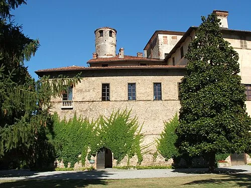
Castello della Manta Immagine creata da Rinina25 & Twice25 Luogo: Saluzzo Data: 5/8/05 · CC BY-SA 2.5

Climate of Manta
Best months for sightseeingBest months for sightseeing: May–September.
This month · November
A cold month
Day 12° · Night 5° · Rain 69 mm
- Hottest month
- July (day 27°)
- Coldest month
- January (night 1°)
- Wettest month
- October (100 mm)
- Driest month
- July (40 mm)
Bars: average monthly low and high temperature. Below: precipitation. Monthly averages for 1970–2000 at about 18 km resolution, adjusted for elevation. Highlighted months are mild and relatively dry. Source: WorldClim 2.1 (CC BY 4.0).
Show values as a table
| Month | Jan | Feb | Mar | Apr | May | Jun | Jul | Aug | Sep | Oct | Nov | Dec |
|---|---|---|---|---|---|---|---|---|---|---|---|---|
| Average high (°C) | 8° | 9° | 13° | 16° | 20° | 24° | 27° | 27° | 22° | 17° | 12° | 9° |
| Average low (°C) | 1° | 2° | 5° | 7° | 12° | 15° | 18° | 18° | 15° | 10° | 5° | 2° |
| Precipitation (mm) | 51 | 50 | 57 | 83 | 93 | 69 | 40 | 61 | 75 | 100 | 69 | 53 |
Other places to visit in this season: May June July August September
How to get to Manta
The nearest airport is Cuneo International Airport (CUF), 13 km to the southeast as the crow flies. For international flights: Turin Airport (TRN) (66 km). The nearest large city is Nice, 103 km to the south.
Airports
- Cuneo International Airport (CUF) Levaldigi (CN) 13 kmsoutheast
- Turin Airport (TRN) Caselle Torinese (TO) 66 kmnorth
- Nice-Côte d'Azur Airport (NCE) Nice, Alpes-Maritimes 109 kmsouth
Nearby large cities
- Nice Population: 342.7K 103 kmsouth
- Grenoble Population: 158.6K 153 kmnorthwest
- Aix-en-Provence Population: 146.8K 203 kmsouthwest
- Geneva Population: 201.7K 205 kmnorthwest
- Toulon Population: 168.7K 208 kmsouthwest
Straight-line distances; road distances are longer. Airport data: OurAirports.
Day trips from Manta
Within 100 km: 60 historic and cultural sites, 882 natural sites, 170 lakes, rivers and coasts.
0–25 km3 places
- Cima Bracco Mountain 14 kmNW
- Castello della Manta Historic site 1 kmSW
- Castle of the Princes of Acaja Historic site 20 kmE
25–60 km305 places
- Lac Premier Lake 53 kmW
- Lac Vert Lake 56 kmW
- Lakes of Vens Lake 55 kmSW
- Lacs de Ténibres Lake 56 kmSW
60–100 km804 places
- Clapes River 96 kmW
- Plage de Buse Beach 95 kmS
- Lac Faravel Lake 85 kmW
- Lac Palluel Lake 86 kmW
Straight-line distances.
Places in Manta
7 placesBar: population relative to the most populous place in this list.
Heritage & sights1
- Castello della Manta · Historic site
Nearby attractions & nature
Everything nearby-
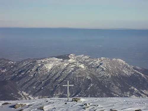 Cima Bracco Mountain, Envie14 km NW
-
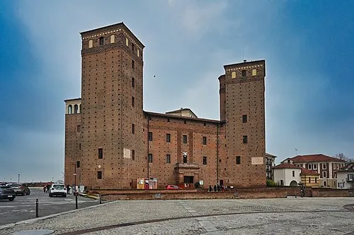 Castle of the Princes of Acaja Historic site, Fossano20 km E
Sources & licences
Data last updated: