- Population
- 9,818
- 9.8K
- Elevation
- 354 m
- above sea level
- Local time
- UTC+01:00
- Europe/Rome · UTC+01:00
- Places inside
- 32
- listed under Barga
- Airports
- PSA Pisa International Airport44 km
- FLR Florence Airport, Peretola65 km
About Barga
Barga is a municipality. Location: Province of Lucca, Tuscany. Population: 9,818. Elevation: 354 m. The best months to visit are May–September. The nearest airport is Pisa International Airport (44 km). Nearby sights include Garfagnana and Monte Giovo.
Climate of Barga
Best months for sightseeingBest months for sightseeing: May–September.
This month · November
A wet month
Day 12° · Night 5° · Rain 197 mm
- Hottest month
- August (day 27°)
- Coldest month
- January (night 1°)
- Wettest month
- November (197 mm)
- Driest month
- July (48 mm)
Bars: average monthly low and high temperature. Below: precipitation. Monthly averages for 1970–2000 at about 18 km resolution, adjusted for elevation. Highlighted months are mild and relatively dry. Source: WorldClim 2.1 (CC BY 4.0).
Show values as a table
| Month | Jan | Feb | Mar | Apr | May | Jun | Jul | Aug | Sep | Oct | Nov | Dec |
|---|---|---|---|---|---|---|---|---|---|---|---|---|
| Average high (°C) | 8° | 9° | 12° | 15° | 20° | 24° | 27° | 27° | 23° | 18° | 12° | 9° |
| Average low (°C) | 1° | 1° | 3° | 6° | 10° | 13° | 16° | 16° | 13° | 9° | 5° | 2° |
| Precipitation (mm) | 138 | 111 | 121 | 141 | 95 | 84 | 48 | 82 | 126 | 174 | 197 | 154 |
Other places to visit in this season: May June July August September
How to get to Barga
The nearest airport is Pisa International Airport (PSA), 44 km to the south as the crow flies. The nearest large city is Nice, 262 km to the west.
Airports
- Pisa International Airport (PSA) Pisa (PI) 44 kmsouth
- Florence Airport, Peretola (FLR) Firenze (FI) 65 kmsoutheast
- Bologna Guglielmo Marconi Airport (BLQ) Bologna 82 kmnortheast
Nearby large cities
- Nice Population: 342.7K 262 kmwest
- Rijeka Population: 108K 343 kmnortheast
- Innsbruck Population: 132.5K 361 kmnorth
- Toulon Population: 168.7K 382 kmwest
- Ljubljana Population: 272.2K 386 kmnortheast
Straight-line distances; road distances are longer. Airport data: OurAirports.
Day trips from Barga
Within 100 km: 61 historic and cultural sites, 188 natural sites, 35 lakes, rivers and coasts.
0–25 km28 places
- Monte Lama Mountain 25 kmNE
- Monte Giovo Mountain 10 kmNE
- Monte Cusna Mountain 25 kmN
- Monte Albano Mountain 12 kmN
25–60 km127 places
- Poggio di Iavello Mountain 50 kmE
- Spiaggia libera per cani Beach 57 kmS
- La Lecciona Beach 32 kmSW
- Spiaggia della Marinella di San Terenzo Beach 47 kmW
60–100 km129 places
- Cormorano Beach 92 kmS
- Cala del Leone Beach 69 kmS
- Spiaggia di Calignaia Beach 68 kmS
- Spiaggia per Cani Beach 64 kmS
Straight-line distances.
Places in Barga
32 places- 1 Barga 3.3K
- 2 Fornaci di Barga 2.4K
- 3 Ponte All'Ania 648
- 4 Filecchio 600
- 5 Castelvecchio Pascoli 590
- 6 Mologno 412
- 7 San Pietro in Campo 214
- 8 Albiano 166
- 9 Giannini 77
- 10 Pian di Gragno 77
- 11 Tiglio Basso 76
- 12 Ponte di Catagnana 65
- 13 Catagnana 59
- 14 Frascone 54
- 15 Sommocolonia 53
- 16 Loppia di Sotto 52
- 17 Stefanetti 47
- 18 Santa Maria 45
- 19 Bugliano 42
- 20 Diversi 42
- 21 A Rigali 37
- 22 La Serra 33
- 23 Orsucci 30
- 24 San Bernardino 27
- 25 Biagi 23
- 26 Tiglio Alto 19
- 27 Conti 17
- 28 Renaio 17
- 29 Bardani 14
- 30 Bebbio 14
- 31 Loppia di Sopra 12
Bar: population relative to the most populous place in this list.
Mountains & nature1
- Cima dell' Omo · Mountain
Nearby attractions & nature
Everything nearby-
Garfagnana Natural site, Tuscany1.5 km NW
-
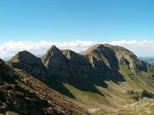 Monte Giovo Mountain, Pievepelago10 km NE
-
Monte Albano Mountain, Tuscany12 km N
-
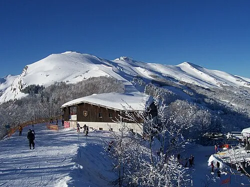 Monte Gomito Mountain, Abetone Cutigliano14 km NE
-
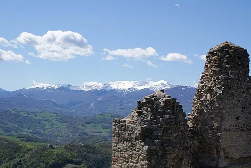 Monte Cusna Mountain, Villa Minozzo25 km N
-
Monte Giovarello Mountain, Castiglione di Garfagnana18 km N
-
Alpicella delle Radici Mountain, Castiglione di Garfagnana16 km N
-
Colle dei Laghi Mountain, Castiglione di Garfagnana17 km N
Sources & licences
Data last updated: