- Population
- 2,548
- 2.5K
- Elevation
- 168 m
- above sea level
- Local time
- UTC+01:00
- Europe/Rome · UTC+01:00
- Airports
- FLR Florence Airport, Peretola43 km
- PSA Pisa International Airport70 km
About Staggia
Staggia is a village. Location: Poggibonsi, Province of Siena. Population: 2,548. Elevation: 168 m. The best months to visit are May–June, September–October. The nearest airport is Florence Airport, Peretola (43 km). Nearby sights include Teatro dei Varii and Church of Santa Maria Assunta.
Photos of Staggia
-
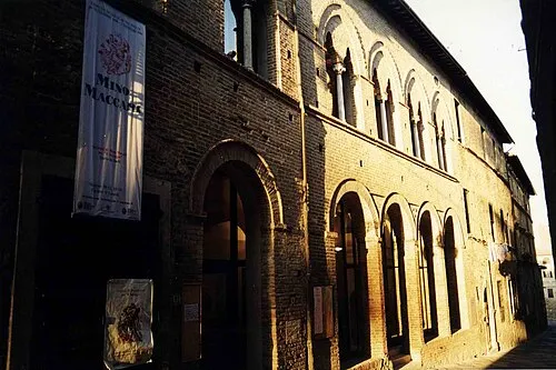
Teatro dei Varii Robyfra1 · Public domain -
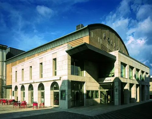
Teatro Politeama Rufilius · CC BY-SA 4.0 -
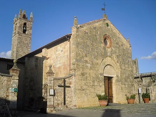
Church of Santa Maria Assunta Alessandro Antonelli · CC BY 3.0


Climate of Staggia
Best months for sightseeingBest months for sightseeing: May–June, September–October.
This month · November
A wet month
Day 15° · Night 8° · Rain 109 mm
- Hottest month
- July (day 30°)
- Coldest month
- January (night 3°)
- Wettest month
- November (109 mm)
- Driest month
- July (34 mm)
Bars: average monthly low and high temperature. Below: precipitation. Monthly averages for 1970–2000 at about 18 km resolution, adjusted for elevation. Highlighted months are mild and relatively dry. Source: WorldClim 2.1 (CC BY 4.0).
Show values as a table
| Month | Jan | Feb | Mar | Apr | May | Jun | Jul | Aug | Sep | Oct | Nov | Dec |
|---|---|---|---|---|---|---|---|---|---|---|---|---|
| Average high (°C) | 10° | 12° | 14° | 18° | 22° | 26° | 30° | 29° | 25° | 20° | 15° | 11° |
| Average low (°C) | 3° | 4° | 6° | 8° | 12° | 15° | 18° | 18° | 15° | 11° | 8° | 4° |
| Precipitation (mm) | 68 | 66 | 68 | 78 | 63 | 53 | 34 | 47 | 75 | 94 | 109 | 85 |
Other places to visit in this season: May June September October
How to get to Staggia
The nearest airport is Florence Airport, Peretola (FLR), 43 km to the north as the crow flies. The nearest large city is Nice, 318 km to the west.
Airports
- Florence Airport, Peretola (FLR) Firenze (FI) 43 kmnorth
- Pisa International Airport (PSA) Pisa (PI) 70 kmnorthwest
- Marina di Campo Airport (EBA) Campo nell'Elba (LI) 106 kmsouthwest
Nearby large cities
- Nice Population: 342.7K 318 kmwest
- Rijeka Population: 108K 335 kmnortheast
- Ljubljana Population: 272.2K 393 kmnortheast
Straight-line distances; road distances are longer. Airport data: OurAirports.
Day trips from Staggia
Within 100 km: 143 historic and cultural sites, 221 natural sites, 46 lakes, rivers and coasts.
0–25 km22 places
- Monte Vasone Mountain 10 kmSW
- Le Masse di Siena Mountain 18 kmSE
- Poggio di Ricavo Mountain 11 kmNE
- Montagnola Mountain 15 kmS
25–60 km63 places
- Cormorano Beach 57 kmW
- Spiaggia Marina di Cecina Beach 58 kmW
- Spiaggia Ippocampo Beach 58 kmW
- Spiaggia Di Domani Beach 60 kmW
60–100 km325 places
- Poggio di Iavello Mountain 61 kmN
- Poggio Mosconcino Mountain 67 kmS
- Parco della Rimembranza Natural site 73 kmS
- Parco di Villa Pizzetti Natural site 74 kmS
Straight-line distances.
Nearby attractions & nature
Everything nearby-
Teatro dei Varii Attraction, Colle di Val d'Elsa5 km W
-
Church of Santa Maria Assunta Attraction, Monteriggioni4.8 km SE
-
Teatro Politeama Attraction, Poggibonsi6 km NW
-
 Torre del Mangia Landmark, Siena17 km SE
-
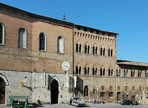 Santa Maria della Scala Museum, Siena17 km SE
-
Monte Vasone Mountain, Casole d'Elsa10 km SW
Other cities and towns in Poggibonsi
-
 Pini Village, Poggibonsi1.9 km NW
-
 Castiglioni Village, Poggibonsi3.9 km W
-
Casastieri Village, Poggibonsi3.2 km N
-
La Gruccia Village, Poggibonsi2.9 km NE
-
Pian dei Pini Village, Poggibonsi1.9 km NW
-
 Talciona Village, Poggibonsi4.7 km N
Sources & licences
Data last updated: