Saviner di Laste
Located in Rocca Pietore, Province of Belluno Coordinates: 46°26′21″ N 11°59′10″ E
- Population
- 136
- 136
- Elevation
- 1,017 m
- above sea level
- Local time
- UTC+01:00
- Europe/Rome · UTC+01:00
- Airports
- BZO Bolzano Airport51 km
- TSF Treviso Airport89 km
About Saviner di Laste
Saviner di Laste is a village. Location: Rocca Pietore, Province of Belluno. Population: 136. Elevation: 1,017 m. The best months to visit are June–September. The nearest airport is Bolzano Airport (51 km). Nearby sights include Monte Pore and Piz Zorlet.
Climate of Saviner di Laste
Best months for sightseeingBest months for sightseeing: June–September.
This month · November
A cold month
Day 8° · Night 2° · Rain 74 mm
- Hottest month
- July (day 22°)
- Coldest month
- February (night -3°)
- Wettest month
- July (133 mm)
- Driest month
- January (40 mm)
Bars: average monthly low and high temperature. Below: precipitation. Monthly averages for 1970–2000 at about 18 km resolution, adjusted for elevation. Highlighted months are mild and relatively dry. Source: WorldClim 2.1 (CC BY 4.0).
Show values as a table
| Month | Jan | Feb | Mar | Apr | May | Jun | Jul | Aug | Sep | Oct | Nov | Dec |
|---|---|---|---|---|---|---|---|---|---|---|---|---|
| Average high (°C) | 4° | 4° | 7° | 10° | 15° | 19° | 22° | 21° | 18° | 14° | 8° | 4° |
| Average low (°C) | -2° | -3° | 0° | 3° | 8° | 11° | 13° | 13° | 10° | 7° | 2° | -1° |
| Precipitation (mm) | 40 | 42 | 52 | 66 | 100 | 122 | 133 | 126 | 97 | 87 | 74 | 42 |
Other places to visit in this season: June July August September
How to get to Saviner di Laste
The nearest airport is Bolzano Airport (BZO), 51 km to the west as the crow flies. For international flights: Treviso Airport (TSF) (89 km). The nearest large city is Innsbruck, 102 km to the northwest.
Airports
- Bolzano Airport (BZO) Bolzano (BZ) 51 kmwest
- Treviso Airport (TSF) Treviso (TV) 89 kmsouth
- Innsbruck Airport (INN) Innsbruck 104 kmnorthwest
Nearby large cities
- Innsbruck Population: 132.5K 102 kmnorthwest
- Salzburg Population: 157.2K 171 kmnortheast
- Klagenfurt Population: 100.3K 179 kmeast
- Munich Population: 1.5M 191 kmnorth
- Ljubljana Population: 272.2K 199 kmeast
Straight-line distances; road distances are longer. Airport data: OurAirports.
Day trips from Saviner di Laste
Within 100 km: 56 historic and cultural sites, 2,902 natural sites, 269 lakes, rivers and coasts.
0–25 km246 places
- Piz Gralba Mountain 17 kmNW
- Piz Miara Mountain 17 kmNW
- Croda Nera Mountain 16 kmW
- Nemesis Mountain 14 kmN
25–60 km777 places
- Sille River 51 kmNE
- Thurntaler Seen Lake 47 kmNE
- Schwarzsee Lake 53 kmNE
- Obersee Lake 53 kmN
60–100 km2,204 places
- Fürlegsee Lake 91 kmNE
- Vorderer Langtalsee Lake 87 kmNE
- Eissee Lake 76 kmNE
- Hacklsee Lake 99 kmNE
Straight-line distances.
Nearby attractions & nature
Everything nearby-
Monte Pore Mountain, Livinallongo del Col di Lana4.7 km NE
-
Piz Zorlet Mountain, Rocca Pietore5.7 km SW
-
Monte Laste Mountain, Livinallongo del Col di Lana6.3 km NW
-
Monte Cernera Mountain, Selva di Cadore6.4 km NE
-
Punta Serauta Mountain, Rocca Pietore7.5 km W
-
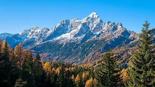 Monte Civetta Mountain, Province of Belluno8.4 km SE
Other cities and towns in Rocca Pietore
-
Sorarù Village, Rocca Pietore1.5 km SW
-
 Le Grazie Village, Rocca Pietore2.6 km SE
-
Val Village, Rocca Pietore2 km NW
-
Boscoverde Village, Rocca Pietore2.4 km SW
-
Sottoguda-Palue Village, Rocca Pietore3.8 km SW
-
Ronch Village, Rocca Pietore1.2 km NW
Sources & licences
Data last updated: · 2 independent sources