- Population
- 3,135
- 3.1K
- Elevation
- 481 m
- above sea level
- Local time
- UTC+01:00
- Europe/Rome · UTC+01:00
- Places inside
- 25
- listed under Sospirolo
- Airports
- TSF Treviso Airport56 km
- BZO Bolzano Airport67 km
About Sospirolo
Sospirolo is a municipality. Location: Province of Belluno, Veneto. Population: 3,135. Elevation: 481 m. The best months to visit are May–September. The nearest airport is Treviso Airport (56 km). Nearby sights include Valle Falcina and Monte Alto.
Climate of Sospirolo
Best months for sightseeingBest months for sightseeing: May–September.
This month · November
A cold month
Day 9° · Night 1° · Rain 81 mm
- Hottest month
- July (day 26°)
- Coldest month
- January (night -3°)
- Wettest month
- June (109 mm)
- Driest month
- February (44 mm)
Bars: average monthly low and high temperature. Below: precipitation. Monthly averages for 1970–2000 at about 18 km resolution, adjusted for elevation. Highlighted months are mild and relatively dry. Source: WorldClim 2.1 (CC BY 4.0).
Show values as a table
| Month | Jan | Feb | Mar | Apr | May | Jun | Jul | Aug | Sep | Oct | Nov | Dec |
|---|---|---|---|---|---|---|---|---|---|---|---|---|
| Average high (°C) | 4° | 7° | 11° | 15° | 20° | 23° | 26° | 26° | 21° | 16° | 9° | 5° |
| Average low (°C) | -3° | -2° | 1° | 5° | 10° | 13° | 16° | 15° | 12° | 7° | 1° | -2° |
| Precipitation (mm) | 50 | 44 | 60 | 78 | 96 | 109 | 94 | 94 | 90 | 101 | 81 | 55 |
Other places to visit in this season: May June July August September
How to get to Sospirolo
The nearest airport is Treviso Airport (TSF), 56 km to the south as the crow flies. The nearest large city is Innsbruck, 135 km to the north.
Airports
- Treviso Airport (TSF) Treviso (TV) 56 kmsouth
- Bolzano Airport (BZO) Bolzano (BZ) 67 kmnorthwest
- Venice Marco Polo Airport (VCE) Venezia (VE) 74 kmsouth
Nearby large cities
- Innsbruck Population: 132.5K 135 kmnorth
- Klagenfurt Population: 100.3K 180 kmeast
- Ljubljana Population: 272.2K 188 kmeast
- Salzburg Population: 157.2K 199 kmnorth
- Rijeka Population: 108K 206 kmsoutheast
Straight-line distances; road distances are longer. Airport data: OurAirports.
Day trips from Sospirolo
Within 100 km: 63 historic and cultural sites, 1,806 natural sites, 89 lakes, rivers and coasts.
0–25 km116 places
- Monte Sambuga Mountain 16 kmSE
- Monte Cor Mountain 18 kmSE
- Monte Cimone Mountain 18 kmSE
- Monte Croce Mountain 13 kmSE
25–60 km550 places
- Piz Gralba Mountain 47 kmNW
- Piz Miara Mountain 48 kmNW
- Croda Nera Mountain 40 kmNW
- Mislkopf Mountain 43 kmW
60–100 km1,292 places
- Burano Island 78 kmS
- Sacca Fisola Island 81 kmS
- San Clemente Island 84 kmS
- Dosso Rotondo Mountain 93 kmSW
Straight-line distances.
Places in Sospirolo
25 placesSospirolo
Population: 700

Mis
Population: 643

Oregne
Population: 257

San Zenon
Population: 170

Torbe
Population: 132
Fant
Population: 126
- 7 Belvedere 111
- 8 Gron 96
- 9 Rosolin 48
- 10 Rorei 42
- 11 Col Molin 41
- 12 Mezzacasa 36
- 13 Campaz 34
- 14 San Gottardo 27
- 15 Rosse Alte 24
- 16 Sopra Sospirolo 19
- 17 Ai Pissa 18
- 18 Case Barp 17
- 19 Certosa di Vedana 15
- 20 Case al Lago 14
- 21 Casera 13
- 22 Piai 10
- 23 Masiere 7
Bar: population relative to the most populous place in this list.
Mountains & nature2
- Cima Peralora · Mountain
- Monte Gena · Mountain
Nearby attractions & nature
Everything nearby-
Valle Falcina Natural site, Veneto2.8 km NW
-
Monte Alto Mountain, Sedico6.6 km N
-
Monte Peron Mountain, Belluno7.3 km NE
-
Monte Brandol Mountain, Cesiomaggiore7.8 km NW
-
Monte Stornade Mountain, Sedico8.7 km N
-
Piz Di Mezzodi Mountain, Rivamonte Agordino9.1 km N
-
Monte Pala Mountain, Sedico8.9 km NE
-
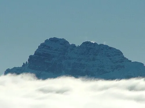 Sass de Mura Mountain, Cesiomaggiore12 km W
Sources & licences
Data last updated: