Vallada Agordina
Located in Province of Belluno, Veneto Coordinates: 46°21′52″ N 11°56′02″ E
- Population
- 485
- 485
- Elevation
- 965 m
- above sea level
- Local time
- UTC+01:00
- Europe/Rome · UTC+01:00
- Places inside
- 5
- listed under Vallada Agordina
- Airports
- BZO Bolzano Airport48 km
- TSF Treviso Airport82 km
About Vallada Agordina
Vallada Agordina is a municipality. Location: Province of Belluno, Veneto. Population: 485. Elevation: 965 m. The best months to visit are June–September. The nearest airport is Bolzano Airport (48 km). Nearby sights include Piz Croce and Cima Di Sanson.
Climate of Vallada Agordina
Best months for sightseeingBest months for sightseeing: June–September.
This month · November
A cold month
Day 8° · Night 2° · Rain 74 mm
- Hottest month
- July (day 22°)
- Coldest month
- February (night -2°)
- Wettest month
- July (133 mm)
- Driest month
- January (40 mm)
Bars: average monthly low and high temperature. Below: precipitation. Monthly averages for 1970–2000 at about 18 km resolution, adjusted for elevation. Highlighted months are mild and relatively dry. Source: WorldClim 2.1 (CC BY 4.0).
Show values as a table
| Month | Jan | Feb | Mar | Apr | May | Jun | Jul | Aug | Sep | Oct | Nov | Dec |
|---|---|---|---|---|---|---|---|---|---|---|---|---|
| Average high (°C) | 4° | 5° | 7° | 11° | 16° | 20° | 22° | 22° | 18° | 14° | 8° | 5° |
| Average low (°C) | -2° | -2° | 0° | 3° | 8° | 11° | 13° | 13° | 10° | 7° | 2° | -1° |
| Precipitation (mm) | 40 | 42 | 52 | 66 | 100 | 122 | 133 | 126 | 97 | 87 | 74 | 42 |
Other places to visit in this season: June July August September
How to get to Vallada Agordina
The nearest airport is Bolzano Airport (BZO), 48 km to the west as the crow flies. For international flights: Treviso Airport (TSF) (82 km). The nearest large city is Innsbruck, 108 km to the north.
Airports
- Bolzano Airport (BZO) Bolzano (BZ) 48 kmwest
- Treviso Airport (TSF) Treviso (TV) 82 kmsouth
- Venice Marco Polo Airport (VCE) Venezia (VE) 101 kmsouth
Nearby large cities
- Innsbruck Population: 132.5K 108 kmnorth
- Salzburg Population: 157.2K 180 kmnortheast
- Klagenfurt Population: 100.3K 184 kmeast
- Munich Population: 1.5M 199 kmnorth
- Ljubljana Population: 272.2K 201 kmeast
Straight-line distances; road distances are longer. Airport data: OurAirports.
Day trips from Vallada Agordina
Within 100 km: 44 historic and cultural sites, 2,634 natural sites, 204 lakes, rivers and coasts.
0–25 km241 places
- Piz Gralba Mountain 21 kmNW
- Piz Miara Mountain 21 kmNW
- Croda Nera Mountain 14 kmNW
- Nemesis Mountain 23 kmNE
25–60 km637 places
- Thurntaler Seen Lake 56 kmNE
- Demut Mountain 53 kmNE
- Cima Vallona Mountain 57 kmNE
- Monte Cavallino Mountain 57 kmNE
60–100 km2,004 places
- Spadalone Mountain 97 kmW
- Dosso Rotondo Mountain 98 kmSW
- Sille River 60 kmNE
- Vorderer Langtalsee Lake 96 kmNE
Straight-line distances.
Places in Vallada Agordina
5 placesBar: population relative to the most populous place in this list.
Mountains & nature1
- Monte Celenton · Mountain
Nearby attractions & nature
Everything nearby-
Piz Croce Mountain, Trentino-Alto Adige2.2 km NE
-
Cima Di Sanson Mountain, Canale d'Agordo3.4 km S
-
Piz Zorlet Mountain, Rocca Pietore3.8 km N
-
Monte Pettenassa Mountain, Trentino-Alto Adige4.1 km SW
-
Monte Alto Mountain, Trentino-Alto Adige5.4 km NW
-
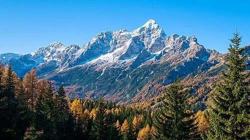 Monte Civetta Mountain, Province of Belluno9.3 km E
-
Monte Tamer Mountain, Trentino-Alto Adige5.6 km SW
-
Cimon della Stia Mountain, Trentino-Alto Adige6.5 km SW
Sources & licences
Data last updated: