Ikata
Local name: 伊方町
Located in Nishiuwa-gun, Ehime Coordinates: 33°29′24″ N 132°21′17″ E
- Population
- 12,500
- 12.5K
- Elevation
- 4 m
- above sea level
- Local time
- UTC+09:00
- Asia/Tokyo · UTC+09:00
- Places inside
- 2
- listed under Ikata
- Airports
- MYJ Matsuyama Airport49 km
- OIT Oita Airport57 km
About Ikata
Ikata is a municipality. Location: Nishiuwa-gun, Ehime. Population: 12,500. Elevation: 4 m.
Ikata (伊方町, Ikata-chō) is a small peninsula town located in Nishiuwa District, Ehime Prefecture, Japan. As of 31 August 2022, the town had an estimated population of 8,497 in 15638 households and a population density of 90 persons per km2.
Source: Wikipedia · CC BY-SA 4.0
Population of Ikata over time
| 2010 | 10,882 | |
|---|---|---|
| 2015 | 9,626 | |
| 2021 | 8,253 |
Censuses and official estimates; source: Wikidata.
Climate of Ikata
Best months for sightseeingBest months for sightseeing: May–June, October–November.
This month · November
A good month to visit
Day 18° · Night 9° · Rain 80 mm
- Hottest month
- August (day 31°)
- Coldest month
- January (night 2°)
- Wettest month
- June (248 mm)
- Driest month
- January (62 mm)
Bars: average monthly low and high temperature. Below: precipitation. Monthly averages for 1970–2000 at about 18 km resolution, adjusted for elevation. Highlighted months are mild and relatively dry. Source: WorldClim 2.1 (CC BY 4.0).
Show values as a table
| Month | Jan | Feb | Mar | Apr | May | Jun | Jul | Aug | Sep | Oct | Nov | Dec |
|---|---|---|---|---|---|---|---|---|---|---|---|---|
| Average high (°C) | 10° | 11° | 14° | 19° | 23° | 26° | 30° | 31° | 28° | 23° | 18° | 13° |
| Average low (°C) | 2° | 3° | 5° | 11° | 15° | 19° | 23° | 24° | 21° | 15° | 9° | 4° |
| Precipitation (mm) | 62 | 82 | 121 | 171 | 177 | 248 | 245 | 167 | 223 | 142 | 80 | 69 |
Other places to visit in this season: May June October November
How to get to Ikata
The nearest airport is Matsuyama Airport (MYJ), 49 km to the northeast as the crow flies. The nearest large city is Matsuyama, 54 km to the northeast.
Airports
- Matsuyama Airport (MYJ) Matsuyama 49 kmnortheast
- Oita Airport (OIT) Oita 57 kmwest
- Iwakuni Kintaikyo Airport (IWK) Iwakuni 73 kmnorth
Nearby large cities
- Matsuyama Population: 511.2K 54 kmnortheast
- Ōita Population: 477.7K 76 kmwest
- Iwakuni Population: 129.1K 76 kmnorth
- Tokuyama Population: 101.1K 80 kmnorthwest
- Shūnan Population: 149.6K 82 kmnorthwest
Straight-line distances; road distances are longer. Airport data: OurAirports.
Places in Ikata
2 placesNearby attractions & nature
Everything nearby-
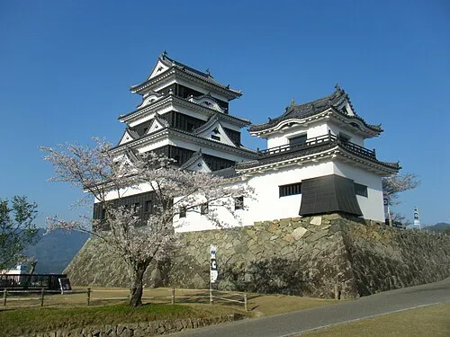 Ozu Castle Historic site, Ōzu17 km E
-
Sadamisaki Peninsula Natural site, Japan16 km SW
Sources & licences
Data last updated: · 2 independent sources