- Population
- 20,808
- 20.8K
- Elevation
- 397 m
- above sea level
- Local time
- UTC+09:00
- Asia/Tokyo · UTC+09:00
- Airports
- FKS Fukushima Airport25 km
- IBR Ibaraki Airport110 km
About Kumakura
Kumakura is a town. Location: Nishigō Mura, Nishishirakawa-gun. Population: 20,808. Elevation: 397 m. The best months to visit are May–July, September. The nearest airport is Fukushima Airport (25 km). Nearby sights include Chausu Dake and Mount Nasu.
Climate of Kumakura
Best months for sightseeingBest months for sightseeing: May–July, September.
This month · November
Outside the best season
Day 12° · Night 3° · Rain 65 mm
Better nearby cities in November
- Isehara · 210 km south18°
- Kofu · 219 km southwest17°
- Odawara · 230 km southwest19°
- Hottest month
- August (day 27°)
- Coldest month
- January (night -4°)
- Wettest month
- August (189 mm)
- Driest month
- January (33 mm)
Bars: average monthly low and high temperature. Below: precipitation. Monthly averages for 1970–2000 at about 18 km resolution, adjusted for elevation. Highlighted months are mild and relatively dry. Source: WorldClim 2.1 (CC BY 4.0).
Show values as a table
| Month | Jan | Feb | Mar | Apr | May | Jun | Jul | Aug | Sep | Oct | Nov | Dec |
|---|---|---|---|---|---|---|---|---|---|---|---|---|
| Average high (°C) | 5° | 5° | 8° | 15° | 19° | 22° | 26° | 27° | 23° | 18° | 12° | 7° |
| Average low (°C) | -4° | -4° | -2° | 4° | 9° | 14° | 18° | 19° | 15° | 9° | 3° | -2° |
| Precipitation (mm) | 33 | 46 | 72 | 100 | 114 | 165 | 159 | 189 | 188 | 125 | 65 | 38 |
Other places to visit in this season: May June July September
How to get to Kumakura
The nearest airport is Fukushima Airport (FKS), 25 km to the east as the crow flies. For international flights: Ibaraki Airport (IBR) (110 km). The nearest large city is Kōriyama, 33 km to the northeast.
Airports
- Fukushima Airport (FKS) Sukagawa 25 kmeast
- Ibaraki Airport (IBR) Omitama 110 kmsouth
- Sendai Airport (SDJ) Natori 128 kmnortheast
Nearby large cities
- Kōriyama Population: 327.7K 33 kmnortheast
- Aizu-Wakamatsu Population: 118.2K 42 kmnorthwest
- Iwaki Population: 357.3K 65 kmeast
- Utsunomiya Population: 518.8K 70 kmsouth
- Fukushima Population: 294.2K 71 kmnorth
Straight-line distances; road distances are longer. Airport data: OurAirports.
Day trips from Kumakura
Within 100 km: 1 historic or cultural site, 21 natural sites, 6 lakes, rivers and coasts.
0–25 km2 places
- Mount Nasu Mountain 20 kmW
- Chausu Dake Mountain 19 kmW
25–60 km6 places
- Mount Adatara Mountain 53 kmN
- Lake Inawashiro Lake 37 kmN
- Tsuruga Castle Historic site 43 kmNW
- Nekomaga Dake Mountain 52 kmN
60–100 km20 places
- Mount Kaba Mountain 95 kmS
- Echigo Sanmyaku Mountain 81 kmN
- Kuji-gawa River 84 kmSE
- Lake Chūzenji Lake 78 kmSW
Straight-line distances.
Nearby attractions & nature
Everything nearby-
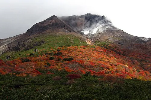 Chausu Dake Mountain, Nasu Machi19 km W
-
 Mount Nasu Mountain, Tochigi20 km W
Sources & licences
Data last updated: