- Population
- 7,859
- 7.9K
- Elevation
- 189 m
- above sea level
- Local time
- UTC+09:00
- Asia/Tokyo · UTC+09:00
- Places inside
- 1
- listed under Sekigahara Chō
- Airports
- NKM Nagoya Airport / JASDF Komaki Air Base45 km
- NGO Chubu Centrair International Airport63 km
About Sekigahara Chō
Sekigahara Chō is a municipality. Location: Fuwa-gun, Gifu. Population: 7,859. Elevation: 189 m.
Sekigahara (関ケ原町, Sekigahara-chō) is a town located in Fuwa District, Gifu Prefecture, Japan. As of 1 December 2018, the town had an estimated population of 7,109 and a population density of 140 persons per km2, in 2,725 households. The total area of the town was 49.28 square kilometres (19.03 sq mi). The town is most famous for the Battle of Sekigahara which ended the Sengoku Period and created the Tokugawa Shogunate.
Source: Wikipedia · CC BY-SA 4.0
Travel notes for Sekigahara Chō
From Wikivoyage
Sekigahara (関ヶ原町 Sekigahara-chō) is a rural town at the western edge of Gifu Prefecture in the Chubu region of Japan. It is most famous for the October 1600 Battle of Sekigahara, but its picturesque location nestled in a small valley between mountains, combined with its complete lack of large tour buses, makes it a nice day trip from the larger nearby cities of Kyoto, Nagoya, and Kanazawa. The small size of the town and the well-marked paths between historic sites make Sekigahara even more appealing, as a visitor can traverse the entire battlefield in about a day.
You will need a solid understanding of Japanese, or a good translator, if you wish to interact with the town on a deeper level, but English-language material is available in the museums and on historical signs by the sites.
Understand+
Sekigahara was the site of the epic Battle of Sekigahara (関ヶ原合戦 Sekigahara gassen) between Tokugawa Ieyasu and Ishida Mitsunari, representing Toyotomi Hideyoshi's son and designated successor Toyotomi Hideyori. The Cliff's Notes version: Ishida's Western Alliance had 120,000 troops against the 75,000 of Tokugawa's Eastern Alliance, but Tokugawa cleverly exploited various grievances in Ishida's ranks to convince six daimyo (regional warlords) to defect along with some 23,000 troops, tipping the scales of the battle. A mere two hours after the battle began on the morning of October 21, 1600, the Western Alliance was in tatters and a total of some 40,000 lay dead. Ishida escaped but was captured and executed on November 6th.
Tokugawa's victory on heralded the beginning of the Edo Period, and with it the rise of the Shogunate. The destruction of most of the forces of the Western Alliance allowed Tokugawa to rapidly consolidate control of Japan within the following four months, as previously-Western or neutral daimyos either joined with Tokugawa or were crushed by him. Consequently, the town is filled with ruins, memorials and shrines to the dead. (There is a river called Kurochigawa (黒血川, "Black Blood River"), where the Tokugawa armies washed the cut-off heads of those fallen in battle, but the name had originated in the Jinshin War in the 7th century under similar circumstances.)
Today's Sekigahara is a rural town with a population just over 7,000. Due to its historical significance, Sekigahara is a sister city with both Waterloo in Belgium and Gettysburg in the US. It can also be inundated with Japanese tourists (particularly schoolchildren) during certain parts of the Japanese school year because of its importance in Japanese history.
Tourist information:
Get in+
By train:
The JR Tokaido Shinkansen line passes through Sekigahara on its way from Osaka to Nagoya, but it does not stop in the town. If coming from Kyoto (as most Western tourists tend to do), take the Shinkansen to Maibara, and then change to the JR Tokaido Line. The Shinkansen leg takes 19 minutes and the Tokaido leg takes 21 minutes, so the trip can be done in about an hour or even quicker if you time it right with trains. Make sure to take the Hikari or Kodama Shinkansen, as that will stop at every station (the other Shinkansen do not stop at Maibara). Maibara is the first stop going east from Kyoto on the Hikari or Kodama Shinkansen. If traveling on a Seishun 18 ticket or other pass that does not permit use of the Shinkansen, take the Special Rapid (新快速) to Maibara and change to the JR Central portion of the Tokaido Line. When using the Special Rapid train, the JR West leg takes 1 hour 7 minutes.
If coming from Tokyo, one of two hourly Hikari services from Tokyo stops at Maibara, and you can transfer to the Tokaido Line local for the run to Sekigahara (total time 3 hours, ¥12,070, no charge with JR Pass).
1 Sekigahara Station (関ケ原駅). is a small unstaffed rural station, with two platforms (four trains) and one entrance/exit on the south side of the tracks. Within the building there are a few vending machines and restrooms. Other than that, there's nothing else in the station (no restaurants, shops, etc.). (updated May 2024)
By car:
Source: Wikivoyage · CC BY-SA 4.0 · abridged
Places bordering Sekigahara Chō
- Ōgaki
- Tarui
- Ibigawa Chō
- Maibara
Twin towns and sister cities of Sekigahara Chō
- Okazaki· Japan
Source: Wikidata. Only places with a page on this site are shown.
Population of Sekigahara Chō over time
| 2010 | 8,096 | |
|---|---|---|
| 2015 | 7,419 | |
| 2020 | 6,701 |
Censuses and official estimates; source: Wikidata.
Climate of Sekigahara Chō
Best months for sightseeingBest months for sightseeing: May–June, September–October.
This month · November
A wet month
Day 15° · Night 6° · Rain 105 mm
Better nearby cities in November
- Kofu · 195 km east17°
- Fujinomiya · 198 km east18°
- Fuji · 204 km east20°
- Hottest month
- August (day 30°)
- Coldest month
- February (night -1°)
- Wettest month
- July (268 mm)
- Driest month
- December (100 mm)
Bars: average monthly low and high temperature. Below: precipitation. Monthly averages for 1970–2000 at about 18 km resolution, adjusted for elevation. Highlighted months are mild and relatively dry. Source: WorldClim 2.1 (CC BY 4.0).
Show values as a table
| Month | Jan | Feb | Mar | Apr | May | Jun | Jul | Aug | Sep | Oct | Nov | Dec |
|---|---|---|---|---|---|---|---|---|---|---|---|---|
| Average high (°C) | 6° | 7° | 10° | 17° | 21° | 25° | 29° | 30° | 26° | 20° | 15° | 9° |
| Average low (°C) | 0° | -1° | 2° | 7° | 12° | 17° | 22° | 22° | 19° | 12° | 6° | 2° |
| Precipitation (mm) | 113 | 108 | 139 | 176 | 176 | 262 | 268 | 188 | 250 | 142 | 105 | 100 |
Other places to visit in this season: May June September October
How to get to Sekigahara Chō
The nearest airport is Nagoya Airport / JASDF Komaki Air Base (NKM), 45 km to the east as the crow flies. For international flights: Chubu Centrair International Airport (NGO) (63 km). The nearest large city is Ōgaki, 16 km to the east.
Airports
- Nagoya Airport / JASDF Komaki Air Base (NKM) Nagoya 45 kmeast
- Chubu Centrair International Airport (NGO) Tokoname 63 kmsoutheast
- Osaka Itami International Airport (ITM) Osaka 111 kmsouthwest
Nearby large cities
- Ōgaki Population: 161.5K 16 kmeast
- Nagahama Population: 113.6K 17 kmwest
- Hikone Population: 113.6K 21 kmsouthwest
- Gifu Population: 402.6K 30 kmeast
- Inazawa Population: 134.8K 33 kmeast
Straight-line distances; road distances are longer. Airport data: OurAirports.
Day trips from Sekigahara Chō
Within 100 km: 29 historic and cultural sites, 23 natural sites, 34 lakes, rivers and coasts.
0–25 km4 places
- Neo River River 19 kmE
- Mount Ryōzen Mountain 10 kmSW
- Mount Ibuki Mountain 9 kmNW
- Hikone castle Historic site 19 kmSW
25–60 km24 places
- Hida River River 56 kmE
- Nikkō River River 46 kmSE
- Hori River River 49 kmSE
- Mount Komaki Mountain 43 kmE
60–100 km58 places
- Tōshi-jima Island 100 kmSE
- Himakajima Island 88 kmSE
- Kumozu River River 79 kmS
- Kuzuryu River River 99 kmN
Straight-line distances.
Places in Sekigahara Chō
1 placeBar: population relative to the most populous place in this list.
Nearby attractions & nature
Everything nearby-
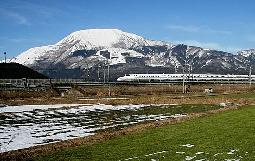 Mount Ibuki Mountain, Maibara-shi8.6 km NW
-
Mount Ryōzen Mountain, Taga Chō9.5 km SW
-
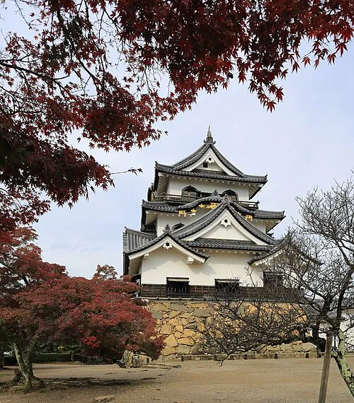 Hikone castle Historic site, Hikone19 km SW
-
Neo River River, Gifu19 km E
Sources & licences
Data last updated: · 2 independent sources