Matsumae Chō
Local name: 松前町
Located in Matsumae-gun, Hokkaido Coordinates: 41°30′54″ N 140°03′54″ E
- Population
- 8,501
- 8.5K
- Elevation
- 197 m
- above sea level
- Local time
- UTC+09:00
- Asia/Tokyo · UTC+09:00
- Places inside
- 4
- listed under Matsumae Chō
- Airports
- HKD Hakodate Airport69 km
- OIR Okushiri Airport81 km
About Matsumae Chō
Matsumae Chō is a municipality. Location: Matsumae-gun, Hokkaido. Population: 8,501. Elevation: 197 m.
Matsumae (松前町, Matsumae-chō) is a town located in Oshima Subprefecture, Hokkaido, Japan. The former home of the Matsumae Han, it has an Edo period castle, Matsumae Castle, the only one in Hokkaido, and Ryūun-in. The total area of the town is 293.11 square kilometres (113.17 mi2).
Source: Wikipedia · CC BY-SA 4.0
Photos of Matsumae Chō
-
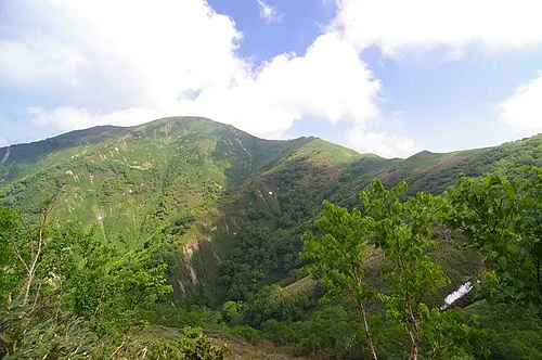
Daisengen-dake DrTerraKhan · CC BY-SA 3.0 -

Shirakami Misaki 利用者:としぴい · CC BY-SA 3.0


Travel notes for Matsumae Chō
From Wikivoyage
Matsumae (松前) is a small town in Hokkaido. It has the only traditional-style castle in
Hokkaido.
Understand+
Tourist information site:
The local tourist association has a Japanese-only guide site with integrated Google Translate.
Get in+
From Hakodate, take the train to Kikonai. (It takes anywhere from 40-65 minutes depending on the train you take.) A bus leaves that station bound for Matsumae. (It takes about 90 minutes to get to Matsumae Castle and the fare is ¥1210.)
Matsumae Castle (Matsumae-jo) is not the last stop so be alert when you enter the town. As you drive along the coast, you can see the castle to your right. It will be behind a big building that is easy to identify as a hospital. When you can see it, ring the bell to get off. Then walk for about 10 minutes up the hill towards it.
Source: Wikivoyage · CC BY-SA 4.0 · abridged
Places bordering Matsumae Chō
- Fukushima Chō
- Kaminokuni
Twin towns and sister cities of Matsumae Chō
- Date-shi· Japan
- Ōmihachiman· Japan
- Masaki· Japan
Source: Wikidata. Only places with a page on this site are shown.
Population of Matsumae Chō over time
| 2010 | 8,748 | |
|---|---|---|
| 2014 | 8,331 | |
| 2015 | 7,337 | |
| 2020 | 6,754 |
Censuses and official estimates; source: Wikidata.
Climate of Matsumae Chō
Best months for sightseeingBest months for sightseeing: June–September.
This month · November
A wet month
Day 8° · Night 2° · Rain 112 mm
- Hottest month
- August (day 25°)
- Coldest month
- January (night -7°)
- Wettest month
- September (170 mm)
- Driest month
- February (80 mm)
Bars: average monthly low and high temperature. Below: precipitation. Monthly averages for 1970–2000 at about 18 km resolution, adjusted for elevation. Highlighted months are mild and relatively dry. Source: WorldClim 2.1 (CC BY 4.0).
Show values as a table
| Month | Jan | Feb | Mar | Apr | May | Jun | Jul | Aug | Sep | Oct | Nov | Dec |
|---|---|---|---|---|---|---|---|---|---|---|---|---|
| Average high (°C) | -2° | -1° | 3° | 10° | 15° | 19° | 23° | 25° | 21° | 16° | 8° | 1° |
| Average low (°C) | -7° | -6° | -2° | 3° | 8° | 13° | 17° | 19° | 15° | 9° | 2° | -4° |
| Precipitation (mm) | 99 | 80 | 84 | 92 | 97 | 100 | 151 | 156 | 170 | 121 | 112 | 102 |
Other places to visit in this season: June July August September
How to get to Matsumae Chō
The nearest airport is Hakodate Airport (HKD), 69 km to the northeast as the crow flies. The nearest large city is Hakodate, 63 km to the northeast.
Airports
- Hakodate Airport (HKD) Hakodate 69 kmnortheast
- Okushiri Airport (OIR) Okushiri Island 81 kmnorthwest
- Aomori Airport (AOJ) Aomori 101 kmsoutheast
Nearby large cities
- Hakodate Population: 275.7K 63 kmnortheast
- Aomori Population: 298.4K 96 kmsoutheast
- Hirosaki Population: 168.7K 108 kmsouth
- Hachinohe Population: 239K 165 kmsoutheast
- Tomakomai Population: 174.8K 178 kmnortheast
Straight-line distances; road distances are longer. Airport data: OurAirports.
Day trips from Matsumae Chō
Within 100 km: 4 historic and cultural sites, 18 natural sites, 14 lakes, rivers and coasts.
0–25 km4 places
- Mount Nagayama Mountain 16 kmNE
- Daisengen-dake Mountain 11 kmNE
- Shirakami Misaki Natural site 17 kmSE
- Fukuyama Jō Historic site 10 kmS
25–60 km6 places
- Kamome Island Island 39 kmN
- Mount Hakodate Mountain 60 kmNE
- Amanogawa River River 32 kmN
- Lake Jūsan Lake 59 kmSE
60–100 km26 places
- Okushiri Island Island 87 kmNW
- Tokoro River River 86 kmNE
- Shiryōkaku Historic site 68 kmNE
- Hakodate Arena Landmark 67 kmNE
Straight-line distances.
Places in Matsumae Chō
4 placesMatsumae
Population: 6.3K
-
-
Sources & licences
Data last updated: · 2 independent sources