- Elevation
- 212 m
- above sea level
- Local time
- UTC+09:00
- Asia/Tokyo · UTC+09:00
- Airports
- TAK Takamatsu Airport8 km
- TKS Tokushima Awaodori Airport / JMSDF Tokushima Air Base49 km
About Shionoe
Shionoe is a village. Location: Takamatsu Shi, Kagawa. Elevation: 212 m.
Shionoe (塩江町, Shionoe-chō) was a Japanese town located in Kagawa District, Kagawa. As of 2003, the town had an estimated population of 3,583 and a density of 44.73 persons per km2. The total area was 80.10 km2. On September 26, 2005, Shionoe was merged into the expanded city of Takamatsu and created to exist as an independent municipality.
Source: Wikipedia · CC BY-SA 4.0
At a glance
- Built
- 1956
- Area
- 80.1 km²
Source: Wikidata
Twin towns and sister cities of Shionoe
- Shimanto Shi· Japan
Source: Wikidata. Only places with a page on this site are shown.
Climate of Shionoe
Best months for sightseeingBest months for sightseeing: May–June, September–October.
This month · November
Outside the best season
Day 15° · Night 7° · Rain 81 mm
Better nearby cities in November
- Kochi · 86 km southwest18°
- Ōita · 252 km southwest18°
- Beppu · 259 km west17°
- Hottest month
- August (day 30°)
- Coldest month
- January (night 0°)
- Wettest month
- September (250 mm)
- Driest month
- December (37 mm)
Bars: average monthly low and high temperature. Below: precipitation. Monthly averages for 1970–2000 at about 18 km resolution, adjusted for elevation. Highlighted months are mild and relatively dry. Source: WorldClim 2.1 (CC BY 4.0).
Show values as a table
| Month | Jan | Feb | Mar | Apr | May | Jun | Jul | Aug | Sep | Oct | Nov | Dec |
|---|---|---|---|---|---|---|---|---|---|---|---|---|
| Average high (°C) | 7° | 8° | 12° | 17° | 22° | 25° | 29° | 30° | 26° | 21° | 15° | 10° |
| Average low (°C) | 0° | 0° | 3° | 8° | 13° | 18° | 22° | 23° | 19° | 13° | 7° | 2° |
| Precipitation (mm) | 44 | 59 | 94 | 151 | 161 | 249 | 207 | 136 | 250 | 127 | 81 | 37 |
Other places to visit in this season: May June September October
How to get to Shionoe
The nearest airport is Takamatsu Airport (TAK), 8 km to the northwest as the crow flies. The nearest large city is Takamatsu, 18 km to the north.
Airports
- Takamatsu Airport (TAK) Takamatsu 8 kmnorthwest
- Tokushima Awaodori Airport / JMSDF Tokushima Air Base (TKS) Tokushima 49 kmeast
- Okayama Momotaro Airport (OKJ) Okayama 68 kmnorth
Nearby large cities
- Takamatsu Population: 419K 18 kmnorth
- Marugame Population: 109.5K 30 kmnorthwest
- Tokushima Population: 267.3K 46 kmeast
- Kurashiki Population: 483.6K 54 kmnorthwest
- Fukuyama Population: 468.8K 74 kmnorthwest
Straight-line distances; road distances are longer. Airport data: OurAirports.
Day trips from Shionoe
Within 100 km: 13 historic and cultural sites, 8 natural sites, 32 lakes, rivers and coasts.
0–25 km2 places
- Yashima Natural site 22 kmN
- Takamatsu castle Historic site 20 kmN
25–60 km23 places
- Nao Shima Island 33 kmN
- Shiwaku Islands Island 41 kmNW
- Te Shima Island 34 kmN
- Manabe Island Island 50 kmNW
60–100 km28 places
- Shikoku Island 71 kmSW
- Awaji Island Island 73 kmE
- Ikuchi Jima Island 91 kmW
- Ōmi Shima Island 99 kmW
Straight-line distances.
Nearby attractions & nature
Everything nearby-
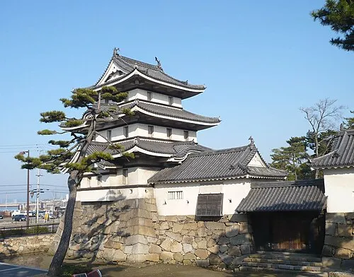 Takamatsu castle Historic site, Takamatsu Shi20 km N
-
Yashima Natural site, Kagawa22 km N
Sources & licences
Data last updated: · 2 independent sources