- Population
- 8,686
- 8.7K
- Elevation
- 200 m
- above sea level
- Local time
- UTC+09:00
- Asia/Tokyo · UTC+09:00
- Airports
- KOJ Kagoshima Airport66 km
- TNE New Tanegashima Airport69 km
About Kinkō Chō
Kinkō Chō is a municipality. Location: Kimotsuki Gun, Kagoshima. Population: 8,686. Elevation: 200 m.
Kinkō (錦江町, Kinkō-chō) is a town located in Kimotsuki District, Kagoshima Prefecture, Japan. As of 31 March 2024, the town had an estimated population of 6,276 in 3490 households, and a population density of 38 persons per km2. The total area of the town is 163.19 km2 (63.01 sq mi).
Source: Wikipedia · CC BY-SA 4.0
Places bordering Kinkō Chō
- Kanoya
- Kimotsuki Chō
- Minamiōsumi Chō
Population of Kinkō Chō over time
| 2010 | 8,987 | |
|---|---|---|
| 2015 | 7,923 | |
| 2021 | 6,808 |
Censuses and official estimates; source: Wikidata.
Climate of Kinkō Chō
Best months for sightseeingBest months for sightseeing: May–June, October.
This month · November
A wet month
Day 18° · Night 10° · Rain 118 mm
Better nearby cities in November
- Kanoya · 19 km north19°
- Kagoshima · 49 km northwest19°
- Kirishima · 59 km north19°
- Hottest month
- August (day 29°)
- Coldest month
- January (night 2°)
- Wettest month
- June (467 mm)
- Driest month
- December (90 mm)
Bars: average monthly low and high temperature. Below: precipitation. Monthly averages for 1970–2000 at about 18 km resolution, adjusted for elevation. Highlighted months are mild and relatively dry. Source: WorldClim 2.1 (CC BY 4.0).
Show values as a table
| Month | Jan | Feb | Mar | Apr | May | Jun | Jul | Aug | Sep | Oct | Nov | Dec |
|---|---|---|---|---|---|---|---|---|---|---|---|---|
| Average high (°C) | 11° | 12° | 15° | 19° | 23° | 25° | 29° | 29° | 27° | 23° | 18° | 13° |
| Average low (°C) | 2° | 3° | 7° | 11° | 15° | 19° | 23° | 23° | 20° | 15° | 10° | 4° |
| Precipitation (mm) | 91 | 129 | 183 | 242 | 294 | 467 | 365 | 283 | 249 | 150 | 118 | 90 |
How to get to Kinkō Chō
The nearest airport is Kagoshima Airport (KOJ), 66 km to the north as the crow flies. The nearest large city is Kanoya, 18 km to the north.
Airports
- Kagoshima Airport (KOJ) Kagoshima 66 kmnorth
- New Tanegashima Airport (TNE) Tanegashima 69 kmsouth
- Miyazaki Airport (KMI) Miyazaki 92 kmnortheast
Nearby large cities
- Kanoya Population: 101.1K 18 kmnorth
- Kagoshima Population: 595K 49 kmnorthwest
- Kirishima Population: 123.2K 59 kmnorth
- Miyakonojō Population: 161.1K 61 kmnorth
- Miyazaki Population: 401.3K 94 kmnortheast
Straight-line distances; road distances are longer. Airport data: OurAirports.
Nearby attractions & nature
Everything nearby-
 Ōsumi Peninsula Natural site, Kagoshima14 km NE
-
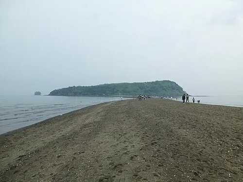 Chiringa Shima Island, Kagoshima18 km W
Sources & licences
Data last updated: · 2 independent sources