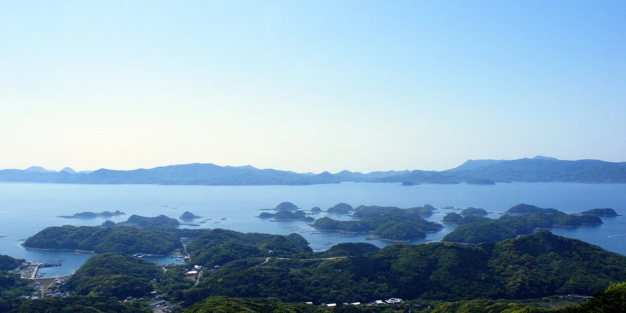
- Population
- 243,223
- 243.2K
- Elevation
- 8 m
- above sea level
- Local time
- UTC+09:00
- Asia/Tokyo · UTC+09:00
- Airports
- NGS Nagasaki Airport33 km
- HSG Kyushu Saga International Airport54 km
About Sasebo
Sasebo is a city. Location: Sasebo Shi, Nagasaki. Population: 243,223. Elevation: 8 m.
Sasebo (佐世保市, Sasebo-shi) is a core city located in Nagasaki Prefecture, Japan. It is the second-largest city in Nagasaki Prefecture, after its capital, Nagasaki. As of 1 April 2024, the city had an estimated population of 230,873 in 102,670 households, and a population density of 540 persons per km2. The total area of the city is 426.01 km2 (164.48 sq mi).
Source: Wikipedia · CC BY-SA 4.0
Photos of Sasebo
-

Masoud Akbari · CC BY-SA 3.0 -

nobu3withfoxy from Iga,Mie, Japan · CC BY 2.0 -

Masoud Akbari · CC BY-SA 3.0


Travel notes for Sasebo
From Wikivoyage
Sasebo (佐世保) is the second-largest city in Nagasaki prefecture on the island of Kyushu, Japan. It is the home of Huis ten Bosch (Hausu ten Bosu), a Dutch-themed amusement park
Understand+
Sasebo is home to the U.S. Navy base, Fleet Activities Sasebo (FAS), and a base for the Japan Self-Defense Force. Sasebo is very English-ready for travels and a great place to slow down and enjoy Japan. While most Japanese cities are very busy Sasebo is calm and Japanese at the same time. The U.S. Navy has accommodation for military on base and veterans. There are about 5000 sailors and marines stationed in Sasebo and there is a designated area of Sasebo downtown known as Sailor Town. It's small and frequented by U.S. service members.
Tourist information site:
The local tourist association has a Japanese-only guide site, which also covers nearby islands town, Ojika (小値賀).
Get in+
By plane:
The nearest airport is in Nagasaki (Omura Airport, 30 min to 1 hour away from Nagasaki by car) from which you can reach Sasebo by bus (80 minutes, ¥1350). Another nearby airport is in Fukuoka, from which you can reach Sasebo by bus (about 2 hours, ¥2200).
By train:
Sasebo, the terminating station on the JR Omura Line, is the westernmost point on the entire Japan Railway.
Sasebo is connected to Hakata station, the last stop on the San'yo Shinkansen in Fukuoka, by the Midori limited express train. The train reaches Sasebo in 1 hr 45 min, reversing direction at Haiki station, and the trip costs ¥2350 each way if booked online up to day of departure (¥2050 if booked 3 days in advance) or ¥4500 if booked in person at a ticket counter or ticket machine (Nov 2024). While the online booking system is not yet available in English, Google Translate or a basic knowledge of Japanese is sufficient and will save you significantly. In addition, online booking allows you to obtain an e-ticket with a QR code to scan at the ticket gates and on board, saving time at the station.
Local trains from Hakata cost only ¥2070, but can take anywhere from 3 to 4 hours, requiring a multiple change of trains; in which case, you're better off using the bus (see below) or spending a little more for the express train (see above). For a day trip you can also consider purchasing a JR Kyushu 1 day pass from a ticket shop for ¥3000-3500. If you still want to use the local trains, Sasebo is also connected to Nagasaki by the hourly Sea Side Liner rapid train (100 minutes, ¥1600, Nov 2024).
By bus:
Frequent highway buses connect the Hakata bus terminal in Fukuoka to Sasebo (about 2 hours, ¥2310 one-way or ¥4400 return). Bus tickets can be booked online here; online booking is generally cheaper (¥2260 one-way, ¥4160 return, or ¥7180 for a set of 4 tickets usable in either direction). (Prices as of Nov 2024.)
Source: Wikivoyage · CC BY-SA 4.0 · abridged
Places bordering Sasebo
- Matsuura
- Hirado
- Saikai Shi
- Saza-cho
- Kawatana
- Hasami Chō
- Imarichō-kō
- Arita Chō
Twin towns and sister cities of Sasebo
- Albuquerque· United States
Source: Wikidata. Only places with a page on this site are shown.
Population of Sasebo over time
| 2010 | 261,101 | |
|---|---|---|
| 2015 | 255,439 | |
| 2021 | 242,664 |
Censuses and official estimates; source: Wikidata.
Climate of Sasebo
Best months for sightseeingBest months for sightseeing: May, October.
This month · November
Outside the best season
Day 17° · Night 10° · Rain 94 mm
Better nearby cities in November
- Beppu · 165 km east17°
- Ōita · 175 km east18°
- Kirishima · 186 km southeast19°
- Hottest month
- August (day 31°)
- Coldest month
- January (night 3°)
- Wettest month
- July (360 mm)
- Driest month
- December (69 mm)
Bars: average monthly low and high temperature. Below: precipitation. Monthly averages for 1970–2000 at about 18 km resolution, adjusted for elevation. Highlighted months are mild and relatively dry. Source: WorldClim 2.1 (CC BY 4.0).
Show values as a table
| Month | Jan | Feb | Mar | Apr | May | Jun | Jul | Aug | Sep | Oct | Nov | Dec |
|---|---|---|---|---|---|---|---|---|---|---|---|---|
| Average high (°C) | 9° | 10° | 14° | 19° | 23° | 26° | 29° | 31° | 27° | 23° | 17° | 12° |
| Average low (°C) | 3° | 4° | 6° | 11° | 15° | 19° | 24° | 25° | 21° | 16° | 10° | 5° |
| Precipitation (mm) | 81 | 91 | 135 | 189 | 196 | 345 | 360 | 206 | 225 | 108 | 94 | 69 |
How to get to Sasebo
The nearest airport is Nagasaki Airport (NGS), 33 km to the southeast as the crow flies. The nearest large city is Karatsu, 38 km to the northeast.
Airports
- Nagasaki Airport (NGS) Nagasaki 33 kmsoutheast
- Kyushu Saga International Airport (HSG) Saga 54 kmeast
- Iki Airport (IKI) Iki 65 kmnorth
Nearby large cities
- Karatsu Population: 117.7K 38 kmnortheast
- Isahaya Population: 135.5K 47 kmsoutheast
- Nagasaki Population: 409.1K 49 kmsouth
- Saga Population: 233.3K 54 kmeast
- Omuta Population: 132K 69 kmeast
Straight-line distances; road distances are longer. Airport data: OurAirports.
Day trips from Sasebo
Within 100 km: 16 historic and cultural sites, 13 natural sites, 22 lakes, rivers and coasts.
0–25 km2 places
- Hario Jima Island 8 kmSE
- Kitamatsuura Hantō Natural site 14 kmN
25–60 km13 places
- Iō Jima Island 52 kmS
- Niji no Matsubara Natural site 41 kmNE
- Kakara Shima Island 49 kmN
- Karatsu Castle Historic site 39 kmNE
60–100 km36 places
- Shimoshima Island Island 99 kmS
- Goto Group Island 78 kmSW
- Iki Island Island 69 kmN
- Mount Unzen Mountain 70 kmSE
Straight-line distances.
Sasebo and similar cities
Side by side with cities of similar size in the same country: population, elevation and climate.
| Measure | Sasebo | Chigasaki | Chōfu | Yamato |
|---|---|---|---|---|
| Population | 243.2K | 242.8K | 242.6K | 242.1K |
| Elevation | 8 m | 6 m | 44 m | 53 m |
| Summer day (hottest month) | 31° | 31° | 30° | 30° |
| Winter night (coldest month) | 3° | 1° | 0° | 0° |
| Annual rainfall | 2,099 mm | 1,663 mm | 1,545 mm | 1,663 mm |
| Best months | May, Oct | Apr–Jun, Oct | May–Jun, Oct | May–Jun, Oct |
| Distance | — | 923 km | 944 km | 930 km |
Climate values are 1970–2000 monthly averages; straight-line distance.
Nearby attractions & nature
Everything nearby-
Hario Jima Island, Nagasaki7.6 km SE
-
Kitamatsuura Hantō Natural site, Nagasaki14 km N
Sources & licences
Data last updated: · 2 independent sources