Kumejima Town
Local name: 久米島町
Located in Shimajiri-gun, Okinawa Coordinates: 26°22′00″ N 126°46′13″ E
- Population
- 8,395
- 8.4K
- Elevation
- 156 m
- above sea level
- Local time
- UTC+09:00
- Asia/Tokyo · UTC+09:00
- Airports
- UEO Kumejima Airport6 km
- OKA Naha International Airport89 km
About Kumejima Town
Kumejima Town is a municipality. Location: Shimajiri-gun, Okinawa. Population: 8,395. Elevation: 156 m.
Kumejima (Japanese: 久米島町, Hepburn: Kumejima-chō; Okinawan: Kumishima) is a town located in Shimajiri District, Okinawa Prefecture, Japan. The town consists of the islands of Kume, Ōjima, Ōhajima, Torishima, and Iōtorishima. Among the islands, only Kumejima and Ōjima are populated. Kumejima is located approximately 100 kilometres (62 mi) west of Naha. The town can be accessed by the New Kumejima Ferry, Japan Transocean Air, or Ryukyu Air Commuter. Kumejima Airport serves the island.
Source: Wikipedia · CC BY-SA 4.0
At a glance
- Built
- 2002
- Heritage designation
- Ramsar site
- Area
- 63.6 km²
- Official website
- town.kumejima.okinawa.jp
Source: Wikidata
Photos of Kumejima Town
-
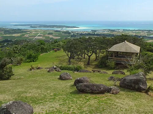
Kume Jima 松岡明芳 · CC BY-SA 3.0

Travel notes for Kumejima Town
From Wikivoyage
Kumejima (久米島), or simply Kume (久米), is an island in Okinawa, Japan, about 100 km west of the main Okinawa Island.
Understand+
Often described as one of the most beautiful islands in Okinawa, Kume has plentiful freshwater supplies and was known for its cultivation of rice. Thanks to its location along the route from mainland China to Okinawa, it was also an important trading post during the days of Ryukyu Kingdom.
Today the island's main industry is tourism, drawing visitors for its beaches, particularly the 5 km long coral cay at its eastern end, and scuba diving. The island is administered as one municipality, Kumejima Town.
Tourist information site:
The local tourist association has a Japanese-only guide site with integrated machine translation.
Get in+
By plane:
1 Kumejima Airport. (UEO IATA) has daily flights from Naha on Japan Transocean Air and Ryukyu Air Commuter (35mins one way, ¥10,000). During the summer months of July and August, Japan Transocean Air also operates once a day flights direct to and from Tokyo's Haneda Airport.
By ferry:
The Kume Shosen runs twice daily from Naha's Tomarin Port to Kumejima's Kanegusuku Port (departs 8:30am and 2:00pm, approximately 3.5 hours, ¥6,450 roundtrip). The morning ferry daily stops at Tonaki on the way, adding 30 min to the journey.
Source: Wikivoyage · CC BY-SA 4.0 · abridged
Population of Kumejima Town over time
| 2010 | 8,519 | |
|---|---|---|
| 2015 | 7,755 | |
| 2021 | 7,180 |
Censuses and official estimates; source: Wikidata.
Climate of Kumejima Town
Best months for sightseeingBest months for sightseeing: March–May, October–December.
This month · November
A good month to visit
Day 23° · Night 19° · Rain 143 mm
- Hottest month
- July (day 30°)
- Coldest month
- January (night 13°)
- Wettest month
- August (253 mm)
- Driest month
- December (118 mm)
Bars: average monthly low and high temperature. Below: precipitation. Monthly averages for 1970–2000 at about 18 km resolution, adjusted for elevation. Highlighted months are mild and relatively dry. Source: WorldClim 2.1 (CC BY 4.0).
Show values as a table
| Month | Jan | Feb | Mar | Apr | May | Jun | Jul | Aug | Sep | Oct | Nov | Dec |
|---|---|---|---|---|---|---|---|---|---|---|---|---|
| Average high (°C) | 18° | 18° | 20° | 23° | 25° | 28° | 30° | 30° | 29° | 26° | 23° | 20° |
| Average low (°C) | 13° | 13° | 15° | 18° | 21° | 24° | 25° | 25° | 24° | 22° | 19° | 15° |
| Precipitation (mm) | 137 | 131 | 169 | 180 | 237 | 247 | 178 | 253 | 217 | 178 | 143 | 118 |
Other places to visit in this season: March April May October November December
How to get to Kumejima Town
The nearest airport is Kumejima Airport (UEO), 6 km to the west as the crow flies. For international flights: Naha International Airport (OKA) (89 km). The nearest large city is Naha, 92 km to the east.
Airports
- Kumejima Airport (UEO) Kumejima 6 kmwest
- Naha International Airport (OKA) Naha 89 kmeast
- Yoron Airport (RNJ) Yoron 179 kmnortheast
Nearby large cities
- Naha Population: 317.6K 92 kmeast
- Urasoe Population: 115.7K 97 kmeast
- Ginowan Population: 100.1K 100 kmeast
- Okinawa Population: 142.8K 103 kmeast
- Uruma Population: 125.3K 109 kmeast
Straight-line distances; road distances are longer. Airport data: OurAirports.
Day trips from Kumejima Town
Within 100 km: 1 historic or cultural site, 12 lakes, rivers and coasts.
0–25 km1 place
- Kume Jima Island 2 kmS
25–60 km8 places
- Kerama Islands Island 59 kmE
- Zamami Island Island 55 kmE
- Aka Island Island 54 kmE
- Fukaji Island Island 56 kmSE
60–100 km4 places
- Kokuba Gawa River 94 kmE
- Mae Shima Island 70 kmE
- Tokashiki Jima Island 61 kmE
- Shuri Castle Historic site 96 kmE
Straight-line distances.
Sources & licences
Data last updated: · 2 independent sources