Minamidaitō Village
Local name: 南大東村
Located in Shimajiri-gun, Okinawa Coordinates: 25°50′35″ N 131°14′34″ E
- Population
- 1,295
- 1.3K
- Elevation
- 2 m
- above sea level
- Local time
- UTC+09:00
- Asia/Tokyo · UTC+09:00
- Airports
- MMD Minamidaito Airport2 km
- KTD Kitadaito Airport14 km
About Minamidaitō Village
Minamidaitō Village is a municipality. Location: Shimajiri-gun, Okinawa. Population: 1,295. Elevation: 2 m.
Minamidaitō (南大東村, Minamidaitō-son) is a village located entirely on Minamidaitōjima in Shimajiri District, Okinawa Prefecture, Japan. Minamidaitōjima is located approximately 360 kilometres (220 mi) east of Okinawa Island. Minamidaitō covers 30.7 square kilometres (11.9 mi2). As of June 2013, the city had a population of 1,418 and a population density of 46.4 people per km2.
Source: Wikipedia · CC BY-SA 4.0
Photos of Minamidaitō Village
-
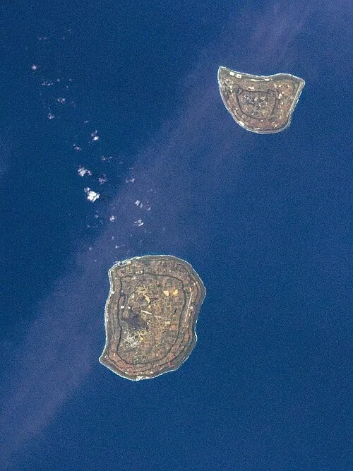
Daitō Islands Image Science and Analysis Laboratory, NASA-Johnson Space Center. "The Gateway to Astronaut Photography of Earth." · Public domain -
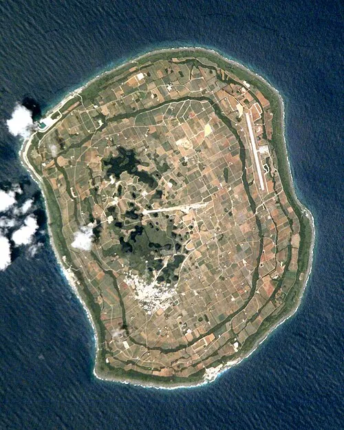
Borodino Island NASA Johnson Space Center · Public domain


Travel notes for Minamidaitō Village
From Wikivoyage
Minamidaitō is a village on an island of the same name in the Japanese prefecture of Okinawa. Other than its tiny neighbor Kitadaito, the nearest land is Okinawa island, about 400 km (240 mi) to the west. The island is known as Minamidaitō-jima (南大東島) and the village is Minamidaitō-son (南大東村). The name is also sometimes written as Minami Daito, or Minamidaitou. With 1400 inhabitants, it has about twice the population of nearby Kitadaito.
Minamidaito island was probably first discovered by the Spanish explorers in the 16th century. Later in 1820, it was found by a Russian sail ship Borodino and named South Borodino Island. The sharp cliffs surrounding it completely made it inaccessible to humans, until in 1900 a Japanese pioneering team from Hachijō Island became its first inhabitants, using it to grow sugarcane. Minamidaito continues to produce sugarcane as its main source of revenue; it also runs factories for refining the sugar and producing a unique brand of rum called Cor Cor.
As a tourist destination, Minamidaito is one for the adventurous - flight tickets are not cheap and ferries are few, but the fascinating ethnic nature, culture and hospitality of the place can easily make it worth the cost, even just for a weekend visit. Everything about Minamidaito is unique, from the unique cultural blend between Okinawa and its ancestral Hachijo to its unique fauna and flora. It is also home to Japan's largest weather station and Japan's shortest airline flight.
Get in+
The only way to get to Minamidaito is from Naha or neighboring Kitadaito either by plane or ferry. There are two flights per day from Naha, which can be reserved up to two months in advance from Naha Airport or by telephone or internet with Japan Airlines. Flights last about 70 minutes and cost ¥31,600 for a roundtrip (in 2011) or ¥24,900 for one way. The ferry costs around ¥10,000 for a roundtrip, but sails only once per week and takes 15–17 hours each way. The timetable is decided about a month before. Check with Daito Line (homepage in Japanese only).
The flight between Minamidaito and Kitadaito lasts for 3 minutes or 15 minutes counting takeoff and landing, and is the shortest airline flight in Japan. At ¥8,300 it is comparatively no doubt the most expensive too.
Source: Wikivoyage · CC BY-SA 4.0 · abridged
Population of Minamidaitō Village over time
| 2010 | 1,442 | |
|---|---|---|
| 2015 | 1,329 | |
| 2021 | 1,331 |
Censuses and official estimates; source: Wikidata.
Climate of Minamidaitō Village
Best months for sightseeingBest months for sightseeing: November–May.
This month · November
A good month to visit
Day 25° · Night 20° · Rain 206 mm
- Hottest month
- July (day 31°)
- Coldest month
- January (night 15°)
- Wettest month
- May (277 mm)
- Driest month
- January (150 mm)
Bars: average monthly low and high temperature. Below: precipitation. Monthly averages for 1970–2000 at about 18 km resolution, adjusted for elevation. Highlighted months are mild and relatively dry. Source: WorldClim 2.1 (CC BY 4.0).
Show values as a table
| Month | Jan | Feb | Mar | Apr | May | Jun | Jul | Aug | Sep | Oct | Nov | Dec |
|---|---|---|---|---|---|---|---|---|---|---|---|---|
| Average high (°C) | 21° | 21° | 22° | 25° | 27° | 29° | 31° | 31° | 31° | 28° | 25° | 22° |
| Average low (°C) | 15° | 15° | 17° | 19° | 22° | 24° | 26° | 26° | 25° | 23° | 20° | 17° |
| Precipitation (mm) | 150 | 156 | 192 | 227 | 277 | 273 | 189 | 203 | 205 | 229 | 206 | 155 |
Other places to visit in this season: January February March April May November December
How to get to Minamidaitō Village
The nearest airport is Minamidaito Airport (MMD), 2 km to the east as the crow flies. The nearest large city is Uruma, 344 km to the west.
Airports
- Minamidaito Airport (MMD) Minamidaito 2 kmeast
- Kitadaito Airport (KTD) Kitadaitōjima 14 kmnortheast
Nearby large cities
- Uruma Population: 125.3K 344 kmwest
- Okinawa Population: 142.8K 349 kmwest
- Ginowan Population: 100.1K 351 kmwest
- Urasoe Population: 115.7K 355 kmwest
- Naha Population: 317.6K 359 kmwest
Straight-line distances; road distances are longer. Airport data: OurAirports.
Day trips from Minamidaitō Village
Within 100 km: 3 lakes, rivers and coasts.
0–25 km3 places
- Daitō Islands Island 7 kmNE
- Borodino Island Island 1 kmSW
- Kitadaitō Jima Island 13 kmNE
Straight-line distances.
Nearby attractions & nature
Everything nearby-
Borodino Island Island, Okinawa0.4 km SW
-
Daitō Islands Island, Okinawa6.5 km NE
-
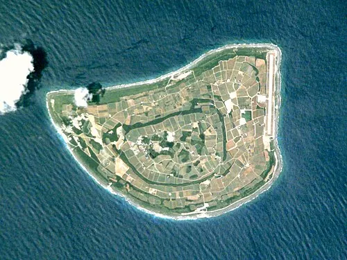 Kitadaitō Jima Island, Okinawa13 km NE
Sources & licences
Data last updated: · 2 independent sources