- Elevation
- 36 m
- above sea level
- Local time
- UTC+09:00
- Asia/Tokyo · UTC+09:00
- Airports
- HSG Kyushu Saga International Airport35 km
- NGS Nagasaki Airport49 km
About Ōchichō-ōchi
Ōchichō-ōchi is a village. Location: Karatsu Shi, Saga Prefecture. Elevation: 36 m.
Ōchi (相知町, Ōchi-chō) was a town located in the Higashimatsuura District of Saga Prefecture, Japan. Ōchi is also romanized as Ouchi and is often referred to that way in Japan. Ōchi was founded as Ōchi-mura (Ōchi-village) by the amalgamation of 16 smaller villages in 1889. It became Ōchi-town (Ōchi-chō) in 1935. Ōchi thus had its own town hall. As of 2003, the town had an estimated population of 8,890 and a density of 136.60 persons per km². The total area was 65.08 km².
Source: Wikipedia · CC BY-SA 4.0
At a glance
- Built
- 1935
Source: Wikidata
Climate of Ōchichō-ōchi
Best months for sightseeingBest months for sightseeing: May–June, October.
This month · November
Outside the best season
Day 17° · Night 10° · Rain 85 mm
Better nearby cities in November
- Beppu · 139 km east17°
- Ōita · 149 km east18°
- Nobeoka · 177 km southeast18°
- Hottest month
- August (day 30°)
- Coldest month
- January (night 3°)
- Wettest month
- July (367 mm)
- Driest month
- December (69 mm)
Bars: average monthly low and high temperature. Below: precipitation. Monthly averages for 1970–2000 at about 18 km resolution, adjusted for elevation. Highlighted months are mild and relatively dry. Source: WorldClim 2.1 (CC BY 4.0).
Show values as a table
| Month | Jan | Feb | Mar | Apr | May | Jun | Jul | Aug | Sep | Oct | Nov | Dec |
|---|---|---|---|---|---|---|---|---|---|---|---|---|
| Average high (°C) | 9° | 10° | 13° | 18° | 23° | 25° | 29° | 30° | 27° | 22° | 17° | 12° |
| Average low (°C) | 3° | 3° | 6° | 11° | 15° | 19° | 24° | 24° | 21° | 15° | 10° | 5° |
| Precipitation (mm) | 79 | 91 | 134 | 175 | 187 | 349 | 367 | 210 | 234 | 107 | 85 | 69 |
How to get to Ōchichō-ōchi
The nearest airport is Kyushu Saga International Airport (HSG), 35 km to the southeast as the crow flies. The nearest large city is Karatsu, 11 km to the north.
Airports
- Kyushu Saga International Airport (HSG) Saga 35 kmsoutheast
- Nagasaki Airport (NGS) Nagasaki 49 kmsouth
- Fukuoka Airport (FUK) Fukuoka 49 kmnortheast
Nearby large cities
- Karatsu Population: 117.7K 11 kmnorth
- Saga Population: 233.3K 30 kmsoutheast
- Sasebo Population: 243.2K 33 kmsouthwest
- Kasuga Population: 111K 47 kmnortheast
- Kurume Population: 303.6K 48 kmeast
Straight-line distances; road distances are longer. Airport data: OurAirports.
Nearby attractions & nature
Everything nearby-
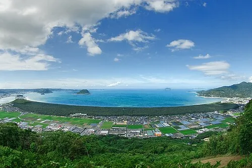 Niji no Matsubara Natural site, Saga Prefecture11 km N
-
 Karatsu Castle Historic site, Karatsu Shi12 km N
Sources & licences
Data last updated: · 2 independent sources