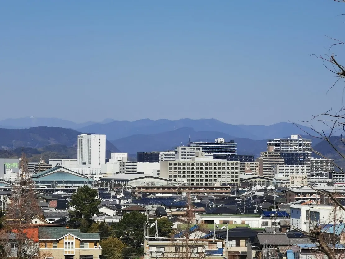
- Population
- 145,032
- 145K
- Elevation
- 22 m
- above sea level
- Local time
- UTC+09:00
- Asia/Tokyo · UTC+09:00
- Airports
- FSZ Mount Fuji Shizuoka Airport11 km
- OIM Oshima Airport100 km
About Fujieda
Fujieda is a city. Location: Fujieda Shi, Shizuoka. Population: 145,032. Elevation: 22 m.
Fujieda (藤枝市, Fujieda-shi) is a city located in Shizuoka Prefecture, Japan. As of 30 April 2019, the city has an estimated population of 145,032 in 59,480 households, and a population density of 750 persons per km2. The total area of the city was 194.06 square kilometres (74.93 sq mi). Fujieda is a member of the World Health Organization’s Alliance for Healthy Cities (AFHC).
Source: Wikipedia · CC BY-SA 4.0
Photos of Fujieda
-

Halowand · CC BY-SA 4.0 -
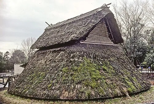
Toro Iseki Wikimedia Commons · Public domain


Travel notes for Fujieda
From Wikivoyage
Shizuoka (静岡) is the capital city of Shizuoka prefecture in Japan's Chubu region. In 2005, Shizuoka absorbed the neighboring city of Shimizu (清水).
Understand+
Tourist information site:
The local tourist association has a Japanese-only guide site with integrated machine translation.
Get in+
Shizuoka is a stop on the Tokaido Main Line and Tokaido Shinkansen Line between Tokyo and Osaka, and on the Tomei Expressway.
By plane:
1 Mt. Fuji Shizuoka Airport (FSZ IATA), 〒421-0411 静岡県牧之原市坂口3336番地4 (Makinohara and Shimada), ☏ +81 548-29-2000. Fuji Dream Airlines is based at the airport, operating flights to Sapporo, Fukuoka and Kagoshima. All Nippon Airways operates flights to Sapporo and Okinawa. International flights operate to and from China, Hong Kong, and South Korea.
Buses run from Mt. Fuji Shizuoka Airport to the Shizuoka train station in about an hour at a cost of ¥1000. While the airport was built right over the Tokaido Shinkansen line, there is no train station serving the airport.
The nearest major airports are Haneda and Narita Airports in Tokyo, and Chubu International Airport in Nagoya. It takes approximately two hours to reach Shizuoka from Haneda or Chubu on the fastest train services, a little longer from Narita.
By train:
The Tokaido Shinkansen runs one Hikari train per hour which stops at Shizuoka (and pauses for about 5 minutes while faster Nozomi trains barrel through the station). It is one hour from Tokyo (¥6350), 50 minutes from Nagoya (¥6350), 90 minutes from Kyoto (¥10240), and 1 hr 45 min from Shin-Osaka (¥10880) using this train.
Source: Wikivoyage · CC BY-SA 4.0 · abridged
Places bordering Fujieda
- Shizuoka
- Yaizu
- Shimada
Twin towns and sister cities of Fujieda
- Eniwa-shi· Japan
- Kōnan· Japan
Source: Wikidata. Only places with a page on this site are shown.
Population of Fujieda over time
| 2010 | 142,151 | |
|---|---|---|
| 2015 | 143,605 | |
| 2021 | 140,947 |
Censuses and official estimates; source: Wikidata.
Climate of Fujieda
Best months for sightseeingBest months for sightseeing: May–June, September–October.
This month · November
A wet month
Day 18° · Night 9° · Rain 123 mm
Better nearby cities in November
- Fujinomiya · 50 km northeast18°
- Fuji · 51 km northeast20°
- Numazu · 61 km northeast18°
- Hottest month
- August (day 30°)
- Coldest month
- January (night 2°)
- Wettest month
- June (293 mm)
- Driest month
- December (70 mm)
Bars: average monthly low and high temperature. Below: precipitation. Monthly averages for 1970–2000 at about 18 km resolution, adjusted for elevation. Highlighted months are mild and relatively dry. Source: WorldClim 2.1 (CC BY 4.0).
Show values as a table
| Month | Jan | Feb | Mar | Apr | May | Jun | Jul | Aug | Sep | Oct | Nov | Dec |
|---|---|---|---|---|---|---|---|---|---|---|---|---|
| Average high (°C) | 11° | 11° | 14° | 19° | 22° | 25° | 29° | 30° | 27° | 22° | 18° | 13° |
| Average low (°C) | 2° | 2° | 5° | 10° | 14° | 19° | 22° | 23° | 20° | 15° | 9° | 4° |
| Precipitation (mm) | 77 | 99 | 177 | 208 | 209 | 293 | 237 | 236 | 259 | 186 | 123 | 70 |
Other places to visit in this season: May June September October
How to get to Fujieda
The nearest airport is Mount Fuji Shizuoka Airport (FSZ), 11 km to the southwest as the crow flies. The nearest large city is Yaizu, 5 km to the east.
Airports
- Mount Fuji Shizuoka Airport (FSZ) Makinohara / Shimada 11 kmsouthwest
- Oshima Airport (OIM) Izu Oshima 100 kmeast
- Nagoya Airport / JASDF Komaki Air Base (NKM) Nagoya 130 kmwest
Nearby large cities
- Yaizu Population: 139.6K 5 kmeast
- Shizuoka Population: 693.4K 17 kmnortheast
- Kakegawa Population: 117.9K 25 kmsouthwest
- Iwata Population: 166.7K 42 kmsouthwest
- Fujinomiya Population: 132.5K 50 kmnortheast
Straight-line distances; road distances are longer. Airport data: OurAirports.
Day trips from Fujieda
Within 100 km: 2 historic and cultural sites, 22 natural sites, 17 lakes, rivers and coasts.
0–25 km3 places
- Oi River River 12 kmS
- Abe River River 14 kmNE
- Toro Iseki Historic site 16 kmNE
25–60 km9 places
- Suruga Bay Natural site 26 kmE
- Fuji River River 44 kmNE
- Mount Tekari Mountain 54 kmN
- Mount Akiha Mountain 39 kmW
60–100 km29 places
- Hatsu-shima Island 85 kmE
- Lake Shoji Lake 76 kmNE
- Mount Senjō Mountain 95 kmN
- Mount Aino Mountain 87 kmN
Straight-line distances.
Fujieda and similar cities
Side by side with cities of similar size in the same country: population, elevation and climate.
| Measure | Fujieda | Ashikaga | Kakamigahara | Tsuchiura |
|---|---|---|---|---|
| Population | 145K | 144.7K | 144.5K | 144.4K |
| Elevation | 22 m | 45 m | 40 m | 5 m |
| Summer day (hottest month) | 30° | 30° | 31° | 29° |
| Winter night (coldest month) | 2° | -2° | -1° | -2° |
| Annual rainfall | 2,174 mm | 1,243 mm | 2,087 mm | 1,348 mm |
| Best months | May–Jun, Sep–Oct | May, Oct | May–Jun, Oct | May–Jul, Sep–Oct |
| Distance | — | 195 km | 141 km | 223 km |
Climate values are 1970–2000 monthly averages; straight-line distance.
Nearby attractions & nature
Everything nearby-
Oi River River, Shizuoka12 km S
-
Toro Iseki Historic site, Suruga Ku16 km NE
-
Abe River River, Shizuoka14 km NE
Sources & licences
Data last updated: · 2 independent sources