- Population
- 315
- 315
- Elevation
- 840 m
- above sea level
- Local time
- UTC+09:00
- Asia/Tokyo · UTC+09:00
- Places inside
- 1
- listed under Mikurajima Mura
- Airports
- MYE Miyakejima Airport22 km
- HAC Hachijojima Airport86 km
About Mikurajima Mura
Mikurajima Mura is a municipality. Location: Miyake-shichō, Tokyo. Population: 315. Elevation: 840 m. The best months to visit are June–September. The nearest airport is Miyakejima Airport (22 km).
Photos of Mikurajima Mura
-
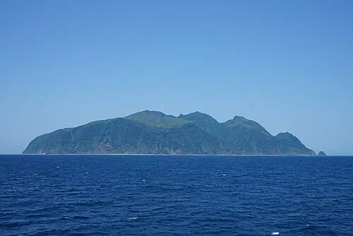
Mikura-jima Izawa Ryu · CC BY-SA 4.0

Climate of Mikurajima Mura
Best months for sightseeingBest months for sightseeing: June–September.
This month · November
A wet month
Day 15° · Night 10° · Rain 222 mm
Better nearby cities in November
- Mishima · 152 km northwest18°
- Numazu · 152 km northwest18°
- Odawara · 159 km north19°
- Hottest month
- August (day 24°)
- Coldest month
- February (night 3°)
- Wettest month
- October (328 mm)
- Driest month
- December (130 mm)
Bars: average monthly low and high temperature. Below: precipitation. Monthly averages for 1970–2000 at about 18 km resolution, adjusted for elevation. Highlighted months are mild and relatively dry. Source: WorldClim 2.1 (CC BY 4.0).
Show values as a table
| Month | Jan | Feb | Mar | Apr | May | Jun | Jul | Aug | Sep | Oct | Nov | Dec |
|---|---|---|---|---|---|---|---|---|---|---|---|---|
| Average high (°C) | 10° | 9° | 11° | 14° | 17° | 20° | 23° | 24° | 22° | 19° | 15° | 12° |
| Average low (°C) | 3° | 3° | 5° | 8° | 12° | 15° | 18° | 19° | 17° | 14° | 10° | 6° |
| Precipitation (mm) | 131 | 152 | 220 | 223 | 250 | 323 | 198 | 239 | 311 | 328 | 222 | 130 |
Other places to visit in this season: June July August September
How to get to Mikurajima Mura
The nearest airport is Miyakejima Airport (MYE), 22 km to the north as the crow flies. The nearest large city is Mishima, 152 km to the northwest.
Airports
- Miyakejima Airport (MYE) Miyakejima 22 kmnorth
- Hachijojima Airport (HAC) Hachijojima 86 kmsouth
- Oshima Airport (OIM) Izu Oshima 103 kmnorth
Nearby large cities
- Mishima Population: 107.9K 152 kmnorthwest
- Numazu Population: 189.5K 152 kmnorthwest
- Yokosuka Population: 409.5K 156 kmnorth
- Odawara Population: 188.9K 158 kmnorth
- Kamakura Population: 172.9K 159 kmnorth
Straight-line distances; road distances are longer. Airport data: OurAirports.
Day trips from Mikurajima Mura
Within 100 km: 1 natural site, 14 lakes, rivers and coasts.
0–25 km2 places
- Miyake Jima Island 25 kmN
- Mikura-jima Island 1 kmN
25–60 km4 places
- Izu Islands Island 51 kmN
- Kōzu Shima Island 56 kmNW
- Ōnohara Jima Island 28 kmNW
- Inamba-jima Island 37 kmSW
60–100 km9 places
- Hachijojima Island Island 86 kmS
- Ō Shima Island 97 kmN
- Nii-jima Island 64 kmNW
- Shikine-jima Island 62 kmNW
Straight-line distances.
Places in Mikurajima Mura
1 place-
Mikura-jima
Population: 351
Sources & licences
Data last updated: