- Population
- 6,222
- 6.2K
- Elevation
- 325 m
- above sea level
- Local time
- UTC+09:00
- Asia/Tokyo · UTC+09:00
- Places inside
- 1
- listed under Kaneyama Machi
- Airports
- SYO Shonai Airport52 km
- GAJ Yamagata Airport55 km
About Kaneyama Machi
Kaneyama Machi is a municipality. Location: Mogami-gun, Yamagata. Population: 6,222. Elevation: 325 m. The best months to visit are May–July, September. The nearest airport is Shonai Airport (52 km).
Climate of Kaneyama Machi
Best months for sightseeingBest months for sightseeing: May–July, September.
This month · November
A wet month
Day 10° · Night 2° · Rain 144 mm
Better nearby cities in November
- Kofu · 394 km southwest17°
- Hottest month
- August (day 28°)
- Coldest month
- February (night -6°)
- Wettest month
- August (182 mm)
- Driest month
- March (94 mm)
Bars: average monthly low and high temperature. Below: precipitation. Monthly averages for 1970–2000 at about 18 km resolution, adjusted for elevation. Highlighted months are mild and relatively dry. Source: WorldClim 2.1 (CC BY 4.0).
Show values as a table
| Month | Jan | Feb | Mar | Apr | May | Jun | Jul | Aug | Sep | Oct | Nov | Dec |
|---|---|---|---|---|---|---|---|---|---|---|---|---|
| Average high (°C) | 1° | 1° | 4° | 12° | 18° | 22° | 26° | 28° | 23° | 17° | 10° | 4° |
| Average low (°C) | -5° | -6° | -3° | 3° | 9° | 14° | 18° | 19° | 15° | 8° | 2° | -2° |
| Precipitation (mm) | 130 | 102 | 94 | 108 | 100 | 133 | 176 | 182 | 167 | 134 | 144 | 140 |
Other places to visit in this season: May June July September
How to get to Kaneyama Machi
The nearest airport is Shonai Airport (SYO), 52 km to the west as the crow flies. The nearest large city is Sakata, 45 km to the west.
Airports
- Shonai Airport (SYO) Shonai 52 kmwest
- Yamagata Airport (GAJ) Higashine 55 kmsouth
- Akita Airport (AXT) Akita 80 kmnorth
Nearby large cities
- Sakata Population: 100.3K 45 kmwest
- Tsuruoka Population: 125.4K 52 kmsouthwest
- Ōsaki Population: 128.8K 63 kmsoutheast
- Ichinoseki Population: 114.5K 66 kmeast
- Ōshū Population: 112.9K 74 kmeast
Straight-line distances; road distances are longer. Airport data: OurAirports.
Day trips from Kaneyama Machi
Within 100 km: 3 historic and cultural sites, 11 natural sites, 16 lakes, rivers and coasts.
25–60 km9 places
- Mount Funagata Mountain 54 kmSE
- Haguro Yama Mountain 40 kmSW
- Mount Chōkai Mountain 36 kmNW
- Mount Yudono Mountain 53 kmSW
60–100 km21 places
- Miyago Jima Island 93 kmSE
- Tobi Shima Island 78 kmNW
- Koyoshi River River 62 kmNW
- Zuigan Ji Attraction 84 kmSE
Straight-line distances.
Places in Kaneyama Machi
1 place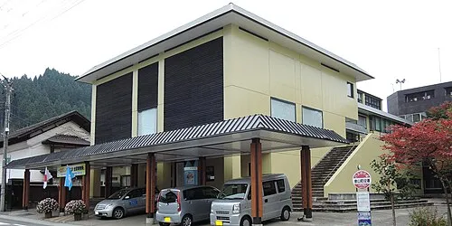
Kaneyama
Population: 5.2K
Sources & licences
Data last updated: