Serra de Santo António
Located in Capinha, Fundão Municipality Coordinates: 40°13′07″ N 7°22′10″ W
- Elevation
- 640 m
- above sea level
- Local time
- UTC+00:00
- Europe/Lisbon · UTC+00:00
- Airports
- VSE Aerodromo Goncalves Lobato (Viseu Airport)71 km
- VRL Vila Real Airport121 km
About Serra de Santo António
Serra de Santo António is a mountain. Location: Capinha, Fundão Municipality. Elevation: 640 m. The best months to visit are June–September. The nearest airport is Aerodromo Goncalves Lobato (Viseu Airport) (71 km). Nearby sights include Cabeço do Valongo and Cabeço do Pombal.
Climate of Serra de Santo António
Best months for sightseeingBest months for sightseeing: June–September.
This month · November
A wet month
Day 14° · Night 6° · Rain 130 mm
- Hottest month
- August (day 28°)
- Coldest month
- January (night 3°)
- Wettest month
- January (160 mm)
- Driest month
- July (12 mm)
Bars: average monthly low and high temperature. Below: precipitation. Monthly averages for 1970–2000 at about 18 km resolution, adjusted for elevation. Highlighted months are mild and relatively dry. Source: WorldClim 2.1 (CC BY 4.0).
Show values as a table
| Month | Jan | Feb | Mar | Apr | May | Jun | Jul | Aug | Sep | Oct | Nov | Dec |
|---|---|---|---|---|---|---|---|---|---|---|---|---|
| Average high (°C) | 11° | 12° | 15° | 16° | 19° | 25° | 28° | 28° | 25° | 19° | 14° | 11° |
| Average low (°C) | 3° | 4° | 5° | 6° | 9° | 13° | 15° | 15° | 13° | 10° | 6° | 4° |
| Precipitation (mm) | 160 | 126 | 101 | 87 | 81 | 37 | 12 | 12 | 47 | 111 | 130 | 156 |
Other places to visit in this season: June July August September
How to get to Serra de Santo António
The nearest airport is Aerodromo Goncalves Lobato (Viseu Airport) (VSE), 71 km to the northwest as the crow flies. The nearest large city is Porto, 147 km to the northwest.
Airports
- Aerodromo Goncalves Lobato (Viseu Airport) (VSE) Viseu 71 kmnorthwest
- Vila Real Airport (VRL) Vila Real 121 kmnorth
- Badajoz Airport (BJZ) Badajoz 155 kmsouth
Nearby large cities
- Porto Population: 252.7K 147 kmnorthwest
- Badajoz Population: 150.5K 153 kmsouth
- Salamanca Population: 144.8K 167 kmnortheast
- Braga Population: 193.3K 173 kmnorthwest
- Lisbon Population: 517.8K 226 kmsouthwest
Straight-line distances; road distances are longer. Airport data: OurAirports.
Day trips from Serra de Santo António
Within 100 km: 35 historic and cultural sites, 138 natural sites, 92 lakes, rivers and coasts.
0–25 km10 places
- Serra da Guardunha Mountain 20 kmSW
- Serra da Galega Mountain 19 kmNW
- Serra da Estrela - Torre Mountain 24 kmNW
- Cabeço do Valongo Mountain 6 kmN
25–60 km82 places
- Sierra de Gata Mountain 50 kmE
- Pico Jálama Mountain 52 kmE
- Arroyo de Lágina River 57 kmE
- Río de El Payo River 55 kmE
60–100 km173 places
- Sapateira Grande Mountain 83 kmS
- Pantano de Águeda Lake 83 kmNE
- Las Hurdes Mountain 95 kmE
- Cadenetas Park Natural site 75 kmE
Straight-line distances.
Nearest towns and villages
-
Três Povos Municipality, Fundão Municipality5.6 km E
-
Peraboa Municipality, Covilhã Municipality5.7 km NW
-
Pêro Viseu Municipality, Fundão Municipality5.8 km SW
-
Caria Municipality, Belmonte Municipality7.9 km N
-
Ferro Municipality, Covilhã Municipality7.5 km W
-
Enxames Municipality, Fundão Municipality7.1 km S
Nearby attractions & nature
Everything nearby-
Cabeço do Valongo Mountain, Caria6.2 km N
-
Cabeço do Pombal Mountain, Três Povos6.8 km NE
-
Cabeço de Escarigo Mountain, Três Povos7.3 km NE
-
Cabeço do Vale da Amoreira Mountain, Castelo Branco District13 km NE
-
Serra da Pena Mountain, Sortelha15 km NE
-
Alto da Malhoeira Mountain, Orjais16 km N
-
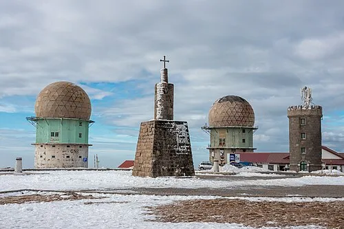 Serra da Estrela - Torre Mountain, Alvoco da Serra24 km NW
-
Serra da Cabeça Alta Mountain, Valhelhas24 km N
Sources & licences
Data last updated: · 2 independent sources