- Local time
- UTC+03:00
- Europe/Istanbul · UTC+03:00
- Elevation
- 1,988 m
- above sea level
- Airports
- EVN Zvartnots International Airport47 km
- IGD Iğdır Airport53 km
About Gömik
Gömik is a historic site. Location: Aralık İlçesi, Iğdır Province. The best months to visit are June–September. The nearest airport is Zvartnots International Airport (47 km). Nearby sights include Tekaltıdağı Tepesi and Kūh-e Ārārāt-e Bozorg.
Climate of Gömik
Best months for sightseeingBest months for sightseeing: June–September.
This month · November
A cold month
Day 6° · Night -3° · Rain 26 mm
Better nearby cities in November
- Silopi · 324 km southwest20°
- Cizre · 329 km southwest20°
- Hottest month
- August (day 26°)
- Coldest month
- January (night -11°)
- Wettest month
- May (66 mm)
- Driest month
- September (17 mm)
Bars: average monthly low and high temperature. Below: precipitation. Monthly averages for 1970–2000 at about 18 km resolution, adjusted for elevation. Highlighted months are mild and relatively dry. Source: WorldClim 2.1 (CC BY 4.0).
Show values as a table
| Month | Jan | Feb | Mar | Apr | May | Jun | Jul | Aug | Sep | Oct | Nov | Dec |
|---|---|---|---|---|---|---|---|---|---|---|---|---|
| Average high (°C) | -3° | -2° | 4° | 11° | 16° | 22° | 26° | 26° | 22° | 14° | 6° | -1° |
| Average low (°C) | -11° | -10° | -5° | 1° | 5° | 9° | 13° | 13° | 8° | 3° | -3° | -8° |
| Precipitation (mm) | 20 | 24 | 32 | 50 | 66 | 48 | 24 | 19 | 17 | 37 | 26 | 21 |
Other places to visit in this season: June July August September
How to get to Gömik
The nearest airport is Zvartnots International Airport (EVN), 47 km to the north as the crow flies. The nearest large city is Iğdır, 38 km to the northwest.
Airports
- Zvartnots International Airport (EVN) Yerevan 47 kmnorth
- Iğdır Airport (IGD) Iğdır 53 kmnorthwest
- Nakhchivan International Airport (NAJ) Nakhchivan 108 kmsoutheast
Nearby large cities
- Iğdır Population: 101.7K 38 kmnorthwest
- Ağrı Population: 124.5K 117 kmwest
- Van Population: 525K 163 kmsouthwest
- Ganja Population: 330.7K 197 kmnortheast
- Rustavi Population: 128.2K 210 kmnorth
Straight-line distances; road distances are longer. Airport data: OurAirports.
Day trips from Gömik
Within 100 km: 7 historic and cultural sites, 118 natural sites, 67 lakes, rivers and coasts.
0–25 km16 places
- Tekaltıdağı Tepesi Mountain 2 kmNE
- Aracık Dağı Mountain 19 kmNW
- Mount Ararat Mountain 10 kmW
- Arpa Tepe Mountain 15 kmNW
25–60 km50 places
- Saz Gölü Lake 30 kmW
- Gölyüzü Gölü Lake 26 kmSW
- Erhacı Gölü Lake 32 kmNW
- Yalıntaşdağı Tepesi Mountain 37 kmW
60–100 km126 places
- Razvaliny Lizbirt Historic site 85 kmE
- Süphan Gölü Lake 97 kmSW
- Lake Balık Lake 72 kmW
- Kazlıgöl Lake 64 kmSW
Straight-line distances.
Nearby attractions & nature
Everything nearby-
Tekaltıdağı Tepesi Mountain, Aralık İlçesi2 km NE
-
Kūh-e Ārārāt-e Bozorg Mountain, Aralık İlçesi8.3 km W
-
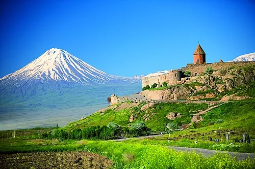 Little Ararat Mountain, Doğubayazıt District8.6 km S
-
Kopgel Mountain, Aralık İlçesi9.3 km W
-
Great Ararat Mountain, Aralık İlçesi9.7 km W
-
Karakaya Tepesi Mountain, Aralık İlçesi8.7 km E
-
Mıhtepe Mountain, Doğubayazıt District9.3 km SW
-
Mount Ararat Mountain, Doğubayazıt District9.8 km W
Nearest towns and villages
-
 Yenidoğan Village, Aralık İlçesi6.1 km NW
-
Bilican Village, Aralık İlçesi3.3 km S
-
Serdarbulak Village, Aralık İlçesi4.8 km S
-
Tarlabaşı Village, Aralık İlçesi7.5 km N
Sources & licences
Data last updated: