Albeştii de Argeş
Located in Comuna Albeștii de Argeș, Arges Coordinates: 45°13′00″ N 24°40′00″ E
- Elevation
- 489 m
- above sea level
- Local time
- UTC+02:00
- Europe/Bucharest · UTC+02:00
- Airports
- SBZ Sibiu International Airport78 km
- GHV Brașov-Ghimbav International Airport86 km
About Albeştii de Argeş
Albeştii de Argeş is a city. Location: Comuna Albeștii de Argeș, Arges. Elevation: 489 m. The best months to visit are May–September. The nearest airport is Sibiu International Airport (78 km). Nearby sights include Poenari Citadel and Valea Areful.
Photos of Albeştii de Argeş
-
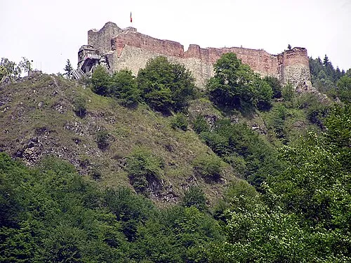
Poenari Citadel L.Kenzel · CC BY-SA 3.0

Climate of Albeştii de Argeş
Best months for sightseeingBest months for sightseeing: May–September.
This month · November
A cold month
Day 8° · Night -1° · Rain 40 mm
- Hottest month
- July (day 24°)
- Coldest month
- January (night -6°)
- Wettest month
- June (95 mm)
- Driest month
- January (30 mm)
Bars: average monthly low and high temperature. Below: precipitation. Monthly averages for 1970–2000 at about 18 km resolution, adjusted for elevation. Highlighted months are mild and relatively dry. Source: WorldClim 2.1 (CC BY 4.0).
Show values as a table
| Month | Jan | Feb | Mar | Apr | May | Jun | Jul | Aug | Sep | Oct | Nov | Dec |
|---|---|---|---|---|---|---|---|---|---|---|---|---|
| Average high (°C) | 3° | 4° | 9° | 14° | 19° | 23° | 24° | 24° | 20° | 15° | 8° | 4° |
| Average low (°C) | -6° | -5° | -2° | 4° | 8° | 12° | 13° | 13° | 9° | 4° | -1° | -4° |
| Precipitation (mm) | 30 | 31 | 33 | 59 | 86 | 95 | 89 | 74 | 51 | 45 | 40 | 36 |
Other places to visit in this season: May June July August September
How to get to Albeştii de Argeş
The nearest airport is Sibiu International Airport (SBZ), 78 km to the northwest as the crow flies. The nearest large city is Piteşti, 44 km to the south.
Airports
- Sibiu International Airport (SBZ) Sibiu 78 kmnorthwest
- Brașov-Ghimbav International Airport (GHV) Brașov (Ghimbav) 86 kmnortheast
- Craiova International Airport (CRA) Craiova 117 kmsouthwest
Nearby large cities
- Piteşti Population: 141.3K 44 kmsouth
- Sibiu Population: 134.3K 76 kmnorthwest
- Brasov Population: 253.2K 88 kmnortheast
- Ploieşti Population: 180.5K 110 kmeast
- Craiova Population: 234.1K 121 kmsouthwest
Straight-line distances; road distances are longer. Airport data: OurAirports.
Day trips from Albeştii de Argeş
Within 100 km: 1 historic or cultural site, 767 natural sites, 3 lakes, rivers and coasts.
0–25 km17 places
- Muntele Clăbucetu Mountain 23 kmN
- Ghitu Mountain 16 kmN
- Clabucet-Nucsoara Mountain 24 kmN
- Muntisor Mountain 19 kmNW
25–60 km457 places
- Coltii Blajeni Mountain 40 kmE
- Valea Râncăciov Natural site 41 kmSE
- Valea Purcăreanca Natural site 33 kmSE
- Valea Negraia Natural site 57 kmSW
60–100 km297 places
- Valea Râul Sadului Natural site 64 kmNW
- Valea Răchita Natural site 86 kmSW
- Valea Plăvaia Natural site 75 kmSW
- Valea Pârâului Natural site 98 kmW
Straight-line distances.
Nearby attractions & nature
Everything nearby-
Poenari Citadel Historic site, Comuna Arefu15 km N
-
Valea Areful Natural site, Romania12 km N
-
Albina Mountain, Comuna Arefu15 km N
-
Ghitu Mountain, Comuna Arefu16 km N
-
Obarsia Mountain, Comuna Arefu16 km N
-
Muntisor Mountain, Comuna Sălătrucu19 km NW
-
Fantanele Mountain, Comuna Arefu22 km N
-
Calugaru Mountain, Comuna Arefu22 km N
Sources & licences
Data last updated: