- Population
- 1,002
- 1K
- Elevation
- 266 m
- above sea level
- Local time
- UTC+02:00
- Europe/Bucharest · UTC+02:00
- Airports
- IAS Iaşi International Airport28 km
- BCM Bacău George Enescu International Airport64 km
About Domnița
Domnița is a village. Location: Comuna Ţibana, Iași County. Population: 1,002. Elevation: 266 m. The best months to visit are May–September. The nearest airport is Iaşi International Airport (28 km). Nearby sights include Church of the Holy Mother of God and Valea Buda.
Climate of Domnița
Best months for sightseeingBest months for sightseeing: May–September.
This month · November
A cold month
Day 7° · Night -1° · Rain 32 mm
- Hottest month
- July (day 26°)
- Coldest month
- January (night -7°)
- Wettest month
- June (90 mm)
- Driest month
- January (24 mm)
Bars: average monthly low and high temperature. Below: precipitation. Monthly averages for 1970–2000 at about 18 km resolution, adjusted for elevation. Highlighted months are mild and relatively dry. Source: WorldClim 2.1 (CC BY 4.0).
Show values as a table
| Month | Jan | Feb | Mar | Apr | May | Jun | Jul | Aug | Sep | Oct | Nov | Dec |
|---|---|---|---|---|---|---|---|---|---|---|---|---|
| Average high (°C) | 0° | 2° | 7° | 15° | 21° | 24° | 26° | 25° | 21° | 14° | 7° | 2° |
| Average low (°C) | -7° | -5° | -1° | 4° | 9° | 13° | 14° | 13° | 9° | 4° | -1° | -4° |
| Precipitation (mm) | 24 | 27 | 29 | 48 | 64 | 90 | 79 | 57 | 50 | 31 | 32 | 31 |
Other places to visit in this season: May June July August September
How to get to Domnița
The nearest airport is Iaşi International Airport (IAS), 28 km to the northeast as the crow flies. The nearest large city is Iași, 26 km to the northeast.
Airports
- Iaşi International Airport (IAS) Iaşi 28 kmnortheast
- Bacău George Enescu International Airport (BCM) Bacău 64 kmsouthwest
- Suceava Ștefan cel Mare International Airport (SCV) Suceava 105 kmnorthwest
Nearby large cities
- Iași Population: 379K 26 kmnortheast
- Bacau Population: 136.1K 60 kmsouthwest
- Piatra Neamţ Population: 102.7K 77 kmwest
- Galati Population: 217.9K 185 kmsouth
- Brăila Population: 154.7K 201 kmsouth
Straight-line distances; road distances are longer. Airport data: OurAirports.
Day trips from Domnița
Within 100 km: 1 historic or cultural site, 30 natural sites, 2 lakes, rivers and coasts.
0–25 km3 places
- Valea Plopoasa Natural site 23 kmS
- Valea Buda Natural site 22 kmNW
- Church of the Holy Mother of God Attraction 25 kmNE
25–60 km8 places
- Valea Oanei Natural site 40 kmS
- Valea Ruginoasa Natural site 34 kmS
- Valea Tătărănilor Natural site 36 kmSE
- Valea Goruni Natural site 32 kmE
60–100 km22 places
- Valea Orbicului Natural site 60 kmSW
- Valea Cârjoani Natural site 78 kmS
- Valea Bogdana Natural site 83 kmS
- Valea Bicaz Natural site 95 kmW
Straight-line distances.
Nearby attractions & nature
Everything nearby-
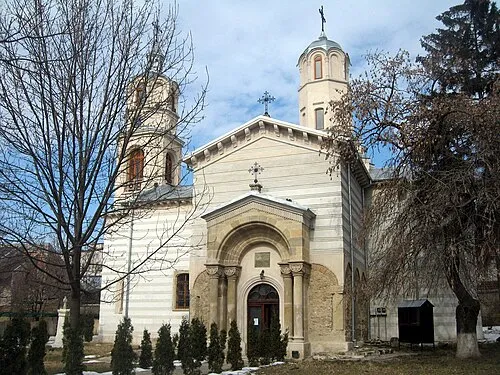 Church of the Holy Mother of God Attraction, Municipiul Iaşi25 km NE
-
Valea Buda Natural site, Romania22 km NW
-
Valea Plopoasa Natural site, Romania23 km S
Sources & licences
Data last updated: