Okres Bratislava I
Located in Bratislava Region, Slovakia Coordinates: 48°08′48″ N 17°06′21″ E
- Population
- 40,610
- 40.6K
- Elevation
- 154 m
- above sea level
- Local time
- UTC+01:00
- Europe/Bratislava · UTC+01:00
- Places inside
- 1
- listed under Okres Bratislava I
- Airports
- BTS M. R. Štefánik Airport8 km
- VIE Vienna International Airport40 km
About Okres Bratislava I
Okres Bratislava I is a district. Location: Bratislava Region, Slovakia. Population: 40,610.
Bratislava I (Slovak: okres Bratislava I; Hungarian: Pozsonyi I. járás) is a district in the city of Bratislava. It is identical with its sole borough, Bratislava's Old Town (Slovak: Staré mesto; German: Altstadt; Hungarian: Óváros). With an area of 10 square kilometers, it is the smallest district of Slovakia. It is completely surrounded by other Bratislava districts: Bratislava II, Bratislava III, Bratislava IV and Bratislava V.
Source: Wikipedia · CC BY-SA 4.0
At a glance
- Area
- 9.6 km²
Source: Wikidata
Photos of Okres Bratislava I
-
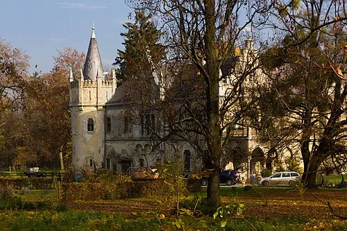
Schloss Walterskirchen Liberaler Humanist · CC BY-SA 4.0

Places bordering Okres Bratislava I
- Okres Bratislava IV
- Okres Bratislava III
- Okres Bratislava II
- Okres Bratislava V
Population of Okres Bratislava I over time
| 2017 | 40,610 | |
|---|---|---|
| 2021 | 46,080 | |
| 2024 | 47,635 | |
| 2025 | 47,896 |
Censuses and official estimates; source: Wikidata.
Climate of Okres Bratislava I
Best months for sightseeingBest months for sightseeing: May–September.
This month · November
A cold month
Day 7° · Night 1° · Rain 52 mm
- Hottest month
- July (day 26°)
- Coldest month
- January (night -4°)
- Wettest month
- June (67 mm)
- Driest month
- February (35 mm)
Bars: average monthly low and high temperature. Below: precipitation. Monthly averages for 1970–2000 at about 18 km resolution, adjusted for elevation. Highlighted months are mild and relatively dry. Source: WorldClim 2.1 (CC BY 4.0).
Show values as a table
| Month | Jan | Feb | Mar | Apr | May | Jun | Jul | Aug | Sep | Oct | Nov | Dec |
|---|---|---|---|---|---|---|---|---|---|---|---|---|
| Average high (°C) | 2° | 5° | 10° | 15° | 21° | 24° | 26° | 26° | 21° | 14° | 7° | 4° |
| Average low (°C) | -4° | -3° | 1° | 5° | 10° | 13° | 14° | 14° | 10° | 5° | 1° | -2° |
| Precipitation (mm) | 37 | 35 | 37 | 45 | 58 | 67 | 67 | 61 | 54 | 42 | 52 | 44 |
Other places to visit in this season: May June July August September
How to get to Okres Bratislava I
The nearest airport is M. R. Štefánik Airport (BTS), 8 km to the east as the crow flies. The nearest large city is Bratislava, 1 km to the north.
Airports
- M. R. Štefánik Airport (BTS) Bratislava 8 kmeast
- Vienna International Airport (VIE) Vienna 40 kmwest
- Brno-Tuřany Airport (BRQ) Brno 116 kmnorth
Nearby large cities
- Bratislava Population: 423.7K 1 kmnorth
- Győr Population: 129.3K 65 kmsoutheast
- Brno Population: 404.3K 122 kmnorth
- Székesfehérvár Population: 101.6K 145 kmsoutheast
- Graz Population: 303.3K 173 kmsouthwest
Straight-line distances; road distances are longer. Airport data: OurAirports.
Day trips from Okres Bratislava I
Within 100 km: 469 historic and cultural sites, 1,095 natural sites, 353 lakes, rivers and coasts.
0–25 km64 places
- Devínska Kobyla Mountain 10 kmNW
- Mirbach Palace Historic site 1 kmSE
- Bratislava Castle Historic site 1 kmSW
- Most SNP Landmark 1 kmS
25–60 km618 places
- Záruby Mountain 47 kmNE
- Klokoč Mountain 40 kmNE
- Plavecký hrad Historic site 40 kmN
- Ostrov Island 40 kmSE
60–100 km1,235 places
- Tríbeč Mountain 83 kmE
- Chvojnica River 76 kmN
- Zřícenina Tematín Historic site 86 kmNE
- Leányvár Historic site 93 kmSE
Straight-line distances.
Places in Okres Bratislava I
1 placeBar: population relative to the most populous place in this list.
Nature and heritage in Okres Bratislava I
Nearby attractions & nature
Everything nearby-
Most SNP Landmark, Bratislava-Petržalka1.1 km S
-
Vydrica River, Slovakia2.5 km W
-
Kamzik TV Tower Landmark, Bratislava-Nové Mesto4.1 km N
-
Schloss Walterskirchen Historic site, Wolfsthal7.5 km W
-
Ruine Pottenburg Historic site, Wolfsthal6.6 km SW
-
Schafberg Mountain, Wolfsthal7 km W
Sources & licences
Data last updated: · 2 independent sources