Dúbravka
Local name: městská část Bratislava-Dúbravka
Located in Bratislava-Dúbravka, Okres Bratislava IV Coordinates: 48°11′19″ N 17°02′07″ E

- Population
- 35,518
- 35.5K
- Elevation
- 237 m
- above sea level
- Local time
- UTC+01:00
- Europe/Bratislava · UTC+01:00
- Airports
- BTS M. R. Štefánik Airport13 km
- VIE Vienna International Airport36 km
About Dúbravka
Dúbravka is a town. Location: Bratislava-Dúbravka, Okres Bratislava IV. Population: 35,518. Elevation: 237 m.
Dúbravka (Slovak pronunciation: [ˈduːbrawka]) is a city borough of Bratislava, the capital of Slovakia. It is located in the north-western part of the city, lying on the slopes of the Devín Carpathians mountains. It is part of the Bratislava IV administrative district. The city borough covers 862 ha and is home to approximately 36,000 inhabitants. The borough is served by both public transport trams and buses, yet Dúbravka is known for the low level of service provided here.
Source: Wikipedia · CC BY-SA 4.0
Photos of Dúbravka
-

Wizzard · CC0 -

Wizzard · CC0 -

Fakaofo · CC BY-SA 4.0 -

Fakaofo · CC BY-SA 4.0 -

ANDREJ NEUHERZ · CC BY-SA 3.0


Population of Dúbravka over time
| 2018 | 33,324 | |
|---|---|---|
| 2021 | 36,206 | |
| 2024 | 35,518 | |
| 2025 | 35,300 |
Censuses and official estimates; source: Wikidata.
Climate of Dúbravka
Best months for sightseeingBest months for sightseeing: May–September.
This month · November
A cold month
Day 7° · Night 1° · Rain 58 mm
- Hottest month
- July (day 25°)
- Coldest month
- January (night -4°)
- Wettest month
- July (81 mm)
- Driest month
- February (40 mm)
Bars: average monthly low and high temperature. Below: precipitation. Monthly averages for 1970–2000 at about 18 km resolution, adjusted for elevation. Highlighted months are mild and relatively dry. Source: WorldClim 2.1 (CC BY 4.0).
Show values as a table
| Month | Jan | Feb | Mar | Apr | May | Jun | Jul | Aug | Sep | Oct | Nov | Dec |
|---|---|---|---|---|---|---|---|---|---|---|---|---|
| Average high (°C) | 2° | 4° | 9° | 14° | 20° | 23° | 25° | 24° | 19° | 14° | 7° | 3° |
| Average low (°C) | -4° | -3° | 1° | 5° | 10° | 13° | 14° | 14° | 10° | 6° | 1° | -2° |
| Precipitation (mm) | 43 | 40 | 43 | 52 | 68 | 79 | 81 | 77 | 63 | 47 | 58 | 51 |
Other places to visit in this season: May June July August September
How to get to Dúbravka
The nearest airport is M. R. Štefánik Airport (BTS), 13 km to the east as the crow flies. The nearest large city is Bratislava, 7 km to the southeast.
Airports
- M. R. Štefánik Airport (BTS) Bratislava 13 kmeast
- Vienna International Airport (VIE) Vienna 36 kmwest
- Brno-Tuřany Airport (BRQ) Brno 110 kmnorth
Nearby large cities
- Bratislava Population: 423.7K 7 kmsoutheast
- Győr Population: 129.3K 72 kmsoutheast
- Brno Population: 404.3K 116 kmnorth
- Székesfehérvár Population: 101.6K 152 kmsoutheast
- Graz Population: 303.3K 173 kmsouthwest
Straight-line distances; road distances are longer. Airport data: OurAirports.
Day trips from Dúbravka
Within 100 km: 474 historic and cultural sites, 1,131 natural sites, 371 lakes, rivers and coasts.
0–25 km75 places
- Devínska Kobyla Mountain 3 kmW
- Mirbach Palace Historic site 7 kmSE
- Bratislava Castle Historic site 7 kmSE
- Most SNP Landmark 8 kmSE
25–60 km830 places
- Záruby Mountain 46 kmNE
- Klokoč Mountain 38 kmNE
- Plavecký hrad Historic site 38 kmNE
- Ostrov Island 47 kmSE
60–100 km1,071 places
- Tríbeč Mountain 87 kmE
- Chvojnica River 72 kmN
- Zřícenina Tematín Historic site 86 kmNE
- Leányvár Historic site 100 kmSE
Straight-line distances.
Nearby attractions & nature
Everything nearby-
 Devínska Kobyla Mountain, Bratislava-Devínska Nová Ves3 km W
-
 Kamzik TV Tower Landmark, Bratislava-Nové Mesto4.5 km E
-
 Vydrica River, Slovakia5.6 km SE
-
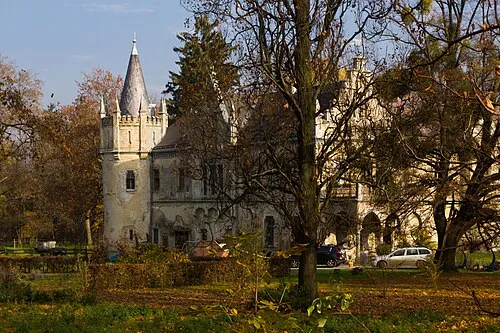 Schloss Walterskirchen Historic site, Wolfsthal6 km S
-
 Primate's Palace Historic site, Bratislava-Staré Mesto7.5 km SE
-
Morava River, Austria4.6 km SW
-
Rußbach River, Lower Austria5.1 km W
-
Stempfelbach River, Lower Austria5.2 km W
Sources & licences
Data last updated: · 2 independent sources