Letanovce
Located in Okres Spišská Nová Ves, Košice Region Coordinates: 48°58′35″ N 20°27′53″ E

- Population
- 2,353
- 2.4K
- Elevation
- 509 m
- above sea level
- Local time
- UTC+01:00
- Europe/Bratislava · UTC+01:00
- Airports
- TAT Poprad-Tatry Airport19 km
- KSC Košice International Airport67 km
About Letanovce
Letanovce is a village. Location: Okres Spišská Nová Ves, Košice Region. Population: 2,353. Elevation: 509 m.
Letanovce (Hungarian: Létánfalva) is a village and municipality in the Spišská Nová Ves District in the Košice Region of central-eastern Slovakia. In historical records the village was first mentioned in 1250. The village lies at an altitude of 511 metres and covers an area of 21.38 km2. As of 2011 it has a population of 2,133 inhabitants; about 70% are Slovaks, 20% are Roma.
Source: Wikipedia · CC BY-SA 4.0
Photos of Letanovce
-
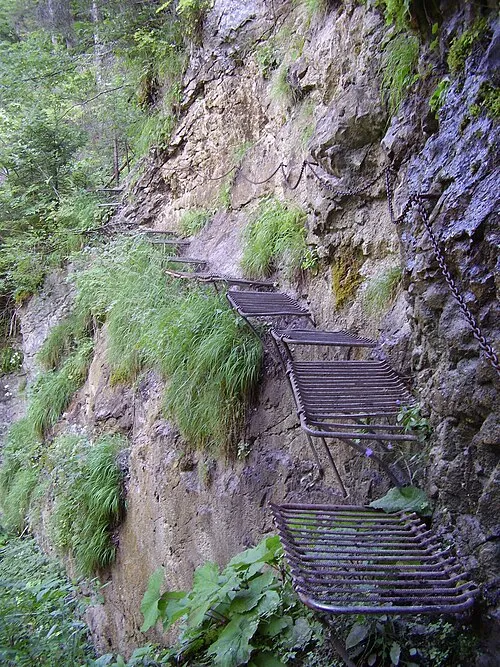
Prielom Hornádu Honza Groh · CC BY-SA 3.0

Population of Letanovce over time
| 2017 | 2,280 | |
|---|---|---|
| 2021 | 2,265 | |
| 2024 | 2,326 | |
| 2025 | 2,353 |
Censuses and official estimates; source: Wikidata.
Climate of Letanovce
Best months for sightseeingBest months for sightseeing: June–August.
This month · November
A cold month
Day 6° · Night -1° · Rain 47 mm
- Hottest month
- July (day 22°)
- Coldest month
- January (night -6°)
- Wettest month
- June (104 mm)
- Driest month
- February (29 mm)
Bars: average monthly low and high temperature. Below: precipitation. Monthly averages for 1970–2000 at about 18 km resolution, adjusted for elevation. Highlighted months are mild and relatively dry. Source: WorldClim 2.1 (CC BY 4.0).
Show values as a table
| Month | Jan | Feb | Mar | Apr | May | Jun | Jul | Aug | Sep | Oct | Nov | Dec |
|---|---|---|---|---|---|---|---|---|---|---|---|---|
| Average high (°C) | 1° | 3° | 7° | 12° | 18° | 21° | 22° | 22° | 18° | 13° | 6° | 2° |
| Average low (°C) | -6° | -5° | -2° | 3° | 8° | 10° | 12° | 11° | 8° | 4° | -1° | -4° |
| Precipitation (mm) | 33 | 29 | 33 | 57 | 84 | 104 | 91 | 80 | 62 | 49 | 47 | 37 |
How to get to Letanovce
The nearest airport is Poprad-Tatry Airport (TAT), 19 km to the northwest as the crow flies. The nearest large city is Košice, 65 km to the southeast.
Airports
- Poprad-Tatry Airport (TAT) Poprad 19 kmnorthwest
- Košice International Airport (KSC) Košice 67 kmsoutheast
- Sliač Airport (SLD) Sliač 105 kmwest
Nearby large cities
- Košice Population: 225K 65 kmsoutheast
- Miskolc Population: 154.5K 100 kmsouth
- Nyíregyháza Population: 117.7K 146 kmsoutheast
- Debrecen Population: 202.4K 182 kmsoutheast
- Satu Mare Population: 112.5K 221 kmsoutheast
Straight-line distances; road distances are longer. Airport data: OurAirports.
Day trips from Letanovce
Within 100 km: 22 historic and cultural sites, 251 natural sites, 15 lakes, rivers and coasts.
0–25 km7 places
- Ľubica River 18 kmN
- Spišská Kapitula Attraction 20 kmE
- Spiš Castle Historic site 22 kmE
- Slovenský Raj Mountain 8 kmSW
25–60 km126 places
- Skalnaté pleso Lake 29 kmNW
- Popradské Pleso Lake 34 kmNW
- Ostrá Mountain 38 kmNW
- Vysoká Mountain 35 kmNW
60–100 km155 places
- Rakytov Mountain 94 kmW
- Poľana Mountain 81 kmSW
- Baníkov Mountain 60 kmNW
- Cigelka River 67 kmNE
Straight-line distances.
Nearby attractions & nature
Everything nearby-
Prielom Hornádu Natural site, Czechia3.1 km S
-
Slovenský Raj Mountain, Košice Region7.7 km SW
-
Spiš Castle Historic site, Okres Spišská Nová Ves22 km E
-
Wooden Articular Church in Kežmarok Attraction, Kežmarok18 km N
-
Spišská Kapitula Attraction, Levoča District20 km E
-
Ľubica River, Prešov Region18 km N
Other cities and towns in Okres Spišská Nová Ves
-
 Harichovce Village, Okres Spišská Nová Ves8.8 km E
-
 Iliašovce Village, Okres Spišská Nová Ves4.8 km E
-
 Markušovce Village, Okres Spišská Nová Ves14 km SE
-
 Betlanovce Village, Okres Spišská Nová Ves5.5 km W
-
 Chrasť nad Hornádom Village, Okres Spišská Nová Ves18 km E
-
 Rudňany Village, Okres Spišská Nová Ves19 km SE
Sources & licences
Data last updated: · 2 independent sources