- Elevation
- 498 m
- above sea level
- Local time
- UTC+01:00
- Europe/Madrid · UTC+01:00
- Airports
- LEI Almería Airport29 km
- GRX F.G.L. Airport Granada-Jaén Airport110 km
About Gebera
Gebera is a village. Location: Alboloduy, Almeria. Elevation: 498 m. The best months to visit are April–May, October. The nearest airport is Almería Airport (29 km). Nearby sights include El Peñón del Moro and Iglesia Parroquial de Santa María.
Climate of Gebera
Best months for sightseeingBest months for sightseeing: April–May, October.
This month · November
Outside the best season
Day 18° · Night 7° · Rain 43 mm
Better nearby cities in November
- Almería · 26 km south20°
- Cartagena · 150 km northeast21°
- Murcia · 161 km northeast20°
- Hottest month
- July (day 35°)
- Coldest month
- January (night 4°)
- Wettest month
- December (44 mm)
- Driest month
- July (4 mm)
Bars: average monthly low and high temperature. Below: precipitation. Monthly averages for 1970–2000 at about 18 km resolution, adjusted for elevation. Highlighted months are mild and relatively dry. Source: WorldClim 2.1 (CC BY 4.0).
Show values as a table
| Month | Jan | Feb | Mar | Apr | May | Jun | Jul | Aug | Sep | Oct | Nov | Dec |
|---|---|---|---|---|---|---|---|---|---|---|---|---|
| Average high (°C) | 14° | 16° | 18° | 20° | 25° | 30° | 35° | 34° | 30° | 24° | 18° | 15° |
| Average low (°C) | 4° | 4° | 6° | 8° | 11° | 15° | 18° | 19° | 15° | 11° | 7° | 5° |
| Precipitation (mm) | 43 | 35 | 33 | 37 | 30 | 17 | 4 | 4 | 18 | 40 | 43 | 44 |
How to get to Gebera
The nearest airport is Almería Airport (LEI), 29 km to the southeast as the crow flies. For international flights: Region of Murcia International Airport (RMU) (150 km). The nearest large city is Almería, 26 km to the south.
Airports
- Almería Airport (LEI) Almería 29 kmsoutheast
- F.G.L. Airport Granada-Jaén Airport (GRX) Granada 110 kmwest
- Region of Murcia International Airport (RMU) Corvera 150 kmnortheast
Nearby large cities
- Almería Population: 196.9K 26 kmsouth
- Granada Population: 233.5K 95 kmwest
- Jaén Population: 113.5K 135 kmnorthwest
- Cartagena Population: 213.9K 151 kmnortheast
- Murcia Population: 472K 162 kmnortheast
Straight-line distances; road distances are longer. Airport data: OurAirports.
Day trips from Gebera
Within 100 km: 197 historic and cultural sites, 130 natural sites, 192 lakes, rivers and coasts.
0–25 km34 places
- Tetica Mountain 24 kmNE
- Peñón de Polarda Mountain 23 kmW
- Piorno Mountain 19 kmSW
- Sierra Nevada Mountain 22 kmW
25–60 km207 places
- Playa de Carboneras Beach 59 kmE
- Playa de San Nicolás Beach 55 kmSW
- Playa de Nueva Almería Beach 29 kmS
- Playa de los muertos Beach 59 kmE
60–100 km278 places
- Playa de las Delicias Beach 95 kmNE
- Playa Granada Beach 99 kmSW
- Playa Castell Del Ferro - Sotillo Beach 82 kmSW
- Playa de Poniente Beach 97 kmSW
Straight-line distances.
Nearby attractions & nature
Everything nearby-
El Peñón del Moro Historic site, Alboloduy7.7 km SW
-
Iglesia Parroquial de Santa María Attraction, Gérgal6.3 km N
-
Castillo de Gergal Historic site, Gérgal6.5 km N
-
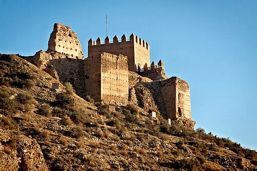 Castillo de Tabernas Historic site, Tabernas13 km E
-
Fuerte El Condor Historic site, Tabernas8.9 km E
-
Nueva Frontera Historic site, Tabernas9.5 km SE
Sources & licences
Data last updated: