Playa de Torrenueva
Located in Línea de la Concepción, La, Cadiz Coordinates: 36°12′23″ N 5°19′33″ W
- Elevation
- 1 m
- above sea level
- Local time
- UTC+01:00
- Europe/Madrid · UTC+01:00
- Airports
- GIB Gibraltar Airport6 km
- TTU Sania Ramel Airport68 km
About Playa de Torrenueva
Playa de Torrenueva is a beach. Location: Línea de la Concepción, La, Cadiz.
Playa de Torrenueva is a beach in the municipality of La Línea de la Concepción, in the Province of Cádiz, Andalusia, Spain, located to the northeast of Gibraltar. It has a length of about 1,250 metres (4,100 ft) and average width of about 120 metres (390 ft). It is a busy little beach north of the city and bordered on the south by the Playa de La Atunara and north by the Playa de La Hacienda.
Source: Wikipedia · CC BY-SA 4.0
Photos of Playa de Torrenueva
-
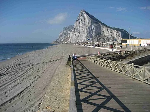
Playa de Santa Bárbara David Stanley · CC BY 2.0

Climate of Playa de Torrenueva
Best months for sightseeingBest months for sightseeing: May–June, September–October.
This month · November
A wet month
Day 20° · Night 13° · Rain 107 mm
Better nearby cities in November
- Málaga · 99 km northeast20°
- Dos Hermanas · 131 km northwest20°
- Seville · 143 km northwest20°
- Hottest month
- August (day 29°)
- Coldest month
- January (night 9°)
- Wettest month
- December (138 mm)
- Driest month
- July (1 mm)
Bars: average monthly low and high temperature. Below: precipitation. Monthly averages for 1970–2000 at about 18 km resolution, adjusted for elevation. Highlighted months are mild and relatively dry. Source: WorldClim 2.1 (CC BY 4.0).
Show values as a table
| Month | Jan | Feb | Mar | Apr | May | Jun | Jul | Aug | Sep | Oct | Nov | Dec |
|---|---|---|---|---|---|---|---|---|---|---|---|---|
| Average high (°C) | 16° | 17° | 19° | 20° | 23° | 26° | 29° | 29° | 27° | 23° | 20° | 17° |
| Average low (°C) | 9° | 10° | 11° | 12° | 14° | 17° | 19° | 20° | 19° | 16° | 13° | 11° |
| Precipitation (mm) | 110 | 79 | 70 | 57 | 30 | 10 | 1 | 4 | 16 | 66 | 107 | 138 |
Other places to visit in this season: May June September October
How to get to Playa de Torrenueva
The nearest airport is Gibraltar Airport (GIB), 6 km to the south as the crow flies. The nearest large city is Algeciras, 14 km to the southwest.
Airports
- Gibraltar Airport (GIB) Gibraltar 6 kmsouth
- Sania Ramel Airport (TTU) Tétouan 68 kmsouth
- Tangier Ibn Battuta Airport (TNG) Tangier 75 kmsouthwest
Nearby large cities
- Algeciras Population: 121.4K 14 kmsouthwest
- Marbella Population: 156.3K 52 kmnortheast
- Tétouan Population: 415.8K 70 kmsouth
- Jerez de la Frontera Population: 212.9K 90 kmnorthwest
- Cadiz Population: 117K 93 kmnorthwest
Straight-line distances; road distances are longer. Airport data: OurAirports.
Day trips from Playa de Torrenueva
Within 100 km: 343 historic and cultural sites, 210 natural sites, 338 lakes, rivers and coasts.
0–25 km107 places
- Playa de Poniente Beach 6 kmS
- Playa de Levante Beach 2 kmS
- La Alcaidesa Beach 3 kmN
- Playa de La Hacienda Beach 6 kmSW
25–60 km303 places
- Jbel Moussa Mountain 35 kmS
- Playa de San Amaro Beach 35 kmS
- Playa de Benítez Beach 35 kmS
- Playa de Benzú Beach 32 kmS
60–100 km481 places
- Playa de Zahora Beach 65 kmW
- Jebel Zem Zem Mountain 63 kmSW
- Kasbah Mosque Attraction 64 kmSW
- Grand Mosque of Tangier Attraction 64 kmSW
Straight-line distances.
Nearest towns and villages
-
La Línea de la Concepción Town, Línea de la Concepción, La4.7 km SW
-
 San Roque Municipality, Cadiz5.2 km N
-
San Roque Town, San Roque5.3 km W
-
La Atunara Village, Línea de la Concepción, La4.3 km S
-
Alcaidesa Village, San Roque3.7 km N
-
 Puente Mayorga Village, San Roque5.8 km SW
Nearby attractions & nature
Everything nearby-
Playa La Atunara Beach, Cadiz2.5 km S
-
Playa de Levante Beach, Cadiz1.9 km S
-
Playa de Santa Bárbara Beach, Cadiz4.4 km S
-
La Alcaidesa Beach, Cadiz3.2 km N
-
Playa Con Eduardo Beach, Cadiz4.4 km NE
-
Playa de Poniente Beach, Línea de la Concepción, La5.5 km S
-
Carbonera Watch Tower (historical) Landmark, San Roque3.1 km W
-
Playa de La Hacienda Beach, Cadiz5.7 km SW
Sources & licences
Data last updated: · 2 independent sources