- Local time
- UTC+01:00
- Europe/Madrid · UTC+01:00
- Elevation
- 705 m
- above sea level
- Airports
- AGP Málaga-Costa del Sol Airport60 km
- GIB Gibraltar Airport67 km
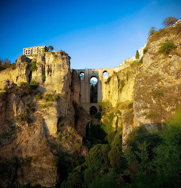
About Puente Nuevo
Puente Nuevo is a landmark. Location: Ronda, Malaga.
The Puente Nuevo (Spanish pronunciation: [ˈpwente ˈnweβo], "New Bridge"), completed in 1793, is the newest and largest of three bridges that span the 120-metre-deep (390 ft) chasm, the El Tajo Gorge, that carries the Guadalevín River and divides the city of Ronda, in southern Spain. The architect was José Martin de Aldehuela and the chief builder was Juan Antonio Díaz Machuca. The construction of the newest bridge (the one standing as of 2024) was started in 1759 and took 34 years.
Source: Wikipedia · CC BY-SA 4.0
At a glance
- Architect
- Martín de Aldehuela
- Height
- 98 m
- Length
- 0.1 km
Source: Wikidata
Climate of Puente Nuevo
Best months for sightseeingBest months for sightseeing: May–June, September–October.
This month · November
A wet month
Day 16° · Night 7° · Rain 114 mm
Better nearby cities in November
- Málaga · 66 km east20°
- Dos Hermanas · 90 km northwest20°
- Seville · 101 km northwest20°
- Hottest month
- July (day 32°)
- Coldest month
- January (night 3°)
- Wettest month
- December (121 mm)
- Driest month
- July (2 mm)
Bars: average monthly low and high temperature. Below: precipitation. Monthly averages for 1970–2000 at about 18 km resolution, adjusted for elevation. Highlighted months are mild and relatively dry. Source: WorldClim 2.1 (CC BY 4.0).
Show values as a table
| Month | Jan | Feb | Mar | Apr | May | Jun | Jul | Aug | Sep | Oct | Nov | Dec |
|---|---|---|---|---|---|---|---|---|---|---|---|---|
| Average high (°C) | 12° | 14° | 16° | 18° | 22° | 27° | 32° | 32° | 27° | 21° | 16° | 13° |
| Average low (°C) | 3° | 4° | 5° | 8° | 10° | 14° | 17° | 17° | 15° | 11° | 7° | 5° |
| Precipitation (mm) | 117 | 105 | 95 | 65 | 46 | 17 | 2 | 4 | 23 | 74 | 114 | 121 |
Other places to visit in this season: May June September October
How to get to Puente Nuevo
The nearest airport is Málaga-Costa del Sol Airport (AGP), 60 km to the east as the crow flies. The nearest large city is Marbella, 35 km to the southeast.
Airports
- Málaga-Costa del Sol Airport (AGP) Málaga 60 kmeast
- Gibraltar Airport (GIB) Gibraltar 67 kmsouth
- Jerez Airport (XRY) Jerez de la Frontera 80 kmwest
Nearby large cities
- Marbella Population: 156.3K 35 kmsoutheast
- Málaga Population: 592.3K 67 kmeast
- Algeciras Population: 121.4K 72 kmsouth
- Jerez de la Frontera Population: 212.9K 87 kmwest
- Dos Hermanas Population: 122.9K 90 kmnorthwest
Straight-line distances; road distances are longer. Airport data: OurAirports.
Day trips from Puente Nuevo
Within 100 km: 495 historic and cultural sites, 244 natural sites, 457 lakes, rivers and coasts.
0–25 km79 places
- Torrecilla Mountain 17 kmSE
- Sierra de Tolox Mountain 18 kmE
- Sierra de la Sanguijuela Mountain 7 kmNW
- Cerro de la Rosa Mountain 17 kmS
25–60 km375 places
- La Alcaidesa Beach 58 kmS
- Playa Bonita Beach 57 kmE
- Playa de Río Guadiaro Beach 52 kmS
- Cala Sardina Beach 49 kmS
60–100 km742 places
- Playa de Zahora Beach 99 kmSW
- Playa de San Amaro Beach 94 kmS
- Playa de Levante Beach 97 kmW
- Playa de la Caleta Beach 68 kmE
Straight-line distances.
Nearby attractions & nature
Everything nearby-
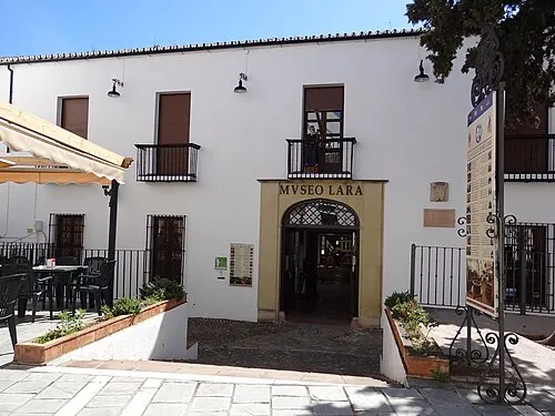 Museo Lara Museum, Ronda0.2 km SE
-
La Mina Historic site, Ronda0.2 km SE
-
Casa del Rey Moro Historic site, Ronda0.2 km SE
-
Ronda Bullring Attraction, Ronda0.2 km NW
-
Felipe V Arch Landmark, Ronda0.3 km SE
-
Nuestra Señora del Socorro Attraction, Ronda0.3 km N
-
Baños árabes Museum, Ronda0.3 km SE
-
Mondragon Palace Museum, Ronda0.3 km S
Nearest towns and villages
Sources & licences
Data last updated: · 2 independent sources