Palos de la Frontera
Located in Province of Huelva, Andalusia Coordinates: 37°11′36″ N 6°53′31″ W
- Population
- 9,809
- 9.8K
- Elevation
- 25 m
- above sea level
- Local time
- UTC+01:00
- Europe/Madrid · UTC+01:00
- Places inside
- 7
- listed under Palos de la Frontera
- Airports
- XRY Jerez Airport89 km
- SVQ Seville Airport92 km
About Palos de la Frontera
Palos de la Frontera is a municipality. Location: Province of Huelva, Andalusia. Population: 9,809. Elevation: 25 m. The best months to visit are March–June, October. The nearest airport is Jerez Airport (89 km). Nearby sights include Arroyo de Juana Ruíz and Arroyo de Juan Delgado.
Photos of Palos de la Frontera
-
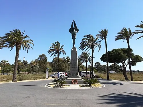
Monumento al Plus Ultra CarlosVdeHabsburgo · CC BY-SA 4.0

Climate of Palos de la Frontera
Best months for sightseeingBest months for sightseeing: March–June, October.
This month · November
Outside the best season
Day 20° · Night 10° · Rain 76 mm
Better nearby cities in November
- Seville · 84 km east20°
- Dos Hermanas · 87 km east20°
- Málaga · 226 km east20°
- Hottest month
- July (day 32°)
- Coldest month
- January (night 7°)
- Wettest month
- December (80 mm)
- Driest month
- July (2 mm)
Bars: average monthly low and high temperature. Below: precipitation. Monthly averages for 1970–2000 at about 18 km resolution, adjusted for elevation. Highlighted months are mild and relatively dry. Source: WorldClim 2.1 (CC BY 4.0).
Show values as a table
| Month | Jan | Feb | Mar | Apr | May | Jun | Jul | Aug | Sep | Oct | Nov | Dec |
|---|---|---|---|---|---|---|---|---|---|---|---|---|
| Average high (°C) | 16° | 17° | 20° | 21° | 24° | 28° | 32° | 32° | 29° | 25° | 20° | 17° |
| Average low (°C) | 7° | 8° | 9° | 11° | 13° | 17° | 19° | 19° | 17° | 14° | 10° | 8° |
| Precipitation (mm) | 71 | 48 | 37 | 46 | 27 | 12 | 2 | 4 | 15 | 57 | 76 | 80 |
Other places to visit in this season: March April May June October
How to get to Palos de la Frontera
The nearest airport is Jerez Airport (XRY), 89 km to the southeast as the crow flies. For international flights: Seville Airport (SVQ) (92 km). The nearest large city is Huelva, 9 km to the northwest.
Airports
- Jerez Airport (XRY) Jerez de la Frontera 89 kmsoutheast
- Seville Airport (SVQ) Seville 92 kmeast
- Faro - Gago Coutinho International Airport (FAO) Faro 98 kmwest
Nearby large cities
- Huelva Population: 144.3K 9 kmnorthwest
- Seville Population: 686.7K 84 kmeast
- Dos Hermanas Population: 122.9K 87 kmeast
- Jerez de la Frontera Population: 212.9K 88 kmsoutheast
- Cadiz Population: 117K 91 kmsoutheast
Straight-line distances; road distances are longer. Airport data: OurAirports.
Day trips from Palos de la Frontera
Within 100 km: 320 historic and cultural sites, 92 natural sites, 336 lakes, rivers and coasts.
0–25 km105 places
- Playa de Castilla Beach 6 kmS
- Playa de Punta Umbría Beach 9 kmW
- Playa de la Bota Beach 12 kmW
- Playa de Mazagón Beach 11 kmSE
25–60 km190 places
- Playa de Castilla Beach 31 kmSE
- Punta del Moral Beach 40 kmW
- Punta del Caiman Beach 39 kmW
- Playa de Matalascañas Beach 37 kmSE
60–100 km453 places
- Playa de la Victoria Beach 94 kmSE
- Playa de Levante Beach 93 kmSE
- Caleta Beach Beach 90 kmSE
- Playa de las Tres Piedras Beach 68 kmSE
Straight-line distances.
Places in Palos de la Frontera
7 placesBar: population relative to the most populous place in this list.
Cities & villages1
- La Rábida · Neighbourhood
Lakes, rivers & coasts4
- Arroyo Madre del Aviator · River
- Playa de Castilla · Beach
- Playa de Mazagón · Beach
- Playa de Rompeculos · Beach
Heritage & sights1
- Monumento al Plus Ultra · Landmark
Nearby attractions & nature
Everything nearby-
Arroyo de Juana Ruíz River, Andalusia1.1 km N
-
Arroyo de Juan Delgado River, Andalusia1.4 km W
-
Laguna Primera de Palos Lake, Andalusia2.5 km S
-
Laguna de la Mujer Lake, Andalusia3.5 km S
-
Saltes Island Island, Huelva5.7 km W
-
Monumento a Colón Landmark, Huelva4.8 km NW
-
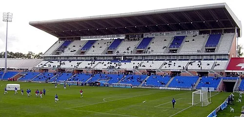 Estadio Nuevo Colombino Landmark, Huelva8.1 km NW
-
Río Tinto River, Spain4.5 km W
Other cities and towns in Province of Huelva
-
 Aljaraque Municipality, Province of Huelva15 km NW
-
 San Juan del Puerto Municipality, Province of Huelva16 km N
-
 Lucena del Puerto Municipality, Province of Huelva15 km NE
-
 Bonares Municipality, Province of Huelva21 km NE
-
 Lepe Municipality, Province of Huelva28 km W
-
 Trigueros Municipality, Province of Huelva26 km N
Sources & licences
Data last updated: