- Elevation
- 11 m
- above sea level
- Local time
- UTC+00:00
- Atlantic/Canary · UTC+00:00
- Airports
- FUE Fuerteventura Airport41 km
- ACE César Manrique-Lanzarote Airport100 km
About La Lajita
La Lajita is a village. Location: Pájara, Las Palmas. Elevation: 11 m. The best months to visit are October–June. The nearest airport is Fuerteventura Airport (41 km). Nearby sights include Jardín Botánico Fuerteventura and Oasis Park Fuerteventura.
Photos of La Lajita
-
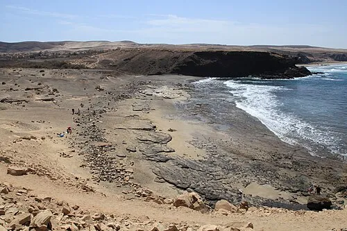
Playa de la Pared Frank Vincentz · CC BY-SA 3.0

Climate of La Lajita
Best months for sightseeingBest months for sightseeing: October–June.
This month · November
A good month to visit
Day 25° · Night 17° · Rain 19 mm
- Hottest month
- August (day 30°)
- Coldest month
- January (night 14°)
- Wettest month
- December (28 mm)
- Driest month
- July (0 mm)
Bars: average monthly low and high temperature. Below: precipitation. Monthly averages for 1970–2000 at about 18 km resolution, adjusted for elevation. Highlighted months are mild and relatively dry. Source: WorldClim 2.1 (CC BY 4.0).
Show values as a table
| Month | Jan | Feb | Mar | Apr | May | Jun | Jul | Aug | Sep | Oct | Nov | Dec |
|---|---|---|---|---|---|---|---|---|---|---|---|---|
| Average high (°C) | 21° | 22° | 24° | 24° | 25° | 27° | 29° | 30° | 29° | 27° | 25° | 23° |
| Average low (°C) | 14° | 14° | 15° | 16° | 17° | 18° | 20° | 21° | 21° | 19° | 17° | 15° |
| Precipitation (mm) | 17 | 19 | 13 | 6 | 1 | 1 | 0 | 0 | 5 | 8 | 19 | 28 |
Other places to visit in this season: January February March April May June October November December
How to get to La Lajita
The nearest airport is Fuerteventura Airport (FUE), 41 km to the northeast as the crow flies. The nearest large city is Las Palmas de Gran Canaria, 124 km to the west.
Airports
- Fuerteventura Airport (FUE) El Matorral 41 kmnortheast
- César Manrique-Lanzarote Airport (ACE) San Bartolomé 100 kmnortheast
- Gran Canaria Airport (LPA) Gran Canaria Island 125 kmwest
Nearby large cities
- Las Palmas de Gran Canaria Population: 383.5K 124 kmwest
- Telde Population: 123.3K 126 kmwest
- Santa Cruz de Tenerife Population: 211.4K 209 kmwest
- San Cristóbal de La Laguna Population: 150.7K 215 kmwest
Straight-line distances; road distances are longer. Airport data: OurAirports.
Day trips from La Lajita
Within 100 km: 50 historic and cultural sites, 62 natural sites, 70 lakes, rivers and coasts.
0–25 km53 places
- Fuerteventura Island 25 kmNE
- Playa La Solapa Beach 20 kmN
- La Caldera de Gairía Natural site 24 kmNE
- Iglesia de Nuestra Señora de la Regla Attraction 19 kmN
25–60 km67 places
- Bahía Toneles Natural site 28 kmNE
- Ensenada de Pozonegro Natural site 30 kmNE
- Orejas de Asno Mountain 25 kmSW
- Punta de Jandía Natural site 37 kmW
60–100 km62 places
- Playa Quemada Beach 90 kmNE
- Playa Mujeres Beach 82 kmNE
- Playa Blanca Beach 82 kmNE
- Las Clavellinas Beach 68 kmNE
Straight-line distances.
Nearby attractions & nature
Everything nearby-
Jardín Botánico Fuerteventura Attraction, Pájara0.7 km NW
-
Oasis Park Fuerteventura Attraction, Pájara0.7 km NW
-
Playa Puerto Rico Beach, Pájara2 km SW
-
Playa Caravanas Beach, Las Palmas1.2 km SW
-
Alto de los Garañones Mountain, Pájara4.4 km NW
-
Morro de la Cruzada Mountain, Tuineje4.1 km NE
Other cities and towns in Pájara
-
 Morro del Jable Village, Pájara25 km SW
-
Las Huertas Village, Pájara7.6 km N
-
Cardón Village, Pájara8.8 km N
-
Fayagua Village, Pájara13 km N
-
Ajuy Village, Pájara24 km N
-
Jandía Village, Pájara16 km SW
Sources & licences
Data last updated: