Villafranca del Bierzo
Located in Villafranca del Bierzo, Leon Coordinates: 42°36′22″ N 6°48′38″ W
- Population
- 3,733
- 3.7K
- Elevation
- 506 m
- above sea level
- Local time
- UTC+01:00
- Europe/Madrid · UTC+01:00
- Airports
- BGC Bragança Airport84 km
- LEN León Airport95 km
About Villafranca del Bierzo
Villafranca del Bierzo is a village. Location: Villafranca del Bierzo, Leon. Population: 3,733. Elevation: 506 m. The best months to visit are May–September. The nearest airport is Bragança Airport (84 km). Nearby sights include Estadio El Toralín and Río Burbia.
Climate of Villafranca del Bierzo
Best months for sightseeingBest months for sightseeing: May–September.
This month · November
A wet month
Day 13° · Night 5° · Rain 140 mm
- Hottest month
- July (day 28°)
- Coldest month
- January (night 2°)
- Wettest month
- December (143 mm)
- Driest month
- July (29 mm)
Bars: average monthly low and high temperature. Below: precipitation. Monthly averages for 1970–2000 at about 18 km resolution, adjusted for elevation. Highlighted months are mild and relatively dry. Source: WorldClim 2.1 (CC BY 4.0).
Show values as a table
| Month | Jan | Feb | Mar | Apr | May | Jun | Jul | Aug | Sep | Oct | Nov | Dec |
|---|---|---|---|---|---|---|---|---|---|---|---|---|
| Average high (°C) | 9° | 12° | 15° | 16° | 20° | 25° | 28° | 28° | 24° | 18° | 13° | 10° |
| Average low (°C) | 2° | 3° | 4° | 6° | 9° | 12° | 14° | 14° | 12° | 8° | 5° | 3° |
| Precipitation (mm) | 124 | 101 | 81 | 86 | 80 | 48 | 29 | 35 | 68 | 132 | 140 | 143 |
Other places to visit in this season: May June July August September
How to get to Villafranca del Bierzo
The nearest airport is Bragança Airport (BGC), 84 km to the south as the crow flies. For international flights: Asturias Airport (OVD) (124 km). The nearest large city is Ourense, 92 km to the west.
Airports
- Bragança Airport (BGC) Bragança 84 kmsouth
- León Airport (LEN) La Virgen del Camino 95 kmeast
- Asturias Airport (OVD) Ranón 124 kmnortheast
Nearby large cities
- Ourense Population: 105.2K 92 kmwest
- León Population: 124.8K 102 kmeast
- Oviedo Population: 220K 115 kmnortheast
- Gijón Population: 271.8K 139 kmnortheast
- A Coruña Population: 250.4K 155 kmnorthwest
Straight-line distances; road distances are longer. Airport data: OurAirports.
Day trips from Villafranca del Bierzo
Within 100 km: 80 historic and cultural sites, 119 natural sites, 231 lakes, rivers and coasts.
0–25 km33 places
- Montes Aquilanos Mountain 20 kmSE
- Serra dos Ancares Mountain 22 kmN
- Mustallar Mountain 24 kmN
- Formigueiros Mountain 24 kmW
25–60 km110 places
- Lago de Sanabria Lake 55 kmS
- Sierra Segundera Mountain 57 kmS
- Serra de Queixa Mountain 56 kmSW
- Sierra de Peña Negra Mountain 56 kmSE
60–100 km287 places
- Pantano de Villameca Lake 61 kmE
- Embalse de Belesar Lake 76 kmW
- Sierra de la Gamoneda Mountain 67 kmS
- Serra do Invernadoiro Mountain 66 kmSW
Straight-line distances.
Nearby attractions & nature
Everything nearby-
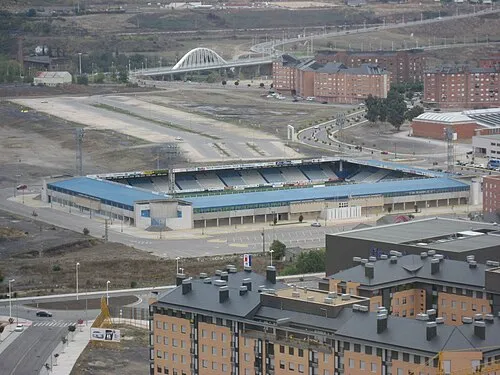 Estadio El Toralín Landmark, Ponferrada18 km E
-
Río Burbia River, Toral de los Vados8.5 km S
-
Fuentesnuevas Mediumwave Transmitter Landmark, Ponferrada14 km E
-
Río Ancares River, Cacabelos9.9 km NE
-
Río Cua River, Carucedo12 km S
-
Auditorio Municipal de Ponferrada Attraction, Ponferrada18 km SE
Sources & licences
Data last updated: